Felton, Queensland
| Felton Queensland | |||||||||||||
|---|---|---|---|---|---|---|---|---|---|---|---|---|---|
|
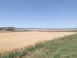
Farms along Southbrook Road, 2014 | |||||||||||||
 Felton | |||||||||||||
| Coordinates | 27°47′53″S 151°45′36″E / 27.79806°S 151.76000°ECoordinates: 27°47′53″S 151°45′36″E / 27.79806°S 151.76000°E | ||||||||||||
| Population | 244 (2011)[1] | ||||||||||||
| Postcode(s) | 4358 | ||||||||||||
| LGA(s) | Toowoomba Region | ||||||||||||
| State electorate(s) | Condamine | ||||||||||||
| Federal Division(s) | |||||||||||||
| |||||||||||||
Felton is a locality in the Toowoomba Region of the Darling Downs in southern Queensland, Australia. At the 2011 Australian Census Felton and surrounds recorded a population of 244.[1]
Hodgson Creek flows across the area and forms part of the southwest boundary. Mount Rolleston and Mount Perkins are both in Felton.
References
- ↑ 1.0 1.1 Australian Bureau of Statistics (31 October 2012). "Felton (State Suburb)". 2011 Census QuickStats. Retrieved 26 October 2014.
External links
![]() Media related to Felton, Queensland at Wikimedia Commons
Media related to Felton, Queensland at Wikimedia Commons
| ||||||||||||||||||