Felthorpe
| Felthorpe | |
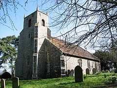 St Margaret's church |
|
 Felthorpe |
|
| Area | 8.70 km2 (3.36 sq mi) |
|---|---|
| Population | 710 |
| – density | 82/km2 (210/sq mi) |
| OS grid reference | TG169182 |
| Civil parish | Felthorpe |
| District | Broadland |
| Shire county | Norfolk |
| Region | East |
| Country | England |
| Sovereign state | United Kingdom |
| Post town | NORWICH |
| Postcode district | NR10 |
| Police | Norfolk |
| Fire | Norfolk |
| Ambulance | East of England |
| EU Parliament | East of England |
Coordinates: 52°43′07″N 1°12′37″E / 52.718515°N 1.210384°E
Felthorpe is a village and civil parish in the English county of Norfolk. It covers an area of 8.70 km2 (3.36 sq mi) and had a population of 710 in 287 households at the 2001 census.[1] For the purposes of local government, it falls within the district of Broadland.
The parish church of St Margaret, restored in 1878, dates from the 14th century and is a grade II* listed building. [2]
In 1966, Felthorpe was the location of a crash of a Trident aircraft that killed all four crew.
Notes
- ↑ Census population and household counts for unparished urban areas and all parishes. Office for National Statistics & Norfolk County Council (2001). Retrieved 20 June 2009.
- ↑ "Name: PARISH CHURCH OF ST MARGARET List entry Number: 1051539". English Heritage. Retrieved 13 March 2014.
External links
![]() Media related to Felthorpe at Wikimedia Commons
Media related to Felthorpe at Wikimedia Commons
| ||||||||||||||