Feldsee
| Feldsee | |
|---|---|
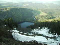 The Feldsee cirque seen from the Seebuck | |
| Location | Baden-Württemberg |
| Primary inflows | Seebach |
| Primary outflows | Seebach |
| Max. length | 0.35 km (0.22 mi) |
| Max. width | 0.36 km (0.22 mi) |
| Surface area | 0.0975 km2 (0.0376 sq mi) |
| Max. depth | 32 m (105 ft) |
| Shore length1 | 2.5 km (1.6 mi) |
| Surface elevation | 1,109 m (3,638 ft) |
| 1 Shore length is not a well-defined measure. | |
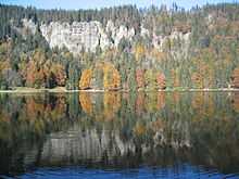
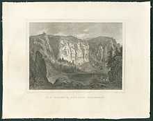
The Feldsee (also Feldbergsee) is a lake in southern Baden-Württemberg at the foot of the Feldberg east of Freiburg im Breisgau in Germany. It is part of the Southern Black Forest Nature Park.
Geology and earth history
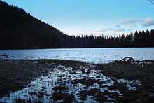
The Feldsee is a tarn, around 97,500 m² in area and up to 32 metres deep. It was formed by glaciers of the last Ice Age.[1] The largest tarn in the Black Forest, it is hemmed in on three sides by steep mountainsides up to 300 metres high. It is almost circular and has a diameter of between 350 and 370 metres. This area of highland at a height of 1,100 m, which is open to the northeast, enabled it to amass and retain the huge quantities of snow that were the cause of this armchair-shaped terrain with its steep back face, level floor and embankment of moraine at the front. The lake formed after the melting of the ice sheet behind the lines of heaped-up glacial debris.[2] The Seebach stream, which rises between the Feldberg and Seebuck in the Grüble, flows through the Feldsee, tumbling over the Feldsee Waterfall on the wall of the cirque, eventually becoming the Gutach at the far side of the Titisee. For several hundred thousand years this was the upper course of the Urdanube, which flowed into the present-day Danube near Immendingen and, for the last several ten thousand years has formed a headstream of the Wutach, which flows into the Rhine.
Below the Feldsee, between the heaps of moraine, used to be another, smaller lake that, through the formation of peat[2] has silted up to become the present-day, botanically valuable bog of Feldseemoor.
References
- ↑ Der Feldberg im Schwarzwald, Karl Müller L. Bielefeld, 1948
- ↑ 2.0 2.1 Dr. Wolfgang Fleck, Landesamt für Geologie, Rohstoffe und Bergbau
Literature
- Der Feldberg im Schwarzwald. Subalpine Insel im Mittelgebirge; mit Beiträgen von A. Bogenrieder, E. Liehl, E. Oberdorfer, G. Osche, W. Wimmenauer et al. (Photography: H. & K. Rasbach). – publ.: Landesanstalt für Umweltschutz Baden-Württemberg, Karlsruhe, 1982, (vergr.)
- Der Schwarzwald. Beiträge zur Landeskunde; eds.: E. Liehl & W. D. Sick – 2nd edn., Verlag Konkordia, Bühl 1982, (vergr.)
- August Vetter: Feldberg im Schwarzwald, Selbstverlag der Gemeinde Feldberg (Schwarzwald), 1982/1996
External links
| Wikimedia Commons has media related to Feldsee. |
| Wikisource has original text related to this article: |