Federation Trail
 | |
|---|---|
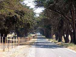
| Federation Trail near Werribee | |
| Federation Trail | |
| Length | Approx. 23 km from Brooklyn to Werribee |
| Difficulty | Easy |
| Hills | None |
| Hazards | Magpies during breeding season. Snakes in summer. |
| Path | Shared use, bitumen and gravel |
| Connecting Transport | |
| Train | Werribee line (Werribee and Hoppers Crossing stations) |
The Federation Trail is a shared use path for cyclists and pedestrians, which mainly follows the heritage-listed Main Outfall Sewer through the western suburbs of Melbourne, Victoria, Australia.[1][2][3] There are button-activated traffic light crossings at most major road-trail intersections.[4]
For safety reasons, cyclists are no longer allowed to ride on the Princes Freeway (or any other urban freeway).[5] The Federation Trail therefore is the preferred alternative route. West of Werribee, where the Federation Trail ends, Geelong cyclists may use the freeway shoulders, as it is then considered a rural freeway.[5]
The trail was officially opened on 22 October 2006.
In 2010 work started on extending the trail from Millers Road to Williamstown Rd. Completion of stage 1 of the VicRoads Truck Action Plan[6] should see the trail finally connected from Williamstown Road to the Hobsons Bay Coastal Trail on Hyde Street. In March 2011, work on the extension stopped completely, due to a change of government and troubles with funding and design of the bridge to Fogarty Avenue.[7][8] Thirteen hundred metres of concrete path had been built which lay idle until November 2014, when the bridge was completed.
In November 2014, VicRoads announced that the trail has been extended from Millers Road to Fogarty Avenue in Yarraville with the completion of the 124 metre bridge over the Brooklyn freight line. The next two stages include extending the trail to Williamstown Road and Hyde Street.[9]
Following the path
Much of the trail follows the historic reservation of the heritage listed Main Outfall Sewer which was built in the 1890s. At that time the sewer was the largest civil engineering project ever undertaken in Victoria. The associated pumping station can be found in the Scienceworks Museum complex.
Snakes may be seen in the Skeleton Creek and Werribee River areas during hot weather. Walkers are advised to stay on the path to enjoy the scenery.
Landmarks
Kororoit Creek, a tunnel under the Western Ring Road freeway, RAAF Williams (Laverton base), Lawrie Emmins Reserve, Skeleton Creek, Werribee Mercy Hospital, Victoria University (Werribee campus), Werribee Park, Werribee Open Range Zoo, Werribee River.
Connections
The trail meets the Werribee River Trail in the west, at Werribee and provides access to the Princes Freeway at this point. Near Hoppers Crossing it intersects with the upper section of the Skeleton Creek Trail. 3.7 km west of Millers Road, it intersects the Western Ring Road Trail. It terminates at Millers Road in the east in Brooklyn near Altona North.
The Hobsons Bay Coastal Trail can be accessed by relatively quiet back streets: At the east end of the trail, cross Fogarty Avenue to the shared path that accesses Mill Avenue and Benbow Street. Go north on Wembley Avenue to Freame Street. Take Drew Street to Austin Crescent East via the Stony Creek footbridge and then Anderson Street and Schild Street to the Bay Trail at Hyde Street. Be cautious on Anderson Street between Williamstown Road and Schild Street.
Another option of riding into the Melbourne City Centre is to leave the Federation Trail at Geelong Road and ride along the service lanes (and a pedestrian subway under the railway) to connect with one of the numerous paths or streets which go east-west through the Footscray area.
West end at 37°55′08″S 144°39′32″E / 37.918980°S 144.658795°E. East end at 37°49′26″S 144°52′16″E / 37.823945°S 144.871139°E.
References
- ↑ VicRoads - Bicycle Facilities Map
- ↑ Melbourne and Geelong's shared paths in Google Maps
- ↑ Melbourne and Geelong's shared paths in Google Earth
- ↑ http://www.bv.com.au/general/bikes-and-riding/30251/
- ↑ 5.0 5.1 http://www.vicroads.vic.gov.au/Home/SafetyAndRules/SaferRiders/BikeRiders/PlacesToRide.htm
- ↑ VicRoads Truck Action Plan
- ↑ BNV Federation Trail
- ↑ Grant Reynolds (11 April 2012). "Federation Trail's missing link takes alternative path". Hobsons Bay Weekly.
- ↑ "Federation Trail extension now open for cyclists and pedestrians" (Press release). VicRoads. 27 November 2014. Retrieved 1 February 2015.
External links
 Geographic data related to Federation Trail at OpenStreetMap
- VicRoads - Federation Trail shared path
- Bikely - Federation Trail map
| ||||||||||