Faxe Ladeplads
| Faxe Ladeplads | |
| Town | |
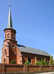
 Hylleholt Church in Faxe Ladeplads | |
| Country | Denmark |
|---|---|
| Region | Zealand (Sjælland) |
| Municipality | Faxe |
| Coordinates | 55°13′00″N 12°10′00″E / 55.21667°N 12.16667°ECoordinates: 55°13′00″N 12°10′00″E / 55.21667°N 12.16667°E |
| Population | 2,863 (2015) |
| Timezone | CET (UTC+1) |
| - summer (DST) | CEST (UTC+2) |
| Postal codes | 4654 |
 The location of Faxe Ladeplads in Denmark
| |
Faxe Ladeplads is a coastal town in Denmark with a population of 2,863 (1 January 2015),[1] located in Zealand and lying 5 kilometers south-east from Faxe. The town is mainly a harbour town with a working harbour and a marina. The town is a local beach-town and is surrounded by forest and sandy beaches with shallow water. The forest stretches all the way to the sea and from the edge you can see towards the island of Møn and the small protected wildlife park, Feddet.
History
The town was originally called Hylleholt. Today's name comes from a time in the 19th century when the countship of Vemmetofte decided to build a harbour to service the limestone industry up in the neighboring Faxe town. Ladeplads literally means stock area.
In the town you can find Hylleholt Church from 1878. The local railway (Østsjællands Jernbane) coming from Køge was inaugurated in 1879.
Education
Hylleholt School was founded in 1878. In the first years it was referred to as Strandskolen (The Beach School) because of the towns location by the beach.
In 1975 the building of a new school began on Dannebrogsvej 1, because of the old schools lack of modernization, expansion opportunities and due to the fact that the school was very expensive to warm up.
Attractions
The main attraction is the nature and fresh air from the sea. A couple of campsites exist in the area.
References
- ↑ BEF44: Population 1st January, by urban areas database from Statistics Denmark