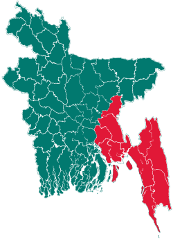
Fatikchhari Upazila
| Fatikchhari ফটিকছড়ি | |
|---|---|
| Upazila | |
 Fatikchhari Location in Bangladesh | |
| Coordinates: 22°41′N 91°48.3′E / 22.683°N 91.8050°ECoordinates: 22°41′N 91°48.3′E / 22.683°N 91.8050°E | |
| Country |
|
| Division | Chittagong Division |
| District | Chittagong District |
| Area | |
| • Total | 773.55 km2 (298.67 sq mi) |
| Population (1991) | |
| • Total | 388,013 |
| • Density | 502/km2 (1,300/sq mi) |
| Time zone | BST (UTC+6) |
| Website | Official Map of Fatikchhari |
Fatikchhari (Bengali: ফটিকছড়ি) is an Upazila of Chittagong District in the Division of Chittagong, Bangladesh.[1]
Geography
Fatikchhari is located at 22°41′00″N 91°48′15″E / 22.6833°N 91.8042°E. Fatickchari has a total area of 773.55 km².
It is one of the largest Upazilas of Bangladesh. It is a fertile valley between the Sitakund Hills and the Hills of the Chittagong Hill Tracts. These two hill ranges become one at the northernmost point of the upazila and they widen apart as they proceed southwards. There is no particular geographical place in the Upazila called Fatickchari, rather the entire upazila takes its name from one small all-season rivulet known as Fatickchari Khal that originates in the Sitakund Hills on the West and enters the Upazila at Bhujpur Union before joining the River Halda, the longest river in Fatikchhari Upazila that runs through the upazila along almost its entire length. Dhurung is its second longest river. There are some small rivers (khals) originating from the hills both on the eastern and western flanks, all being tributaries of the Halda flowing southwards to the sea. Among them are Gazaria, Fatickchari, Baramasia, Mandakini, Balukhali etc. In between the two hill ranges, Fatickchari consists of flat farmland annually affected by flash floods caused by heavy rainfall in the hilly catchment areas and the water being drained by several small rivers and the Halda.
It is surrounded by Tripura (India) to the north, Hathazari and Kawkhali upazila (Rangamati District) to the south, Ramgarh, Manikchhari, Lakshmichhari, and Raozan upazilas on the east, Mirsharai and Sitakunda upazilas on the west.
Demographics
According to the 1991 Bangladesh census, Fatikchhari had a population of 388,013, in 65,861 households. Males constituted 50.1% of the population, and females 49.9%. The population aged 18 or over was 182,250. Fatikchhari had an average literacy rate of 32% (7+ years), against the national average of 32.4% literate.[2]
The population is a mix of Bengali Muslims and Hindus, Buddhists (all bearing the title Barua); Tripura, Chakma, Mogh (these tribal groups are gradually retreating into the CHTs and are becoming rare in the upazila); and Manipuri and Uria (mainly tea garden workers).
Administration
Bibir Hat is the Administrative center of the Fatickchari Upazila. The old Fatickchari thana is divided into two Thanas (Police Stations)with Bhujpur created as a new thana in 2008 with its seat near Kazirhat. Fatikchhari has one Municipality and 20 Unions/Wards, 102 Mauzas/Mahallas, and 199 villages. The unions are:
Under Fatickchari Thana
- Abdullapur
- Baktapur
- Daulatpur
- Dharmapur
- Jafotnagar
- Kanchan Nagar
- Lelang
- Nanupur
- Paindong
- Roshangiri
- Samitirhat
- Rangamatia
- Dhurung
Under Bhujpur Thana
Educational institutions

There are six colleges in the Fatikchhari Upazila.[3] Shanthir hat Miskatunnabi Dakhil Madrasha
- Fatikchhari Degree College
- Isapur B.M.C. College
- Bhujpur National School & College
- Nanupur Layla Kabir College
- Narayan Hat Adarsha College
- Gultaz Memorial School & College
- Heako Bonani College
Schools
- Bhujpur Public High School
- Bhujpur National High School
- Bhujpur Model High School
- Nazirhat Adarsha high school
- Abdul Bari Chy High School
- Nazirhat Girl High School
- Shah Nagar High School
- Azimnagar Ahmodia High School
- Fatickchari Caronation High School
- Paindong High School
- Haidchokia High School
- Kanchanpur Bohumukhi High School
Madrasa
- Berazali Mazidiya Madrasa
- Kazirhat Amdadul Islam Madrasa
- Nanupur Obidul Islam Madrasa
- Babunogor Madrasa
- Bibir Hat Thalimuddin Madrasa
- Ramgor Madrasa
- West Bhujpur Balok Balika Madrasa
- Soabil Islam Madrasa
- Harual Chori Madrasa
Tea industry
17 of 163 of Bangladesh's 163 tea gardens are in Fatickchari Upazila.[4][5]
- Aasia Tea Garden
- Andharmanik Tea Garden
- Baramasia Tea Garden
- Dantmara Tea Garden
- Elahi-Noor Tea Garden
- Haldavalley Tea Garden
- Laiyacherra Tea Garden
- Karnafuli Tea Garden
- Maa Jaan Tea Garden
- Mohammad Nagar Tea Garden
- Naseha Tea Garden
- Neptune Tea Garden
- New Dantmara Tea Garden
- Oodaleah Tea Garden
- Panchabati Tea Garden
- Ramgarh Tea Garden
- Rangapani Tea Garden
See also
- Upazilas of Bangladesh
- Districts of Bangladesh
- Divisions of Bangladesh
- West Bhujpur, Talokdar Bari
References
- ↑ Tilak Barua Rubel (2012). "Fatikchhari Upazila". In Sirajul Islam and Ahmed A. Jamal. Banglapedia: National Encyclopedia of Bangladesh (Second ed.). Asiatic Society of Bangladesh.
- ↑ "Population Census Wing, BBS.". Archived from the original on 2005-03-27. Retrieved November 10, 2006.
- ↑ "Colleges in Chittagong". Bangladesh.jantareview.com. Retrieved 2012-08-28.
- ↑ "Bangladesh Tea Board". Teaboard.gov.bd. Retrieved 2012-08-28.
- ↑ "চা বাগান সমুহ - Fatickchari". Fatickchari.weebly.com. Retrieved 2012-08-28.
External links
| ||||||||||
| |||||||||||||||||||||||||||||||||||||||||||||||||||||
