Fassifern Valley
| Fassifern | |
| Valley | |
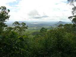 Fassifern Valley and Lake Moogerah viewed from the Main Range National Park | |
| Country | Australia |
|---|---|
| State | Queensland |
| Region | South East Queensland |

Fassifern Valley is a valley of the Scenic Rim in South East Queensland. Towns found in the valley include Harrisville, Kalbar, Roadvale, Warril View and Aratula. Fassifern Valley is known as a carrot producing area, as well as for growing potatoes, onions, pumpkins and melons.
The Cunningham Highway passes through the town of Aratula and along ridges in the upper valley towards Cunninghams Gap, Mount Mitchell and parts of Main Range National Park. The valley has become known as one of the driest catchments in the Queensland during recent droughts in Australia. The Moogerah Peaks are a series of mountain peaks in the south east of the catchment.
To the east lies the valleys of the Logan River. Further to the west is the dry catchment of Laidley Creek and Lockyer Creek in the Lockyer Valley while Amberley is located just to the north of the valley.
History
Captain Patrick Logan was the first European to explore the valley in 1827, during which he climbed Mount French.[1] The valley was first settled by pastoralists during the 1840s.[1][2] The first settlers in the area where John Cameron and his brother-in-law Robert Coulson.[3] The pair had arrived on the Darling Downs only to find all the best land already taken up. They eventually established themselves in the Fassifern Valley where number of other pastoral runs were established in the following decades, nearly all with familial connections to John Cameron. Cameron named the valley Fassefern which was a Scottish name.[3] Many of the sheep and cattle stations names from the 19th century became the names of villages and towns in the valley, such as Moogerah, Bromelton and Dugandan which was later to become known as Boonah.
In September 1887, the Dugandan railway line was opened connecting Dugandan to the main line in the north. Timber-cutting served at least five sawmills in the area.[1] The Mount Edwards railway line, a branch line of the Dugandan railway, serviced a number of towns in the valley between 1922 and 1960.
Moogerah Dam
Lake Moogerah was built on Reynolds Creek which runs into Warril Creek a tributary of the Bremer River which drains the slopes to the west of Fassifern Valley. Irrigation allowed local farmers to diversify crops after dairy farming declined in the 1960s.[2]
See also
- List of valleys of Australia
- Numinbah Valley
- Samford Valley
References
- ↑ 1.0 1.1 1.2 Seeing South-East Queensland (2 ed.). RACQ. 1980. p. 66. ISBN 0-909518-07-6.
- ↑ 2.0 2.1 Queensland Environmental Protection Agency (2000). Heritage Trails of the Great South East. State of Queensland. p. 27. ISBN 0-7345-1008-X.
- ↑ 3.0 3.1 Johnson, M. and Saunders, K. (2007). "Working The Land: An historical overview of Boonah and its northern district". State of Queensland. pp. 13–14. Retrieved 25 August 2010.
Coordinates: 27°48′39.4″S 152°39′54.2″E / 27.810944°S 152.665056°E