Farkadona
| Farkadona Φαρκαδόνα | |
|---|---|
 | |
 Farkadona | |
|
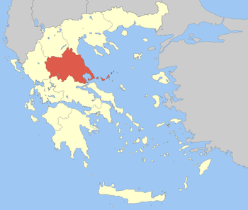
Location within the region  | |
| Coordinates: 39°35′N 22°04′E / 39.583°N 22.067°ECoordinates: 39°35′N 22°04′E / 39.583°N 22.067°E | |
| Country | Greece |
| Administrative region | Thessaly |
| Regional unit | Trikala |
| Area | |
| • Municipality | 368.67 km2 (142.34 sq mi) |
| Elevation | 248 m (814 ft) |
| Population (2011)[1] | |
| • Municipality | 13,396 |
| • Municipality density | 36/km2 (94/sq mi) |
| • Municipal unit | 5,877 |
| Time zone | EET (UTC+2) |
| • Summer (DST) | EEST (UTC+3) |
| Vehicle registration | ΤΚ |
| Website |
www |
Farkadona (Greek: Φαρκαδόνα, before 1955: Τσιότι - Tsioti[2]) is a municipality in the southeastern Trikala regional unit, part of Thessaly in Greece. In 2011 its population was 2,652 for the town and 13,396 for the municipality. It is located about halfway between the cities Larissa to the east, and Trikala to the west, at about 30 km from both. It is situated in the Thessalian Plain, near the river Pineios. Farkadona is on the Greek National Road 6 (Larissa - Trikala - Ioannina - Igoumenitsa).
Municipality
The municipality Farkadona was formed at the 2011 local government reform by the merger of the following 3 former municipalities, that became municipal units:[3]
- Farkadona
- Oichalia
- Pelinnaioi
Subdivisions
The municipal unit of Farkadona is divided into the following communities:
Population
| Year | Town | Municipal unit | Municipality |
|---|---|---|---|
| 1981 | 2,117 | - | - |
| 1991 | 2,330 | 7,456 | - |
| 2001 | 2,387 | 7,093 | - |
| 2011 | 2,052 | 5,877 | 13,396 |
History
Farkadona is named after the ancient Thessalian town Pharcadon (Ancient Greek: Φαρκαδών - Pharkadon). The ruins of ancient Pharcadon are located on a hill near the village of Klokotos,[4] 5 km southwest of the modern town. The modern town of Farkadona was known as Tsioti before 1955.[2]
External links
References
- ↑ "Detailed census results 2011" (in Greek).
- ↑ 2.0 2.1 Name changes of settlements in Greece
- ↑ Kallikratis law Greece Ministry of Interior (Greek)
- ↑ PHARKADON Thessaly, Greece, entry in The Princeton Encyclopedia of Classical Sites.
| ||||||||||||||
| ||||||||||||||||||||||||||||||||||