Faridkot district

Faridkot district (Punjabi: ਫਰੀਦਕੋਟ) is one of the twenty-two districts in the state of Punjab in North-West Republic of India. According to Punjab's Geo-Area, Faridkot is a Malwa district. It is one of the biggest cotton markets in South-East Asia. The name 'Faridkot' is derived from Baba Farid, a god-lover who wanted see the God. Faridkot was feudlist province under British rule, but now it is a district in Punjab in independent India. Few part of District Moga & Mukatsar were also taken from Faridkot.
Government body
Prior to independence large part of the district was under the princely rule of Sikh Maharaja of Faridkot and later it became part of the Patiala & East Punjab States Union (PEPSU ) in 1948. Faridkot was carved out as a separate district on 7 August 1972 out of the areas of Bathinda District (Faridkot Tehsil) and Ferozepur District (Moga and Muktsar Tehsils). However in November 1995, the Faridkot District was trifurcated when two of its sub divisions viz Muktsar and Moga were given the status of independent districts.
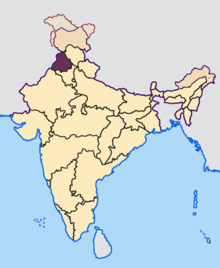
Faridkot district is surrounded by district Ferozepur in the North-West, Muktsar in the South-West, Bathinda in the South and Moga in the West. The District covers an area of 1469 km2. which is 2.92% of the total area of the State and accommodates a population of 552,466, which is 2.27% of the total population of the State. It has two Sub divisions/ Tehsils namely Faridkot and Jaito and two Sub Tehsils namely Kotkapura and Sadiq comprising a total of 171 villages. Faridkot District has two development blocks namely Faridkot and Kotkapura.
Overview
The Faridkot district contains a number of small towns. More than 7 villages are quite notable in Faridkot area. Faridkot is a hub for premier educational institutions. North India's only Medical University, also named after Baba Farid is in Faridkot besides Medical, Engineering and Dental Colleges. Faridkot majority population is dominated by Jatts.
Demographics
According to the 2011 census Faridkot district has a population of 618,008,[1] roughly equal to the nation of Solomon Islands[2] or the US state of Vermont.[3] This gives it a ranking of 519th in India (out of a total of 640).[1] The district has a population density of 424 inhabitants per square kilometre (1,100/sq mi) .[1] Its population growth rate over the decade 2001-2011 was 12.18%.[1] Faridkot has a sex ratio of 889 females for every 1000 males,[1] and a literacy rate of 70.6%.[1]
References
- ↑ 1.0 1.1 1.2 1.3 1.4 1.5 "District Census 2011". Census2011.co.in. 2011. Retrieved 2011-09-30.
- ↑ US Directorate of Intelligence. "Country Comparison:Population". Retrieved 2011-10-01.
Solomon Islands 571,890 July 2011 est.
- ↑ "2010 Resident Population Data". U. S. Census Bureau. Retrieved 2011-09-30.
Vermont 625,741
 |
Firozpur district | | ||
| |
Moga district | |||
| ||||
| | ||||
| Muktsar district | Bathinda district |
| ||||||||||
| |||||||||||||||||||||||||
Coordinates: 30°40′12″N 74°45′36″E / 30.67000°N 74.76000°E