Fan Hir
| Fan Hir | |
|---|---|
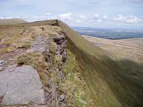 Fan Hir summit ridge | |
| Elevation | 760 m (2,490 ft) |
| Prominence | 43 m (141 ft) |
| Parent peak | Fan Brycheiniog |
| Listing | Hewitt, Nuttall |
| Translation | long beacon (Welsh) |
| Location | |
| Location | Powys, Wales |
| Range | Brecon Beacons |
| OS grid | SN825217 |
| Coordinates | 51°52′25″N 3°41′59″W / 51.8736°N 3.6996°WCoordinates: 51°52′25″N 3°41′59″W / 51.8736°N 3.6996°W |
Fan Hir is a peak at the eastern end of the Black Mountain in the Brecon Beacons National Park in south Wales. It is a subsidiary summit of Fan Brycheiniog. It falls within the county of Powys and is also a part of the traditional area of Fforest Fawr. Its Welsh name means 'long peak', a fitting description, particularly if seen from the east when its steep eastern face is seen to advantage. Its flat summit is just over 760m above sea level. Fan Hir is separated from its higher neighbour to the north-west, Fan Brycheiniog (802m) by a col known as Bwlch Giedd.[1]
The hill is drained to east and west by streams which make their way into the River Tawe.[2]
Geology
The peak is formed from sandstones of the Brownstones Formation and the overlying Plateau Beds Formation of the Old Red Sandstone laid down during the Devonian period. In accord with a regional trend, the beds dips southwards into the South Wales Coalfield basin. A notable feature of the hill is the prominent ridge of Fan Fechan (the 'little peak') which parallels the main ridge below it to the east. It is largely composed of broken Old Red Sandstone and has been interpreted as either a glacial moraine or as a pro-talus rampart. The peak is within the Fforest Fawr Geopark designated in 2005 in recognition of the area's geological heritage.[3]
Access
The entire hill is open country and thus available for walkers to roam at will. The path along the ridge is popular and forms a part of a popular circuit. The Beacons Way long distance footpath runs beneath Fan Hir on the east affording marvellous close-up views of this impressive hill.
References
- ↑ Nuttall, John & Anne (1999). The Mountains of England & Wales - Volume 1: Wales (2nd edition ed.). Milnthorpe, Cumbria: Cicerone. ISBN 1-85284-304-7.
- ↑ Ordnance Survey Explorer map OL12 'Brecon Beacons National Park: western area'
- ↑ British Geological Survey 1:50,000 map sheet 213 'Merthyr Tydfil' & accompanying memoir