False Bay (Livingston Island)

Location of Livingston Island in the South Shetland Islands.
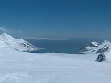
False Bay from Orpheus Gate, with Deception Island in the background.

Topographic map of Livingston Island, Greenwich, Robert, Snow and Smith Islands.
False Bay (62°43′S 60°22′W / 62.717°S 60.367°WCoordinates: 62°43′S 60°22′W / 62.717°S 60.367°W) is a bay 4 miles (6.4 km) long, which lies between Barnard Point and Miers Bluff on the south side of Livingston Island, in the South Shetland Islands, Antarctica. It was probably first entered and charted by Captain Nathaniel Palmer in November 1820, and was likely named because of the possibility in thick weather of confusion between this feature and nearby South Bay, where Johnsons Dock was frequented by the early sealers.[1]
Map
- L.L. Ivanov. Antarctica: Livingston Island and Greenwich, Robert, Snow and Smith Islands. Scale 1:120000 topographic map. Troyan: Manfred Wörner Foundation, 2009.
References
- ↑ "False Bay". Geographic Names Information System. United States Geological Survey. Retrieved 2012-03-13.
![]() This article incorporates public domain material from the United States Geological Survey document "False Bay" (content from the Geographic Names Information System).
This article incorporates public domain material from the United States Geological Survey document "False Bay" (content from the Geographic Names Information System).