Falls Township, Chase County, Kansas
| Falls Township | |
|---|---|
| Township | |
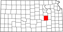
 Location in Chase County | |
| Coordinates: 38°20′30″N 096°31′46″W / 38.34167°N 96.52944°WCoordinates: 38°20′30″N 096°31′46″W / 38.34167°N 96.52944°W | |
| Country | United States |
| State | Kansas |
| County | Chase |
| Area | |
| • Total | 50.72 sq mi (131.37 km2) |
| • Land | 50.51 sq mi (130.83 km2) |
| • Water | 0.21 sq mi (0.55 km2) 0.42% |
| Elevation | 1,296 ft (395 m) |
| Population (2000) | |
| • Total | 1,163 |
| • Density | 23/sq mi (8.9/km2) |
| GNIS feature ID | 0477270 |
Falls Township is a township in Chase County, Kansas, USA. As of the 2000 census, its population was 1,163.
Geography
Falls Township covers an area of 50.72 square miles (131.4 km2) and contains one incorporated settlement, Cottonwood Falls (the county seat). According to the USGS, it contains two cemeteries: Miller and Prairie Grove.
The streams of Buck Creek, South Fork Cottonwood River, Spring Creek and Stout Run run through this township.
Transportation
Falls Township contains one airport or landing strip, Chase County Airport.
Further reading
See also: List of books about Chase County, Kansas
References
External links
- Burnley Memorial Library - Falls Township - Chase Co. Kansas
- City-Data.com
- Chase County Maps: Current, 1936
| |||||||||||||||||||||||||||||