Faial da Terra
| Faial da Terra | |
| Civil Parish | |
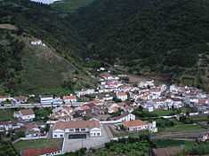 The central agglomeration of Faial da Terra, concentrated along the Ribeira da Terra | |
| Official name: Freguesia da Água Retorta | |
| Name origin: from Faya trees | |
| Country | |
|---|---|
| Autonomous Region | |
| Island | São Miguel |
| Municipality | Povação |
| Localities | Burguete, Faial da Terra, Outeiro, Rebentão, Sanguinho |
| Center | Sanguinho |
| - elevation | 82 m (269 ft) |
| - coordinates | 37°45′3″N 25°12′9″W / 37.75083°N 25.20250°WCoordinates: 37°45′3″N 25°12′9″W / 37.75083°N 25.20250°W |
| Highest point | |
| - location | Cerrado de Verão |
| - elevation | 674 m (2,211 ft) |
| - coordinates | 37°45′21″N 25°10′46″W / 37.75583°N 25.17944°W |
| Lowest point | Sea Level |
| - location | Atlantic Ocean |
| Area | 11.38 km2 (4 sq mi) |
| - urban | .23 km2 (0 sq mi) |
| Population | 359 (2011) |
| Density | 32 / km2 (83 / sq mi) |
| LAU | Junta Freguesia |
| - location | Rua da Avenida |
| - elevation | 19 m (62 ft) |
| - coordinates | 37°44′42″N 25°11′54″W / 37.74500°N 25.19833°W |
| President Junta | Paulo Nazaré (PS) |
| Timezone | Azores (UTC-1) |
| - summer (DST) | Azores (UTC0) |
| Postal Zone | 9650-114 |
| Area Code & Prefix | (+351) 296 586-XXX |
| Patron Saint | Nossa Senhora da Luz |
| Wikimedia Commons: Faial da Terra (Ponta Delgada) | |
| Statistics from INE (2001); geographic detail from Instituto Geográfico Português (2010) | |
Faial da Terra is a civil parish in the municipality of Povoação on the island of São Miguel in the Azores. The population in 2011 was 359,[1] in an area of 11.38 km².[2] It is located in the southeastern part of the island, on the south coast.
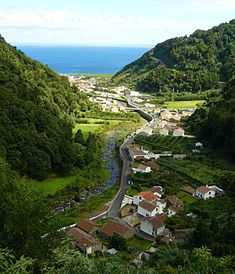
Faial da Terra as viewed from northern micro-settlement of Sanguinho and trail