Ewaso Ng'iro
| Ewaso Ng'iro Uaso Nyiro or Lagh Dera | |
|---|---|
| Origin | Mount Kenya |
| Basin countries | Kenya |
| Mouth elevation | 600 m |
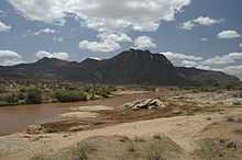
Ewaso Ng'iro is a river in Kenya which rises on the west side of Mount Kenya and flows north then east and finally south-east, passing through Somalia where it joins the Jubba River.[1] The upper basin of the Ewaso Ng'iro River is 15,200-square-kilometre (5,900 sq mi).[2] The river has a continuous water supply due to the glaciers on Mount Kenya. It is used for canoeing and has up to grade V rapids.[3]
The river's name is derived from the local community's language. It means the river of brown or muddy water. It is also called by some the "Ewaso Nyiro."
In the arid North of Kenya, water means life. The waters of this great river draw wildlife in great numbers to its banks, creating an oasis of green. Samburu, Shaba and Buffalo Springs National Reserves in Northern Kenya teem with wildlife in an otherwise arid land, because of the water of the river. Below Sericho, the river expands into the Lorian Swamp, a large area of wetlands.[4]
Ewaso Narok river is one of its tributaries. Thomson's Falls near Nyahururu town are located along Ewaso Narok.
See also
References
- ↑ Rough Guide Map Kenya (Map) (9 ed.). 1:900,000. Rough Guide Map. Cartography by World Mapping Project. Rough Guide. 2006. ISBN 1-84353-359-6.
- ↑ Makali, Samuel; Boniface Kiteme, (September 2005). "The Upper Ewaso Ng’iro Basin, Kenya". Network for Water and Sanitation. Archived from the original on 2007-05-24. Retrieved 2007-06-21.
- ↑ "The Ewaso-Ng'iro River". Kilimanjaro Adventure Travel. pre November 1996. Archived from the original on 2006-03-03. Retrieved 2007-06-21. Check date values in:
|date=(help) - ↑ R. H. Hughes, J. S. Hughes (1992). A directory of African wetlands. IUCN. ISBN 2-88032-949-3.
Coordinates: 2°04′S 36°07′E / 2.067°S 36.117°E
| ||||||||||