Everton, Victoria
| Everton Victoria | |
|---|---|
|
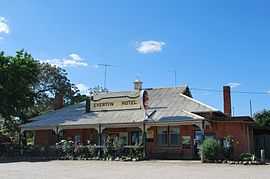
Everton Hotel | |
 Everton | |
| Coordinates | 36°25′0″S 146°32′0″E / 36.41667°S 146.53333°ECoordinates: 36°25′0″S 146°32′0″E / 36.41667°S 146.53333°E |
| Population | 341 (2011 census)[1] |
| Postcode(s) | 3678 |
| Location |
|
| LGA(s) | Rural City of Wangaratta |
| State electorate(s) | Ovens Valley |
| Federal Division(s) | Indi |
Everton is a small town located 20 kilometres (12 mi) from Wangaratta in northeast Victoria, along the Great Alpine Road. At the 2011 census, Everton and the surrounding area had a population of 341.[1]
Attractions of the town and area include the Murray to the Mountains Rail Trail (a sealed off-road bicycle path offering 95 kilometres (59 mi) of cycling along former railway tracks), wineries, and the Victorian High Country.
Everton Post Office opened in 1876 and closed in 1965. An earlier Everton office opened on 8 May 1873, was renamed Everton Station in 1876, Everton Rail around 1909, Everton Upper in 1922 and also closed in 1965.[2]
References
- ↑ 1.0 1.1 Australian Bureau of Statistics (31 October 2012). "Everton (State Suburb)". 2011 Census QuickStats. Retrieved 3 December 2014.
- ↑ Premier Postal History, Post Office List, retrieved 2008-04-11
External links
| Wikimedia Commons has media related to Everton, Victoria. |
| ||||||