Etowah County, Alabama
| Etowah County, Alabama | |
|---|---|
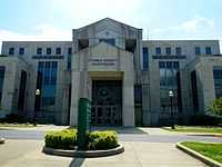 Etowah County courthouse in Gadsden | |
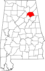 Location in the state of Alabama | |
 Alabama's location in the U.S. | |
| Founded | December 7, 1866 |
| Seat | Gadsden |
| Largest city | Gadsden |
| Area | |
| • Total | 549 sq mi (1,422 km2) |
| • Land | 535 sq mi (1,386 km2) |
| • Water | 14 sq mi (36 km2), 2.5% |
| Population | |
| • (2010) | 104,430 |
| • Density | 195/sq mi (75/km²) |
| Congressional district | 4th |
| Time zone | Central: UTC-6/-5 |
| Website |
www |
Etowah County is a county of the U.S. state of Alabama. As of the 2010 census the population was 104,430.[1] Its county seat is Gadsden.[2] Its name is from a Cherokee word meaning "edible tree". In total area, it is the smallest county in Alabama,but one of the most densely populated.
Etowah County comprises the Gadsden, AL Metropolitan Statistical Area.
History
Etowah was originally the southern part of DeKalb County, Alabama. However Baine County was established on December 7, 1866, named for General David W. Baine of the Confederate Army, with its county seat at Gadsden. On December 1, 1868 the county was abolished and Etowah County was created from the same territory.[3]
An F4 tornado struck here on Palm Sunday March 27, 1994. It destroyed Piedmont's Goshen United Methodist Church twelve minutes after the National Weather Service of Birmingham issued a tornado warning for northern Calhoun, southeastern Etowah, and southern Cherokee.
Geography
According to the U.S. Census Bureau, the county has a total area of 549 square miles (1,420 km2), of which 535 square miles (1,390 km2) is land and 14 square miles (36 km2) (2.5%) is water.[4] It is the smallest county by area in Alabama.
Adjacent counties
- DeKalb County, Alabama - north
- Cherokee County, Alabama - east
- Calhoun County, Alabama - southeast
- St. Clair County, Alabama - southwest
- Blount County, Alabama - west
- Marshall County, Alabama - northwest
Transportation
Major highways
.svg.png) Interstate 59
Interstate 59.svg.png) Interstate 759
Interstate 759 U.S. Route 11
 U.S. Route 278
 U.S. Route 411
 U.S. Route 431
 State Route 77
 State Route 132
 State Route 291
 State Route 759
Rail
- Alabama and Tennessee River Railway
- Norfolk Southern Railway
- Tennessee, Alabama and Georgia Railway (Defunct)
Demographics
| Historical population | |||
|---|---|---|---|
| Census | Pop. | %± | |
| 1870 | 10,109 | — | |
| 1880 | 15,398 | 52.3% | |
| 1890 | 21,926 | 42.4% | |
| 1900 | 27,361 | 24.8% | |
| 1910 | 39,109 | 42.9% | |
| 1920 | 47,275 | 20.9% | |
| 1930 | 63,399 | 34.1% | |
| 1940 | 72,580 | 14.5% | |
| 1950 | 93,892 | 29.4% | |
| 1960 | 96,980 | 3.3% | |
| 1970 | 94,144 | −2.9% | |
| 1980 | 103,057 | 9.5% | |
| 1990 | 99,840 | −3.1% | |
| 2000 | 103,459 | 3.6% | |
| 2010 | 104,430 | 0.9% | |
| Est. 2013 | 103,931 | −0.5% | |
| U.S. Decennial Census[5] 1790-1960[6] 1900-1990[7] 1990-2000[8] 2010-2013[1] | |||
As of the census[9] of 2000, there were 103,459 people, 41,615 households, and 29,463 families residing in the county. The population density was 193 people per square mile (75/km2). There were 45,959 housing units at an average density of 86 per square mile (33/km2). The racial makeup of the county was 82.87% White, 14.68% Black or African American, 0.33% Native American, 0.42% Asian, 0.03% Pacific Islander, 0.73% from other races, and 0.93% from two or more races. 1.70% of the population were Hispanic or Latino of any race.
There were 41,615 households out of which 29.90% had children under the age of 18 living with them, 54.20% were married couples living together, 13.10% had a female householder with no husband present, and 29.20% were non-families. 26.30% of all households were made up of individuals and 12.40% had someone living alone who was 65 years of age or older. The average household size was 2.44 and the average family size was 2.93.
In the county the population was spread out with 23.80% under the age of 18, 8.70% from 18 to 24, 27.40% from 25 to 44, 24.10% from 45 to 64, and 16.00% who were 65 years of age or older. The median age was 38 years. For every 100 females there were 91.80 males. For every 100 females age 18 and over, there were 87.90 males.
The median income for a household in the county was $31,170, and the median income for a family was $38,697. Males had a median income of $31,610 versus $21,346 for females. The per capita income for the county was $16,783. About 12.30% of families and 15.70% of the population were below the poverty line, including 21.60% of those under age 18 and 13.70% of those age 65 or over.
Communities
Cities
- Attalla
- Boaz (partly in Marshall County)
- Gadsden
- Glencoe (partly in Calhoun County)
- Hokes Bluff
- Rainbow City
- Southside (partly in Calhoun County)
Towns
- Altoona (partly in Blount County)
- Reece City
- Ridgeville
- Sardis City (partly in Marshall County)
- Walnut Grove
Census-designated places (CDPs)
Unincorporated communities
- Anderson
- Liberty Hill
- Pilgrims Rest
- Mountainboro, Boaz
See also
- National Register of Historic Places listings in Etowah County, Alabama
- Properties on the Alabama Register of Landmarks and Heritage in Etowah County, Alabama
References
- ↑ 1.0 1.1 "State & County QuickFacts". United States Census Bureau. Retrieved May 16, 2014.
- ↑ "Find a County". National Association of Counties. Retrieved 2011-06-07.
- ↑ "Alabama Counties: Etowah County". Alabama Department of Archives and History. Montgomery, AL: Alabama Department of Archives and History. 2011-10-25. Retrieved 2012-04-30.
- ↑ "US Gazetteer files: 2010, 2000, and 1990". United States Census Bureau. 2011-02-12. Retrieved 2011-04-23.
- ↑ "U.S. Decennial Census". United States Census Bureau. Retrieved May 16, 2014.
- ↑ "Historical Census Browser". University of Virginia Library. Retrieved May 16, 2014.
- ↑ "Population of Counties by Decennial Census: 1900 to 1990". United States Census Bureau. Retrieved May 16, 2014.
- ↑ "Census 2000 PHC-T-4. Ranking Tables for Counties: 1990 and 2000" (PDF). United States Census Bureau. Retrieved May 16, 2014.
- ↑ "American FactFinder". United States Census Bureau. Retrieved 2011-05-14.
External links
| Wikimedia Commons has media related to Etowah County, Alabama. |
 |
Marshall County | DeKalb County | | |
| Blount County | |
Cherokee County | ||
| ||||
| | ||||
| St. Clair County | Calhoun County |
| |||||||||||||||||||||||||||||
| ||||||||||||||||||||||||||||||||||