Estrée-Blanche
| Estrée-Blanche | |
|---|---|
 | |
 Estrée-Blanche | |
|
Location within Nord-Pas-de-Calais region  Estrée-Blanche | |
| Coordinates: 50°35′38″N 2°19′19″E / 50.5939°N 2.3219°ECoordinates: 50°35′38″N 2°19′19″E / 50.5939°N 2.3219°E | |
| Country | France |
| Region | Nord-Pas-de-Calais |
| Department | Pas-de-Calais |
| Arrondissement | Béthune |
| Canton | Norrent-Fontes |
| Intercommunality | Artois Flandres |
| Government | |
| • Mayor (2008–2014) | Bernard Delétré |
| Area1 | 5.32 km2 (2.05 sq mi) |
| Population (1999)2 | 928 |
| • Density | 170/km2 (450/sq mi) |
| INSEE/Postal code | 62313 / 62145 |
| Elevation |
37–99 m (121–325 ft) (avg. 43 m or 141 ft) |
|
1 French Land Register data, which excludes lakes, ponds, glaciers > 1 km² (0.386 sq mi or 247 acres) and river estuaries. 2 Population without double counting: residents of multiple communes (e.g., students and military personnel) only counted once. | |
Estrée-Blanche is a commune in the Pas-de-Calais department in the Nord-Pas-de-Calais region of France.
History
Indian Cavalry were stationed at Estrée-Blanche during the First World War
Geography

A farming village some 12 miles (19.3 km) to the northwest of Béthune and 30 miles (48.3 km) west of Lille, at the junction of the D341, D186 and the D159 roads. The small rivers Surgeon and Laquette converge at the commune.
Estrée-Blanche is found at the extreme edge of the coal-mining area of Nord-Pas-de-Calais. Part of its surface area was owned by the mining company, which ceased in the 1960s. All that remains of that era are some typical miners' houses.
Population
| Year | 1962 | 1968 | 1975 | 1982 | 1990 | 1999 |
|---|---|---|---|---|---|---|
| Population | 1022 | 1093 | 1068 | 1005 | 988 | 928 |
| From the year 1962 on: No double counting—residents of multiple communes (e.g. students and military personnel) are counted only once. | ||||||
Places of interest
- The church of St.Vaast, dating from the sixteenth century.
- The fifteenth-century chateau de Crémenil, built by the Le May family in 1443
-

The château from the west
-

The rear courtyard
-
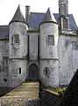
The towers and drawbridge
-

The château entrance
See also
References
External links
| Wikimedia Commons has media related to Estrée-Blanche. |
- Estrée-Blanche on the Quid website (French)