Estivareilles, Allier
| Estivareilles | |
|---|---|
|
Lantern of the dead | |
 Estivareilles | |
|
Location within Auvergne region  Estivareilles | |
| Coordinates: 46°25′34″N 2°37′10″E / 46.4261°N 2.6194°ECoordinates: 46°25′34″N 2°37′10″E / 46.4261°N 2.6194°E | |
| Country | France |
| Region | Auvergne |
| Department | Allier |
| Arrondissement | Montluçon |
| Canton | Hérisson |
| Intercommunality | Val de Cher |
| Government | |
| • Mayor (2008–2014) | Georges Pailleret |
| Area1 | 11.27 km2 (4.35 sq mi) |
| Population (2009)2 | 1,085 |
| • Density | 96/km2 (250/sq mi) |
| INSEE/Postal code | 03111 / 03190 |
| Elevation |
179–348 m (587–1,142 ft) (avg. 230 m or 750 ft) |
|
1 French Land Register data, which excludes lakes, ponds, glaciers > 1 km² (0.386 sq mi or 247 acres) and river estuaries. 2 Population without double counting: residents of multiple communes (e.g., students and military personnel) only counted once. | |
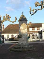
Estivareilles is a commune in the Allier department in central France. It lies about 10km north of Montluçon on the right-hand side of the Cher river. There is a Lavoir (a public washing basin), a lantern of the dead and a church from the nineteenth century.
Population
| Historical population | ||
|---|---|---|
| Year | Pop. | ±% |
| 1962 | 728 | — |
| 1968 | 863 | +18.5% |
| 1975 | 939 | +8.8% |
| 1982 | 1,101 | +17.3% |
| 1990 | 1,104 | +0.3% |
| 1999 | 1,033 | −6.4% |
| 2008 | 1,046 | +1.3% |
| 2009 | 1,085 | +3.7% |
See also
References
External links
- The official web site of the mayor of Estivareilles
- Estivareilles page at the National Geographical Institute
| Wikimedia Commons has media related to Estivareilles, Allier. |