Escurolles
| Escurolles | ||
|---|---|---|
|
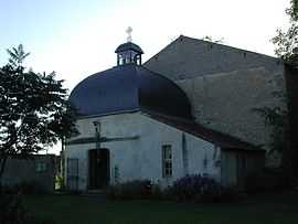
The church in Escurolles | ||
| ||
 Escurolles | ||
|
Location within Auvergne region  Escurolles | ||
| Coordinates: 46°08′39″N 3°15′58″E / 46.1442°N 3.2661°ECoordinates: 46°08′39″N 3°15′58″E / 46.1442°N 3.2661°E | ||
| Country | France | |
| Region | Auvergne | |
| Department | Allier | |
| Arrondissement | Vichy | |
| Canton | Escurolles | |
| Intercommunality | Bassin de Gannat | |
| Government | ||
| • Mayor (2008–2014) | Jean-Pierre Moulin | |
| Area1 | 13.27 km2 (5.12 sq mi) | |
| Population (2008)2 | 721 | |
| • Density | 54/km2 (140/sq mi) | |
| INSEE/Postal code | 03109 / 03110 | |
| Elevation |
287–323 m (942–1,060 ft) (avg. 320 m or 1,050 ft) | |
|
1 French Land Register data, which excludes lakes, ponds, glaciers > 1 km² (0.386 sq mi or 247 acres) and river estuaries. 2 Population without double counting: residents of multiple communes (e.g., students and military personnel) only counted once. | ||
.svg.png)
Escurolles is a commune in the Allier department in central France.
Population
| Historical population | ||
|---|---|---|
| Year | Pop. | ±% |
| 1962 | 602 | — |
| 1968 | 623 | +3.5% |
| 1975 | 617 | −1.0% |
| 1982 | 662 | +7.3% |
| 1990 | 668 | +0.9% |
| 1999 | 657 | −1.6% |
| 2008 | 721 | +9.7% |
See also
References
| Wikimedia Commons has media related to Escurolles. |