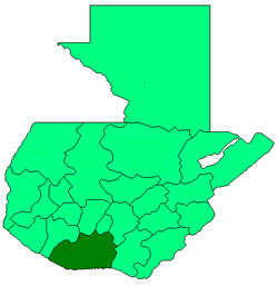
Escuintla Department
| Escuintla | |||
|---|---|---|---|
| Department | |||
| |||
 Escuintla | |||
| Coordinates: 14°17′52″N 90°47′13″W / 14.29778°N 90.78694°WCoordinates: 14°17′52″N 90°47′13″W / 14.29778°N 90.78694°W | |||
| Country |
| ||
| Department | Escuintla | ||
| Capital | Escuintla | ||
| Municipalities | 13 | ||
| Government | |||
| • Type | Departmental | ||
| Area | |||
| • Department | 4,384 km2 (1,693 sq mi) | ||
| Population (Census 2002)[1] | |||
| • Department | 538,746 | ||
| • Urban | 256,972 | ||
| • Ethnicities | Ladino, Poqomam | ||
| • Religions | Roman Catholicism, Evangelicalism | ||
| Time zone | -6 | ||
| ISO 3166 code | GT-ES | ||
.png)
Escuintla (Spanish pronunciation: [esˈkwintla]) is one of the 22 departments of Guatemala. Its capital is the city of Escuintla. The department of Escuintla covers an area of 4,384 km² and is situated in the coastal lowland region to the South of Guatemala-City, bordered by the Pacific Ocean. Escuintla produces about 43 percent of gross domestic product of Guatemala. It is statistically the department, province or region in Mesoamerica with the lowest unemployment and extreme poverty.
Municipalities
- Escuintla
- Guanagazapa
- Iztapa
- La Democracia
- La Gomera
- Masagua
- Nueva Concepción
- Palín
- San José
- San Vicente Pacaya
- Santa Lucía Cotzumalguapa
- Siquinalá
- Tiquisate
Museums
Museo Regional de Arqueología de la Democracia
Notes
- ↑ "XI Censo Nacional de Poblacion y VI de Habitación (Censo 2002)". Insituto Nacional de Estadística (INE). 2002.