Ermera District
| Ermera | ||
|---|---|---|
| District | ||
|
Ermera | ||
| ||
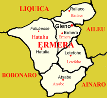
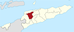 Map of East Timor highlighting Ermera District | ||
| Coordinates: 8°50′S 125°23′E / 8.833°S 125.383°ECoordinates: 8°50′S 125°23′E / 8.833°S 125.383°E | ||
| Country |
| |
| Capital | Gleno | |
| Subdistricts |
Atsabe, Ermera, Hatulia, Letefoho, Railaco | |
| Area | ||
| • Total | 768 km2 (297 sq mi) | |
| Area rank | 10th | |
| Population (2010) | ||
| • Total | 114,635 | |
| • Rank | 2nd | |
| • Density | 150/km2 (390/sq mi) | |
| • Density rank | 2nd | |
| Households | ||
| • Total | 21,165 (as of 2004) | |
| • Rank | 3rd | |
| Time zone | UTC+9 | |
| ISO 3166 code | TL-ER | |

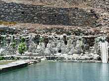
Ermera is one of the districts of East Timor, located in the west-central part of the country. It has a population of 103,169 (Census 2004) and an area of 746 km2. Its capital is Gleno, which is located 30 km to the southwest of the national capital, Dili. The city of Ermera, also known as Vila Ermera, lies 58 km from the capital along the same road. In Marobo (Subdistrict Atsabe) are the remains of a hot springs bath from colonial times. The pool is still in use.[1]
Ermera is one of only two land-locked districts in East Timor, the other being Aileu. It borders Liquiçá to the north, Dili to the northeast, Aileu to the east, Ainaro to the southeast, and Bobonaro to the west.
The district was identical to that of the same name in Portuguese Timor. Its subdistricts are Atsabe, Ermera, Hatulia, Letefoho and Railaco.
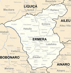 Subdivisions of Ermera |
 Cities of Ermera |