Erlenbach–Winkel
The site of the prehistoric settlement
Erlenbach–Winkel is one of the 111 serial sites of the UNESCO World Heritage Site Prehistoric pile dwellings around the Alps, of which are 56 located in Switzerland.[1][2]
Geography
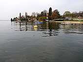
The site is located on Zürichsee lakeshore in Winkel, a locality of the municipality of Erlenbach in the Canton of Zürich in Switzerland. Because the lake has grown in size over time, the original piles are now around 4 metres (13 ft) to 7 metres (23 ft) under the water level of 406 metres (1,332 ft). The settlement comprises 0.92 hectares (2.27 acres), and the buffer zone including the lake area comprises 49.1 hectares (121.33 acres) in all.
Description
From the Early Bronze Age (20th/19th centuries BC) are numberours finds and ground plans of Corded Ware houses of particular interest. The latter are associated with material from the final phase of the Corded Ware Culture marking a hiatus of 600 years in the period of constructing pile dwellings north of the Alps until the Early Bronze Age. In a European context, the house constructions are of particular interest, because the Corded Ware Culture is defined mainly by its grave finds, whereas settlements are usually missing from the archaeological record.[3]
Swiss inventory of cultural property of national and regional significance
As well as being part of the 56 Swiss sites of the UNESCO World Heritage Site Prehistoric pile dwellings around the Alps, the settlement is also listed in the Swiss inventory of cultural property of national and regional significance as a Class object.[4]
See also
Literature
- Peter J. Suter, Helmut Schlichtherle et al.: Pfahlbauten – Palafittes – Palafitte. Palafittes, Biel 2009. ISBN 978-3-906140-84-1.
- Beat Eberschweiler: Ur- und frühgeschichtliche Verkehrswege über den Zürichsee: Erste Ergebnisse aus den Taucharchäologischen Untersuchungen beim Seedamm. In: Mitteilungen des Historischen Vereins des Kantons Schwyz, Volume 96, Schwyz 2004.[5]
External links
References
|
|---|
| | | | Settlements | | |
|---|
| | Islands | |
|---|
| | Rivers | |
|---|
| | Valleys | |
|---|
| | Mountains | |
|---|
| | Landmarks | |
|---|
| | Transportation | |
|---|
| | People | |
|---|
|
Coordinates: 47°17′49.91″N 8°35′46.31″E / 47.2971972°N 8.5961972°E / 47.2971972; 8.5961972

