Erateini
| Erateini Ερατεινή | |
|---|---|
 | |
 Erateini | |
|
Location within the region | |
| Coordinates: 38°22′N 22°14′E / 38.367°N 22.233°ECoordinates: 38°22′N 22°14′E / 38.367°N 22.233°E | |
| Country | Greece |
| Administrative region | Central Greece |
| Regional unit | Phocis |
| Municipality | Dorida |
| Municipal unit | Tolofon |
| Time zone | EET (UTC+2) |
| • Summer (DST) | EEST (UTC+3) |
| Vehicle registration | ΑΜ |
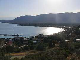
Erateini (Greek: Ερατεινή) is a village in the southern part of Phocis, Greece. It was the municipal seat of the municipality of Tolofon. Erateini is situated on the Gulf of Corinth, 14 km west of Galaxidi, 19 km south of Lidoriki, 23 km southwest of Amfissa and 35 km east of Nafpaktos. The Greek National Road 48 (Antirrio - Nafpaktos - Delphi - Livadeia) passes through the village. In 2001, Erateini had a population of 726.
Population
| Year | Population |
|---|---|
| 1981 | 529 |
| 1991 | 572 |
| 2001 | 726 |
External links
See also
References
| ||||||||||||||||||