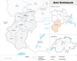
Entlebuch District
| Entlebuch District Wahlkreis Entlebuch | |
|---|---|
| District | |
 | |
| Country |
|
| Canton |
|
| Capital | Schüpfheim |
| Area | |
| • Total | 424.43 km2 (163.87 sq mi) |
| Population (2013) | |
| • Total | 22,976 |
| • Density | 54/km2 (140/sq mi) |
| Time zone | CET (UTC+1) |
| • Summer (DST) | CEST (UTC+2) |
| Municipalities | 9 |
Entlebuch District was one of the five Ämtern, or districts, of the German-speaking Canton of Lucerne, Switzerland. Its capital is the village of Schüpfheim. In 2013 the name was changed from Amt Entlebuch to Wahlkreis Entlebuch as part of a reorganization of the Canton. A sixth Wahlkreis was created, but in Entlebuch everything else remained essentially unchanged.
History
The area of the district is equivalent to the historical region of Entlebuch. At a total area of 395 km² it is dominated by the main valley of the Kleine Emme. The valley had been acquired by the house of Habsburg in 1300. In the later 14th century, the Entlebuch was in conflict with Obwalden over the right to alpine pastures, culminating in the Battle of Sörenberg in 1380. As a result of the conflict, the Entlebuch sought an alliance with Lucerne and in 1385 became a subject territory of that city. The region was long known as the "poorhouse of Switzerland" (also as the "Wild West of Lucerne") and is struggling for economic independence even today. In 2001 UNESCO accepted the region of Entlebuch to become part of the World Network of Biosphere Reserves, in which conservation of the natural and cultural landscape is coupled with strengthening the local economy.
Municipalities
Entlebuch consists of the following municipalities:
| Municipality | Population (31 December 2013)[1] |
Area, km² |
|---|---|---|
| Doppleschwand | 746 | 6.95 |
| Entlebuch | 3,290 | 56.90 |
| Escholzmatt-Marbach | 4,323 | 106.37 |
| Flühli | 1,874 | 108.24 |
| Hasle | 1,732 | 40.33 |
| Romoos | 674 | 37.24 |
| Schüpfheim | 4,093 | 38.37 |
| Werthenstein | 2,007 | 15.80 |
| Wolhusen | 4,237 | 14.3 |
| Total | 22,976 | 424.43[2] |
Mergers and name changes
- On 1 January 2013 the former municipalities of Escholzmatt and Marbach (LU) merged to form the new municipality of Escholzmatt-Marbach. The municipality of Wolhusen moved from the Sursee District to the Entlebach District.[3][4]
See also
References
- ↑ Swiss Federal Statistics Office – STAT-TAB Ständige und Nichtständige Wohnbevölkerung nach Region, Geschlecht, Nationalität und Alter (German) accessed 18 August 2014
- ↑ LUSTAT-Canton of Lucerne Statistical Office as of 2000 survey, (German) accessed 25 August 2009
- ↑ Nomenklaturen – Amtliches Gemeindeverzeichnis der Schweiz (German) accessed 9 February 2013
- ↑ Amtliches Gemeindeverzeichnis der Schweiz published by the Swiss Federal Statistical Office (German) accessed 2 January 2013
External links
- District of Entlebuch in German, French and Italian in the online Historical Dictionary of Switzerland.