Enge (Zürich)
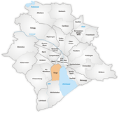
Enge is a quarter in the district 2 in Zürich.
History
It was formerly a municipality of its own, having been incorporated into Zürich in 1893. The quarter has a population of 8,375 distributed on an area of 2.4 km².
Transportation
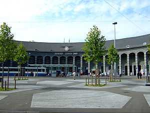
Zürich Enge railway station is a stop of the Zürich S-Bahn on the lines S2, S8, S21 and S24.
Notable people
- Lydia Welti-Escher (1858–1891), patron of the arts and founder of the Gottfried Keller Stiftung
- Gottfried Keller (1819–1890), Swiss poet
Cultural Heritage
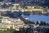
Located on the then swamp land between Limmat river and Zürichsee around Sechseläutzenplatz on small islands and peninsulas in Zürich, Prehistoric pile dwellings around Zürichsee were set on piles to protect against occasional flooding by the Linth and Jona rivers. Zürich–Enge Alpenquai is located on Zürichsee lakeshore in Enge, a locality of the municipality of Zürich. It was neighboored by the settlements at Kleiner Hafner and Grosser Hafner on a then peninsula respectively island in the effluence of the Limmat river, within an area of about 0.2 square kilometres (49.42 acres) in the city of Zürich. As well as being part of the 56 Swiss sites of the UNESCO Worl Heritage Site Prehistoric pile dwellings around the Alps,[1][2] the settlement is also listed in the Swiss inventory of cultural property of national and regional significance as a Class object, as well as the Arboretum including the Voliere Zürich,[3] being part of the so-called Quaianlagen.[4]
References
- ↑ "Prehistoric Pile Dwellings in Switzerland". Swiss Coordination Group UNESCO Palafittes (palafittes.org). Retrieved 2014-12-10.
- ↑ "World Heritage". palafittes.org. Retrieved 2014-12-10.
- ↑ "Voliere Zürich – Vogelpflegestation" (in German). Voliere Zürich. Retrieved 2014-12-28.
- ↑ "A-Objekte KGS-Inventar". Schweizerische Eidgenossenschaft, Amt für Bevölkerungsschutz. 2009. Retrieved 2014-12-10.
| Wikimedia Commons has media related to Enge. |
Coordinates: 47°21′49″N 8°31′52″E / 47.36361°N 8.53111°E
| ||||||||