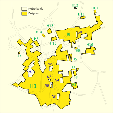
Enclave and exclave
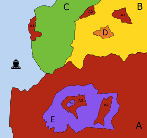
- A (red):
- possesses 3 exclaves (A1, A2 and A3): it is impossible to go from the main part A to any of these parts going only through territory of A; however:
- A1 and A2 are not enclaves: neither of them is surrounded by a "foreign" territory;
- A3 is an enclave: it is totally surrounded by B;
- contains 1 enclave (E): "foreign" territory totally surrounded by territory of A;
- possesses 2 counter-enclaves, or second-order enclaves (A4 and A5): territories belonging to A which are encroached inside the enclave E;
- contains 1 counter-counter-enclave, or third-order enclave (E1).
- possesses 3 exclaves (A1, A2 and A3): it is impossible to go from the main part A to any of these parts going only through territory of A; however:
- B (yellow):
- contains 2 enclaves (A3 and D).
- C (green):
- continuous territory.
- D (orange):
- is an enclaved territory: it is territorially continuous, but its territory is totally surrounded by a single "foreign" territory (B).
- E (purple):
- is an enclaved territory: it is encroached inside A;
- contains 2 enclaves (A4 and A5), which are counter-enclaves of A;
- possesses 1 counter-enclave (E1), which is a counter-counter-enclave as viewed by A and contained within A5.
An enclave is any portion of a state that is entirely surrounded by the territory of one other state.[1] An exclave is a portion of a state geographically separated from the main part by surrounding alien territory.[2] Many enclaves are also exclaves.
Enclave is sometimes used improperly to denote a territory that is only partly surrounded by another state.[1] When such a territory additionally borders a body of water that is not enclosed by a different state, it is termed a pene-enclave or "practical" enclave. Coastal examples include Gibraltar, Ceuta, Alaska, Kaliningrad Oblast, Musandam and Cabinda.
For illustration, in the figure (right), A1 is a pene-enclave (attached to C but also bounded by water). Although A2 is an exclave of A, it cannot be classed as an enclave because it shares borders with B and C. The territory A3 is both an exclave of A and an enclave from the viewpoint of B.
Origin and usage
The word enclave is French and first appeared in the mid-15th century as a derivative of the verb enclaver (1283), from the colloquial Latin inclavare (to close with a key).[3] Originally, it was a term of property law that denoted the situation of a land or parcel of land surrounded by land owned by a different owner, and that could not be reached for its exploitation in a practical and sufficient manner without crossing the surrounding land.[4] In law, this created a servitude[5] of passage for the benefit of the owner of the surrounded land.
Later, the term enclave began to be used also to refer to parcels of countries, counties, fiefs, communes, towns, parishes, etc. that were surrounded by alien territory. This French word eventually entered the English and other languages to denote the same concept although local terms have continued to be used. In India, the word "pocket" is often used as a synonym for enclave (such as "the pockets of Puducherry district").[6] In British administrative history, subnational enclaves were usually called detachments or detached parts, and national enclaves as detached districts or detached dominions.[7] In English ecclesiastic history, subnational enclaves were known as peculiars (see also Royal Peculiar).
The word exclave, modeled on enclave,[8] is a logical extension of the concept of enclave.
Characteristics

Enclaves may have been created for a variety of historical, political or geographical reasons. Some areas have been left as enclaves by changes in the course of a river.
In the feudal system, the ownership of feudal domains was often transferred or partitioned, either through purchase and sale or through inheritance, and often such domains were or came to be surrounded by other domains. In particular, this state of affairs persisted until the 19th century in the Holy Roman Empire, and these domains (principalities etc.) came to have many of the characteristics of sovereign states.
Since living in a national enclave can be very inconvenient and many agreements have to be made by both countries about mail addresses, power supply or passage rights, enclaves tend to be eliminated and many cases that existed before have now been removed. The governments of India and Bangladesh have been pressed to resolve the complex system of enclaves along their border – persons in these enclaves have complained of being effectively stateless.[9] In 2011, India and Bangladesh signed a leasehold agreement regarding the Tin Bigha Corridor.
True enclaves
A true enclave is a territory over which a nation is sovereign, but which cannot be reached without passing through territory of the single foreign nation that surrounds it. Two examples are Büsingen, a true exclave of Germany, and Campione d'Italia, a true exclave of Italy, both surrounded by Switzerland.
A historical example was West Berlin before the reunification of Germany, which was a de facto West German exclave, being enclaved by East Germany. (Also, 12 small exclaves of West Berlin, such as Steinstücken, were separated from the city, some by only a few meters.) All of Berlin was ruled de jure by the four Allied powers; however, the East German government and the Soviet Union treated East Berlin as an integral part of East Germany.
Most of the true national-level enclaves now existing are in Asia and Europe. While subnational enclaves are numerous the world over, there are only a few national-level enclaves in Africa, Australia and the Americas (each such enclave being surrounded by the territorial waters of another country).
Enclaved countries
Some countries in their own right, completely surrounded by another country, are said to be enclaves. They are not enclaves as such, as according to the definition, an enclave is a portion of a country, and not an entire state. Three such enclaved countries are:
- The republic of San Marino, enclaved within Italy
- Vatican City, enclaved within the city of Rome, Italy
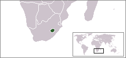
- The Kingdom of Lesotho, enclaved within South Africa
The principality of Monaco is not an enclave, although it only borders France, because it also possesses a coastline and territorial waters; thus, it is not completely surrounded by another country. Similarly, The Gambia is not an enclave.
Historically, four of the Black homelands or Bantustans of South Africa were granted nominal independence, unrecognized internationally, by the Nationalist government from 1976 until their reabsorption in 1994. Others remained under government rule from 1948 to 1994. Being heavily partitioned, various parts of these Bantustans were true enclaves.
The USA's constitutional principle of tribal sovereignty treats federally-recognized Indian reservations as quasi-independent enclaves. The same would apply for Indian reserves in Canada and Aboriginal reserves in Australia.
Temporary enclaves
The Scottish Court in the Netherlands, at Camp Zeist near Utrecht, was temporarily declared as sovereign territory of the United Kingdom under Scots law for the duration of the trial of those accused in the Lockerbie bombing, and was therefore an exclave of the United Kingdom, and of Scotland, and an enclave within the Netherlands. This was also so during the appeal against the conviction. The court was first convened in 1999, and the land returned to the Netherlands in 2002.
Related constructs and terms
Exclaves
In the figure above, A3 is both an enclave and an exclave. A2 is an exclave of A, but it is not an enclave, because it borders both B and C. The singular territory D, although an enclave, is not an exclave.
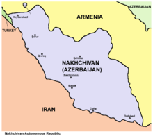
- Nakhichivan, which borders Turkey, Armenia and Iran, is an exclave of Azerbaijan.[10]
- Llívia is an exclave of Spain surrounded by France.
- Campione d'Italia is an exclave of Italy surrounded by Switzerland.
- Büsingen am Hochrhein is an exclave of Germany surrounded by Switzerland. The shortest distance from Büsingen's borders to the main portion of German territory is only about 700 metres (about 2,300 ft).
Subnational enclaves and exclaves
Sometimes, administrative divisions of a country, for historical or practical reasons, caused some areas to belong to one division while being attached to another.
- Dadra, enclaved within the state of Gujarat, part of Dadra and Nagar Haveli in India
- Pondicherry district, of the Union Territory of Puducherry, is made of 12 non-contiguous parts,[11] many of them true enclaves entirely surrounded by the state of Tamil Nadu. Before Pondicherry, along with the other territories of French India, was absorbed into India in 1954, they were enclaved within the Union of India, and before that the British Raj. Also a legacy of the French colonial period, the Mahe district is made of 3 non-contiguous parts enclaved within the state of Kerala.
- From 1947 to 1971, Bangladesh was a part of Pakistan as its East Pakistan exclave, separated from West Pakistan by 1,760 kilometers (1,100 miles) of India. In 1971 it eventually gained independence during the Bangladesh Liberation War.
- Before 1974, and especially before 1844, there were many exclaves of counties in England and Wales.
- The counties of Scotland before reorganisation in 1889 included dozens of exclaves. This was especially notable in the case of Cromartyshire, which was split into at least nine parts spread across Ross-shire.
- The French department of Pyrénées-Atlantiques, in the southwest of France, surrounds two enclaves of the neighbouring department of Hautes-Pyrénées.
- The French department of Vaucluse has a rather large exclave to its southeast within the Drôme department — the canton of Valréas (historically known as Enclave des Papes).
- San Colombano al Lambro is an exclave of the province of Milan at the junction beteween the Pavia and Lodi provinces. The exclave arose when the province of Lodi was carved out of the province of Milan, but a referendum in San Colombano indicated the locals' wish to stay in Milan. As a result, the commune is the only wine-producing area in the mostly urbanized province of Milan.
- In the United States:
- A portion of Ellis Island is an exclave of New York City within the boundaries of Jersey City, and therefore of New York State within the boundaries of New Jersey.
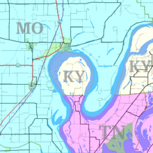
- The Kentucky Bend exists because of a meander of the Mississippi River.
- In 1970, Unigov in the State of Indiana consolidated Marion County and the City of Indianapolis into a single entity but excluded four autonomous cities within geographical Marion County that do not participate in the consolidated city-county government of Indianapolis. The autonomous cities of Beech Grove, Southport and Speedway are enclaves within the city of Indianapolis, i.e., they are completely surrounded by the city. The remaining autonomous city, Lawrence, extends to the geographic county line and therefore is not enclaved.
- Jeddito, Arizona lies within a 121-square-kilometre (47 sq mi) exclave of the Navajo Nation. This exclave is surrounded by territory of the Hopi Reservation, which is itself surrounded by the Navajo Nation.
- In Canada, East York became an exclave of the Township of York when the township of North York was established in 1922. East York later became a separate township in 1924. Those three were amalgamated into Toronto in 1998.
Enclaves within enclaves
It is possible for an enclave of one country to be completely surrounded by a part of another country that is itself an enclave of the first country.
- The Dutch municipality of Baarle-Nassau has seven exclaves in two exclaves of the Belgian municipality of Baarle-Hertog.
- The complex of enclaves at Cooch Behar district includes 24 second-order enclaves and one small third-order enclave called Dahala Khagrabari #51: a piece of India within Bangladesh, within India, within Bangladesh.
- Nahwa of the United Arab Emirates is surrounded by Madha, an exclave of Oman within the U.A.E.
- The Portuguese town of Estremoz is made up of two civil parishes (freguesias): the small Santo André and the big Santa Maria. Santo André corresponds to the old town (located inside the medieval walls), but excluding the citadel, which is an enclave inside the old town; the citadel belongs to Santa Maria, which also includes the entire new town (outside the walls) and the vast rural area around it. Thus, Santa Maria has an enclave (Santo André, the old town) with a second-order enclave inside it (the citadel).[12]
Ethnic enclaves
An ethnic enclave is a community of an ethnic group inside an area in which another ethnic group predominates. Ghettos, Little Italys, barrios and Chinatowns are examples. These areas may have a separate language, culture and economic system.
- Székely Land is a Hungarian ethnic enclave within Romania, with its people calling themselves székely. Originally, the name Székely Land denoted an autonomous region within Transylvania. It existed as a legal entity from medieval times until the Austro-Hungarian Compromise of 1867, when the Székely and Saxon seats were dissolved and replaced by the county system. Along with Transylvania, it became a part of Romania in 1920, according with the Treaty of Trianon signed on 4 June 1920 at the Grand Trianon Palace in Versailles, France. In 1938–1940, during World War II, post-Trianon Hungary temporarily expanded its territory and included some additional territories that were formerly part of pre-war Kingdom of Hungary, under Third Reich auspices, the Second Vienna Award. It was later reduced to boundaries approximating those of 1920 by the peace treaties signed after World War II at Paris, in 1947. The area was called Magyar Autonomous Region between September 8, 1952 and February 16, 1968 a Hungarian autonomous region within Romania, and today there are territorial autonomy initiatives to reach a higher level of self-governance for this region within Romania.
- The 2008 film Silent Light depicts a Mennonite Flemish sect living within the Mexican state of Chihuahua, who speak a dialect called Plautdietsch.[13]
- There are several Serb enclaves in Kosovo where the institutions of Kosovo aren't fully operational due to disputes.
"Practical" enclaves, exclaves and inaccessible districts
Pene-enclaves and pene-exclaves are regions that are not conterminous with the main land region, border only one alien territory, and are not entirely surrounded by alien land or alien territorial waters. Hence, they are enclaves or exclaves for practical purposes, without meeting the strict definition.
Many pene-exclaves partially border the sea or another body of water, which comprises their own territorial waters (i.e., they are not surrounded by other nations' territorial waters). Alaska is the largest pene-exclave in the world. Because they border their own territorial waters in addition to a land border with another country, they are not true exclaves. Still, one cannot travel to them on land without going through another country.
- Kaliningrad Oblast is a federal subject of Russia (an oblast), a pene-exclave situated on the Baltic coast.
- Cabinda (also spelled Kabinda, formerly Portuguese Congo) is a pene-exclave and a province of Angola on the Atlantic coast of southwestern Africa.
- Oecusse, a district on the northwestern side of the island of Timor, is a pene-exclave of East Timor.
- Ceuta and Melilla are Spanish pene-exclaves on the Mediterranean coast of Morocco.
- Temburong is a Bruneian pene-exclave surrounded by Malaysia.
- The Northwest Angle in Minnesota is geographically separated from the rest of the state (and United States) by Lake of the Woods and is only accessible on land through Canada.
- Point Roberts, Washington, is an unincorporated community in Whatcom County—located on the southernmost tip of the Tsawwassen Peninsula, south of Delta, British Columbia, Canada—that can be reached by land from the rest of the United States only by traveling through Canada.
- Ambergris Caye is a Belizean pene-exclave—south of Xcalak, Quintana Roo. It can be only accessible by travelling through the rest of Mexico.
- Vermont has two pene-exclaves with Canada. Province Point, a few kilometres to the northeast of the town of East Alburgh, Vermont, is the southernmost tip of a small promontory approximately 2 acres (1 ha) in size 45.013351°N 73.193257°W.[38] The promontory is cut through by the US-Canadian border; as such the area is a practical exclave of the United States contiguous with Canada. Similarly, the southern point of Province Island, 45°0'15"N 72°13'52"W, a small island mostly in the Canadian province of Quebec, crosses into the American state of Vermont. It is situated in Lake Memphremagog, near Newport, Vermont.
- Northern Ireland, one of the four countries that make up the United Kingdom, is bounded by the Republic of Ireland, the Irish Sea and the Atlantic Ocean.
Inaccessible districts are regions that are conterminous with the main land region but that are only easily accessible by going through a second country.
- The Spanish village of Os de Civís can only be accessed through the independent Principality of Andorra, as it is virtually isolated from the rest of Spain by mountains.
- The Kleinwalsertal Alpine valley in Vorarlberg, Austria can only be accessed by road from Germany, being separated from the rest of Austria by inaccessible high mountains traversed by no roads.
- Jungholz is a village, also in Austria (in Tyrol), which is surrounded by German territory except for one single point on the summit of Sorgschrofen, where it touches the rest of Austria. As with Kleinwalsertal, road access is only through Germany.
Conversely, a territory that is an exclave but does not function as one (instead functioning as an adjacent part of the main nation) is deemed a "quasi-exclave".(Robinson 1959)
Subnational "practical" enclaves, exclaves and inaccessible districts
- Although the Jervis Bay Territory, which occupies a coastal peninsula in Australia, is not part of the Australian Capital Territory, the laws of the ACT apply to it. It is administered by a department of the ACT government as an exclave of the ACT.[14]
- A strip of land around the southern edge of the Beecroft Peninsula in Australia is a pene-exclave of the Australian Capital Territory. This area on the northern side of Jervis Bay, opposite the Jervis Bay Territory, is part of the ACT. At the tip of the peninsula, this pene-exclave surrounds most of the grounds of the Point Perpendicular lighthouse, making those grounds a pene-exclave of the State of New South Wales.[15]
- The Romanian village of Nămoloasa (Galaţi county) can be accessed only through Vrancea County (where there is a bridge over the Siret river) because it is separated by the Siret River river from the rest of Galaţi county.
- The southern part of the Province of Venice, Veneto, can be reached directly from the rest of the province only by boat. By land it can be reached only traveling through the Province of Padua because territorial continuity with the main part of the province exists only through some unconnected islands and islets.
- It is physically impossible to drive from the northern half of County Leitrim in the Republic of Ireland to the southern half; the land area of the county is almost squeezed in two by Lough Allen on the west and the border with County Cavan on the east. The River Shannon (apart from where it forms part of the border between the two counties) runs within Leitrim from the Cavan border to Lough Allen, and there are no bridges over this Leitrim portion of the river, therefore making it impossible to cross from one side of the Shannon in Leitrim to the other without leaving the county. The best one can do is by travelling the R200 from the Leitrim side of the county border, passing into County Cavan into the village of Dowra and then taking the R207 and passing over the Shannon and back into County Leitrim, which involves a journey of 2.6 km (1.6 miles) outside of the county. Travelling around the west side of Lough Allen involves substantial travel though County Roscommon.[16]
- The community of East Kemptville, Nova Scotia, Canada, is part of the Municipality of Argyle, but it can only be reached by road from the rest of the municipality by travelling through the Municipality of Yarmouth or the Municipality of Shelburne. The latter route also requires travelling through the Municipality of Barrington.
- In the United States:
- Several portions of land on the New Jersey side of the Delaware River belong to Delaware. Within the Twelve-Mile Circle, Delaware's border extends to the low-water mark across the river, running from the proximate location of Claymont, Delaware and Logan Township, New Jersey to Augustine Beach, Delaware. South of the circle, the Delaware-New Jersey border follows the middle of the river and bay.
- The Eastern Shore of Virginia on the southern portion of the Delmarva Peninsula shares a border with Maryland but is only connected to the rest of Virginia by the Chesapeake Bay Bridge-Tunnel, which is part of U.S. Route 13. (Before the Bridge-Tunnel, a ferry provided the continuation of U.S. 13 at this point.)
- The city of Carter Lake, Iowa is separated from the rest of the state of Iowa by the Missouri River, which changed course during a flood in 1877, cutting the city off from the rest of the state and leaving an oxbow lake. It is now only accessible through Omaha, Nebraska.
- The Upper Peninsula of Michigan. It is separated from the rest of Michigan (the Lower Peninsula) by the Great Lakes and Wisconsin in the southwest, although the Mackinac Bridge links the two peninsulas together.
Extraterritoriality
Diplomatic missions, such as embassies and consulates, as well as military bases, are usually exempted from the jurisdiction of the host country, i.e., the laws of the host nation in which an embassy is located do not typically apply to the land of the embassy or base itself. This exemption from the jurisdiction of the host country is defined as extraterritoriality. Areas and buildings enjoying some forms of extraterritoriality are not true enclaves since, in all cases, the host country retains full sovereignty. In addition to embassies, some other areas enjoy a limited form of extraterritoriality.
Examples of this include:
- Pavillon de Breteuil in France, used by the General Conference on Weights and Measures.
- United Nations headquarters in the United States of America, used by the United Nations.
- United Nations Office at Geneva in Switzerland, used by the United Nations.
- INTERPOL headquarters in Lyon, France, used by INTERPOL
- NATO (political) headquarters near Evere in Haren, a part of the City of Brussels, Belgium.
- Headquarters Allied Command Operations (NATO) at the area designated as Supreme Headquarters Allied Powers Europe (SHAPE), North of Mons, Belgium
- Palazzo Malta and the Villa del Priorato di Malta, the headquarters of Sovereign Military Order of Malta in Rome. In addition to extraterritoriality, Italy recognizes the exercise by SMOM of all the prerogatives of sovereignty in its headquarters. Therefore, Italian sovereignty and SMOM sovereignty uniquely coexist without overlapping.[17]
- Extraterritorial properties of the Holy See in Rome and surroundings.
- By treaty of 2 November 1929, Czechoslovakia obtained the lease for 99 years of two plots of land (in the Moldauhafen and in the Saalehafen), both within the perimeter of the free port of Hamburg. Another plot, in the Peutehafen, was purchased by the Czechoslovak government in 1929; this plot lies just outside of the free-port perimeter.[18][19][20][21]
- Saalehafen – approximately 2 ha of land on Hallesches Ufer, on the southeastern bank of the Saalehafen
- Moldauhafen – approximately 0.5 ha of land on Dresdener Ufer, on the southeastern bank of the Moldauhafen
- Peutehafen – the narrow peninsula between the Peutekanal and the Peutehafen dock, comprising 8.054 ha of land and 0.5 ha of water surface
- In Szczecin, Poland, a similar provision existed following the Treaty of Versailles for Czechoslovakia to have access to the harbor, which until the end of World War II was located in Germany. From 1945, when Szczecin became part of Poland, Czechoslovakia possessed no extraterritorial rights there.[22] It appears that the German concession ceased at the end of the war and that no successor paid attention to the pre-war rights that Czechoslovakia had under the Versailles Treaty. Neither the Polish nor the occupying Russians appear to have assumed any of Germany's pre-war liabilities. Czechoslovakia gave up the rights to its territory in Szczecin under an agreement signed on 13 January 1956.[23]
- Saimaa Canal: the longitudinal half of the canal in Russia is leased by Finland until 2063. Russian law is in principle valid, but in reality Finland maintains the area.
Land owned by a foreign country
Some areas of land in a country are owned by another country and in some cases it has special privileges, such as being exempt from taxes. These lands are not enclaves and do not have extraterritoriality since, in all cases, there is no transfer of sovereignty.
Examples of this include:
- Napoleon's original grave in Longwood, Saint Helena, owned by France.[24]
- The Brest memorial, in Brest, France, has been owned by the United States since the aftermath of World War I.
- Victor Hugo's house in St Peter Port, Guernsey, owned by the city of Paris.[25]
- The Normandy American Cemetery and Memorial in Normandy, France, which contains the graves of 9,386 American military dead, most of whom died during the landings and ensuing operations of World War II, owned by the United States of America.
- Pointe du Hoc, 13-hectare site of a memorial and museum dedicated to the World War II Normandy landing at Omaha Beach, transferred by France to American control on 11 January 1979.[26]
- About 24 m2 (260 sq ft) of land that surrounds the Suvorov memorial near Göschenen in central Switzerland, owned by Russia.
- The Vimy Memorial in France, which commemorates the Battle of Vimy Ridge. The French government permanently granted a land area of about 91 ha (220 acres) to Canada as a war memorial in 1922 in recognition of Canada's military contributions in World War I in general and at Vimy Ridge in particular.[27]
- Two cemeteries on the Outer Banks of North Carolina, United States, one on Ocracoke Island and one on Hatteras Island in the town of Buxton, are owned by the United Kingdom. Both contain the graves of British seamen whose bodies washed ashore after World War II U-Boat attacks that occurred on 10 April (San Delfino – one body) and 11 May 1942 (HMT Bedfordshire – 5 bodies).[28] Four graves are at Ocracoke and two at Buxton; three of the bodies were never identified, one of which could be that of a Canadian seaman.[29] The plot of land at Ocracoke "has been forever ceded to England" and is maintained by the U.S. Coast Guard.[30] The plot was leased to the Commonwealth War Graves Commission for as long as the land remained a cemetery.[29] The graves on Hatteras Island are maintained by the U.S. National Park Service.[31]
- The Captain Cook Monument at Kealakekua Bay and about 25 square feet (2.3 m2) of land around it in Hawaii, United States, the place where James Cook was killed in 1779, is owned by the United Kingdom.[32][33][34][35] An historian on the occasion of the monument's 50th anniversary recorded in 1928 that the white stone "obelisk monument [was] erected to the memory of Captain Cook, about 1876, and on land deeded outright to the British Government by Princess Likelike, sister of King Kalakaua, about the same year, so that that square is absolute British Territory."[36] Hawaii was a sovereign nation at the time. According to a recent writer, "The land under the monument was deeded to the United Kingdom in 1877 and is considered as sovereign non-embassy land owned by the British Embassy in Washington DC. ... the Hawaiian State Parks agency maintained that as sovereign British territory it was the responsibility of the UK to maintain the site."[37]
- Tihuinza in Peru. Land owned by Ecuador without sovereignty.
- Argentine Military Cemetery in Falkland Islands. Land owned by Argentina without sovereignty.
- The land under the John F. Kennedy memorial at Runnymede, United Kingdom, is widely thought to have been granted to the United States of America by the John F. Kennedy Memorial Act 1964[38] (an Act of the UK Parliament). However, the Act grants to the United States "an estate in fee simple absolute", which is a form of title under English law, and the site remains under the sovereignty of the United Kingdom.[39]
- The Tomb of Suleyman Shah (the burial place of Suleyman Shah, the grandfather of Osman I, the founder of the Ottoman Empire) situated in Aleppo Governorate, Syria, is the property of Turkey. Article 9 of the Treaty of Ankara signed between France and Turkey in 1921, provides that the tomb "shall remain, with its appurtenances, the property of Turkey, who may appoint guardians for it and may hoist the Turkish flag there".[40]
Unusual cross-border transport channels
National railway passing through another state's territory
Changes in borders can make a railway that was previously located solely within a country traverse the new borders. Since diverting a railway is expensive, this arrangement may last a long time. This may mean that doors on passenger trains are locked and guarded to prevent illicit entry and exit while the train is temporarily in another country. Borders can also be in the "wrong" place, forcing railways into difficult terrain.
Examples include:
- Salzburg to Innsbruck (Austria) (passes Rosenheim, Germany). A railway line within Austria exists as well, but trains take about 1.5 hours longer than across German territory.
- Trains from Neugersdorf, Saxony to Zittau pass Czech territory at Varnsdorf, while Czech trains from Varnsdorf to Chrastava pass through German territory at Zittau, and then a small part of Polish territory near the village of Porajów.
- Trains from Görlitz to Zittau, Germany, pass the border river Neisse several times (see Oder–Neisse line); the train station for Ostritz, Germany, lies in Krzewina Zgorzelecka, Poland.
- Belgrade–Bar railway crosses into Bosnia and Herzegovina for 9 kilometres (5.6 mi), between stations Zlatibor and Priboj (both in Serbia). There is one station, Štrpci, but there are no border crossing facilities and trains do not call at the station.
- The Knin – Bihać railway between Croatia and Bosnia is split by the Croatian–Bosnian border several times. Similarly, the Savski Marof – Imeno railway was split by the Slovenian–Croatian border several times.
- The local trains on the Burgenlandbahn in Austria cross the area of Hungary at Sopron. During the era of the Iron Curtain, the trains had their doors locked as they traversed Hungarian territory.
- The line from Ventimiglia to Limone Piemonte, Italy, via Breil-sur-Roya, France.
- The Hochrheinbahn (Upper Rhine Railway) from Basel via Waldshut to Schaffhausen is part of the Deutsche Bahn network, and is mostly in Germany, but the two ends are in Switzerland and it is only connected with the rest of the German railway network via Switzerland. At both Basel and Schaffhausen the railway has extraterritorial status: one can travel by train to and from the rest of Germany without going through Swiss customs. See Basel Badischer Bahnhof.
- Similarly, during the Cold War, underground lines in West Berlin ran under parts of East Berlin. Ghost stations (German: Geisterbahnhöfe) were stations on Berlin's U-Bahn and S-Bahn metro networks that were closed during this period of Berlin's division.
- The Belgian Vennbahn (now closed) lies on a narrow strip of Belgian territory running through Germany, creating five German exclaves.
- The railway between France and Italy briefly leaves France to enter Monaco in a 150 metre tunnel before entering France once more.
- The former Soviet Central Asian Republics have numerous examples.
- Semikhody – Chernihiv line of Ukraine passes through Belarus territory.[41]
- Druzhba – Vorozhba line of Ukraine passes through Russian territory.[41]
- In 2009, Russia and Kazakhstan agreed to transfer ownership of a crossborder section of line.
- Lučenec – Veľký Krtíš line in Slovakia passes through Hungary from Ipolytarnóc to Nógrádszakál.
- A very short length of the Syrian Homs–Tripoli line crosses the border into Lebanon. This happens because the railway was built before this border was defined.
- Bolivia is landlocked and has no access to the sea, but a rail route runs through Chile from La Paz to the port of Arica on the Pacific Ocean. The rail route was built by Chile under the Treaty of Peace and Friendship of 1904 between Chile and Bolivia, with the Bolivian section transferred to Bolivia after 15 years. Bolivia enjoyed duty-free use of the railway and the ports connected.
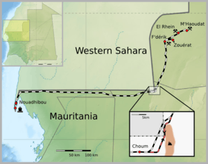
- Due to inability to agree in 1963 on a shorter route through easy terrain, the iron ore railway in Mauritania originally had to use a longer route through a tunnel (built through 2 km of solid granite) near Choum to avoid the territory of Spanish Sahara. The tunnel is no longer in use and trains now use the shorter route through 5 km of Western Saharan territory controlled by the Polisario Front.
- The shortest and straightest route for a proposed east–west high-speed railway in Austria through Linz, Salzburg and Innsbruck would pass under some mountains belonging to Germany.
- In 2012, a railway route from Angola proper to the enclave of Cabinda has to cross not only the Congo River but also the territory of the Democratic Republic of the Congo.
- In 2013, the shortest railway route from coal mines at Tete to a port at Nacala passes through Malawi. A route through all-Mozambique territory is roundabout.
- In order to avoid such a trans-border arrangement, the United States made the Gadsden Purchase of land from Mexico, on which it was planned to build a southern route for the transcontinental railroad. Owing to the topography of the area, acquisition of the land was the only feasible way to construct such a railroad through the southern New Mexico Territory.
- In 1928, Congo (Belgium) and Angola (Portugal) did a land exchange to facilitate the new route of the railway to Congo-Kinshasa. [42]
Highway of one state passing through another state's territory
This arrangement is less common as highways are more easily re-aligned. Examples include:
- Various roads crossing the border back and forth between Ireland and Northern Ireland. The N54 in County Monaghan, Ireland twice becomes the A3 in County Fermanagh, NI, before continuing as the N54. Similarly, The N53 in Monaghan passes through County Armagh, NI as the A37, before resuming as the N53 at the border between Monaghan and County Louth, Ireland.[43] No national or county border signs are present.
- Congo Pedicle road: built to provide access for Zambia's Luapula Province to the Copperbelt through 70 kilometres (43 mi) of territory of the DR Congo, requiring a change in driving on the left to driving on the right.
- Between 1963 and 2002 the N274 road from Roermond to Heerlen, part of Dutch territory, passed through the German Selfkant, which had been annexed by the Netherlands after the Second World War but returned to Germany in 1963.
- Road 402 between Podsabotin and Solkan in Slovenia, built when Slovenia was a state of Yugoslavia, passes through part of Italy. The road is confined by high concrete walls topped by fences; as Slovenia and Italy are now both signatories to the Schengen agreement, the barriers are little more than historical curiosities.
- The Värska–Ulitina Road in Estonia, between the villages of Lutepää and Sesniki, passes through Russian territory. The stretch of road passing through Russia is flanked by barbed wire fences and guard towers. Stopping and/or getting out of one's vehicle on the stretch of road is forbidden; the rule is enforced by Russian border guards.
- The road from Dubai to the tourist spot of Hatta, an exclave of the emirate of Dubai, passes through a small stretch of Omani territory.
- The D8 coastal highway of Croatia passes through a small section of Herzegovina territory, at the Herzegovinian town of Neum, as it heads south from Split to Dubrovnik.
- In Guinea, where 20 km long tunnel(s) through a hillspur at Naigaya (elevation 411 metres (1,348 ft)), Sicourou, Bokariadi and Feraya might be avoided by crossing the border into Sierra Leone at Yana (elevation 87 metres (285 ft)).
- Senegal is practically and inconveniently divided in two by the sovereign territory of Gambia. The easiest way to travel from northern Senegal to the southern Casamance region is through Gambia via the Trans-Gambia Highway, with a connecting ferry being the only way to cross the Gambia River. The fare for the ferry crossing is a source of contention between the two countries.[44]
Subnational highway passing through other internal territory
- India, a quasi-federal republic, has numerous such examples:
- The highway connecting Guwahati (capital of Assam state) to Silchar (a city in Barak valley of Assam) passes through Meghalaya state.
- One has to travel through part of West Bengal while travelling from Jamshedpur (Tatanagar), Jharkhand to few other cities of Jharkahand like Ranchi or Dhanbad.
- Kota, a city in Rajasthan surrounded by territory of Madhya Pradesh, is connected to other parts of Rajasthan by roads passing through Madhya Pradesh.
- Gwalior (Madhya Pradesh) is connected to few other cities of Madhya Pradesh by highways passing through Uttar Pradesh, covering the city of Jhansi.
- United States:
- Interstate 684, connecting various points in New York State, passes through Connecticut near Kensico Reservoir and Westchester County Airport but is maintained entirely by New York State. Motor vehicles cannot enter from nor exit to Connecticut roads, even though a portion of the highway is owned by Connecticut.
- A portion of New York State Route 17/Interstate 86 passes through South Waverly, Pennsylvania but is maintained entirely by New York State. This includes the roadway and traffic lights at the interchange with US Route 220 and a short portion of Pennsylvania Route 199. Nevertheless, Pennsylvania police enforce traffic laws on this short stretch, where there is one overpass built and owned by Pennsylvania.
- A 2.0 miles (3.2 km) portion of New Hampshire Route 153 runs along the border with and briefly passes through Parsonsfield, Maine as it sweeps around the eastern shore of Province Lake.
- Minnesota State Highway 23 passes through about 0.57 miles (0.92 km) of Wisconsin just west of Duluth, Minnesota.[45][46] Maintained by the Minnesota Department of Transportation, it intersects only a few dead-end local roads while in Wisconsin. No state line signs are present.[45][47]
- Hopkins Road north of Newark, Delaware, briefly enters Pennsylvania where the Twelve-Mile Circle meets the Mason–Dixon Line. The road is maintained by Delaware, and it appears that at one time Arc Corner Road in Pennsylvania may have intersected here. Further east, Beaver Dam Road enters Chadds Ford Township, Pennsylvania at the intersection of Beaver Valley Road and re-enters Delaware about 0.5 miles later. The section of road in Pennsylvania is in rough shape, and it is unclear who is supposed to maintain this section.
Border transport infrastructure
- Several bridges cross the rivers Oder and Neisse between Germany and Poland. To avoid needing to coordinate their efforts on a single bridge, the two riparian states assign each bridge to one or the other; thus Poland is responsible for all maintenance on some of the bridges, including the German side, and vice versa.[48]
- The Hallein Salt Mine crosses from Austria into Germany. Under an 1829 treaty Austria can dig under the then-Kingdom of Bavaria. In return some salt has to be given to Bavaria, and up to 99 of its citizens can be hired to work in the Austrian mine.[49]
- The twin town of TornioHaparanda or HaparandaTornio lies at the mouth of river Tornio, Tornio on the Finnish side and Haparanda on the Swedish side. The two towns have a common public transportation, as well as cultural services, fire brigade, sports facilities etc.
- The Basel Badischer Bahnhof is a railway station in the Swiss city of Basel. Although situated on Swiss soil, because of the 1852 treaty between the Swiss Confederation and the state of Baden (one of the predecessors of today's Germany), the largest part of the station (the platforms and the parts of the passenger tunnel that lead to the German/Swiss checkpoint) is treated administratively as an inner-German railway station operated by the Deutsche Bahn. The shops in the station hall, however, are Swiss, and the Swiss franc is used as the official currency there (although the euro is universally accepted). The Swiss post office, car rental office, restaurant and a cluster of shops are each separately located wholly within a surrounding station area that is administered by the German railway.[50] The customs controls are located in a tunnel between the platforms and the station hall; international trains which continue to Basel SBB usually have on-board border controls.
- As a legacy of the British colonial period, the Malaysian rail network had its southern terminus at Tanjong Pagar railway station in central Singapore. The land on which the station and the rail tracks stood was leased to Keretapi Tanah Melayu, the Malaysian state railway operator. Consequently, Malaysia had partial sovereignty over the railway land.[51] Passengers had to clear Malaysian customs and immigration checks at Tanjong Pagar before boarding the train to Malaysia, even after Singapore shifted its border control facility to the actual border in 1998 and objected to the continued presence of Malaysian officials at the station. After a 20-year long dispute, the station was closed in 2011 and the railway land reverted to Singapore.[51] A remnant of the rail corridor is still in use; KTM trains now terminate at Woodlands Train Checkpoint in northern Singapore near the border, which houses Malaysian and Singaporean border controls for rail passengers.[52]
- The Hong Kong–Shenzhen Western Corridor on the Hong Kong–mainland China border: the immigration control points for Hong Kong (Shenzhen Bay Control Point) and mainland China (Shenzhen Bay Port) are co-located in the same building on the Shenzhen side of the bridge. The Hong Kong portion of the service building and the adjoining bridge are leased to Hong Kong, and are under Hong Kong's jurisdiction for an initial period until 30 June 2047.
See also
Lists:
- List of enclaves and exclaves
- List of countries that border only one other country
- List of sets of four countries that border one another
- List of former foreign enclaves in China
- List of ethnic enclaves in North American cities
Notes
- ↑ 1.0 1.1 Raton, Pierre (1958). "Les enclaves". Annuaire français de droit international 4. p. 186.
- ↑ Exclave. Webster's Encyclopedic Unabridged Dictionary of the English Language, 1989, p. 497
- ↑ Le Grand Robert, Dictionnaire de la langue française, 2001, vol.III, p. 946.
- ↑ Le Grand Robert, p. 946.
- ↑ Servitude: Law. A right possessed by one person with respect to another's property, consisting either of a right to use the other's property, or a power to prevent certain uses of it. Webster's, p. 1304.
- ↑ "Government Jobs in BSNL : 01 Jobs Opening". jobresultsnic.in. Retrieved 2014-02-24.
- ↑ As can be seen on 18th. century maps of Germany and other European countries by British cartographers and publishers such as R. Wilkinson.
- ↑ Exclave. Webster's, p. 497.
- ↑ "Hope for Indo-Bangladesh enclaves". NDTV. 12 September 2011. Retrieved 12 September 2011.
- ↑ "Assembly of Turkish American Associations". Ataa.org. Retrieved 2014-02-24.
- ↑ "Map showing the existing police station limits". Retrieved 2013-09-30.
- ↑ Instituto Geográfico do Exército: Territory of Santa Maria (Estremoz)
- ↑ "Can thaw unstick frozen conflict?". BBC News. 2009-05-06. Retrieved 2009-08-26.
- ↑ "Jervis Bay Territory Governance and Administration". Although the Jervis Bay Territory is not part of the Australian Capital Territory, the laws of the ACT apply, in so far as they are applicable and, providing they are not inconsistent with an Ordinance, in the Territory by virtue of the Jervis Bay Acceptance Act 1915. The Department of Regional Australia, Local Government, Arts and Sport. Retrieved 17 January 2013.
- ↑ The area of ACT land on the Beecroft Peninsula is clearly shown in the New South Wales Roads Directory (Map 177, grid ref. S 2), which is published by the National Roads and Motoring Association and is based on NSW Department of Lands maps. A good online GIS map showing the Beecroft Peninsula, and those areas which are part of the ACT, can be found at the website of the City of Shoalhaven, the adjacent NSW municipality.
- ↑ "Google Maps route out of the county from one point on the county border to the other here".
- ↑ Arocha, Magaly (First Consul of the General Consulate of Venezuela in Naples) (May 1999). "La Orden de Malta y su Naturaleza Jurídica (The Order of Malta and Its Legal Nature) – English translation". Retrieved October 1, 2012.
- ↑ "Czech leased areas in Hamburg". Retrieved 2013-10-26.
- ↑ "Notification of the Ministry of Transport and Communications of the Czech Republic". 20 August 2001. Retrieved 2013-10-26.
- ↑ Jürgen Siebeck (23 October 2002). "Is Bohemia the sea?". Retrieved 2013-10-26.
- ↑ Zdeněk Vališ (28 April 2005). "Czech harbor in Hamburg, waiting for resurrection". Retrieved 2013-10-26.
- ↑ "Czech leased areas in Hamburg and Stettin". Retrieved 2013-10-26.
- ↑ "The Transport Agreement between the Czechoslovak Republic and the Polish People's Republic of 13 January 1956". Retrieved 2013-10-26.
- ↑ "domaines français de Sainte-Hélène". Domfrance.helanta.sh. Retrieved 2012-09-02.
- ↑ "Guernesey : Hauteville House". Paris.fr. 2012-08-28. Retrieved 2012-09-02.
- ↑ "The American Battle Monuments Commission". "The site, preserved since the war by the French Committee of the Pointe du Hoc, which erected an impressive granite monument at the edge of the cliff, was transferred to American control by formal agreement between the two governments on 11 January 1979 in Paris, with Ambassador Arthur A. Hartman signing for the United States and Secretary of State for Veterans Affairs Maurice Plantier signing for France". Retrieved October 29, 2012.
- ↑ "Canada And Vimy Ridge – Background Information – Veterans Affairs Canada". Retrieved 2012-04-09.
- ↑ Hickam, Homer H. (1996). Torpedo Junction: U-Boat War Off America's East Coast, 1942. Naval Institute Press. pp. 202–207. ISBN 1-55750-362-1.
- ↑ 29.0 29.1 "British Cemetery at Ocracoke, North Carolina". Retrieved 2013-02-24.
- ↑ "Historic Ocracoke Village – A Walking Tour". Retrieved 2013-02-24.
- ↑ "British Cemeteries". Retrieved 2013-02-24.
- ↑ Horwitz, Tony. Oct. 2003, Blue Latitudes: Boldly Going Where Captain Cook Has Gone Before, Bloomsbury, ISBN 0-7475-6455-8
- ↑ Erickson, Lt Clayton, RCN (2012). "Captain Cook Monument at Kealakekua Cleaned and Repaired". Cook's Log 35 (4). p. 38. Retrieved 2013-02-23.
- ↑ "Canadian Crew Cleans Cook Monument". 30 August 2012. Retrieved 2013-02-23.
- ↑ Harris, Francis (22 Jul 2006). "Don't mention the murder – how Hawaii forgot Capt. Cook". The Daily Telegraph (London). Retrieved 2013-02-23.
- ↑ Taylor, Albert P. "HOW HAWAII HONORED CAPTAIN COOK, R.N., IN 1928". p. 29. Retrieved 2013-02-23.
- ↑ MacFarlane, John M. (2012). "The Captain Cook Memorial at Kealakakua Bay Hawaii". Retrieved 2013-02-23.
- ↑ "John F. Kennedy Memorial Act". Google docs [unofficial copy]. Retrieved 2012-06-16.
- ↑ Evans, D. M. Emrys (1965). "John F. Kennedy Memorial Act, 1964". The Modern Law Review 28 (6): 703–706. JSTOR 1092388. (free registration required to read relevant text on page 704)
- ↑ "Franco-Turkish agreement of Ankara" (PDF) (in French and English). Retrieved 8 August 2014.
- ↑ 41.0 41.1 Railway Gazette International April 2008 p 240
- ↑ [Railways Africa 2014 issue 5, p29]
- ↑ 2006 Road Atlas Ireland, AA, pp. 36–37
- ↑ "Senegal may tunnel under Gambia". BBC News. 2005-09-21.
- ↑ 45.0 45.1 Bessert, Christopher J. "Highways 20–29". Wisconsin Highways. Retrieved July 7, 2011.
- ↑ Riner, Steve. "Details of Routes 1–25". The Unofficial Minnesota Highways Page. Retrieved July 7, 2011.
- ↑ "Map of Douglas County, Wisconsin" (PDF). Retrieved 2014-09-08.
- ↑ Railway Gazette: Border bridges rebuilt
- ↑ The log of the Water Lily, p. 84. Books.google.com. Retrieved 2014-02-24.
- ↑ "Ihr Bahnhof Basel Bad Bf" (PDF). Archived from the original (PDF) on 2007-09-30. Retrieved 2013-02-26.
- ↑ 51.0 51.1 "From The Straits Times Archives: Malayan Railway land in Singapore". The Straits Times. 31 October 2014. Retrieved 26 February 2015.
- ↑ "KTM Tg Pagar station will move to Woodlands in S'pore July 1, 2011 (Update)". The Star (Malaysia). 24 May 2010. Retrieved 26 February 2015.
References
- Robinson, G. W. S. (September 1959). "Exclaves". Annals of the Association of American Geographers 49 (3, [Part 1]): 283–295. doi:10.1111/j.1467-8306.1959.tb01614.x. JSTOR 2561461.
External links
| Look up enclave in Wiktionary, the free dictionary. |
| Wikisource has the text of the 1911 Encyclopædia Britannica article Enclave. |
| Wikimedia Commons has media related to Exclaves and enclaves. |
- Rolf Palmberg's Enclaves of the world
- Jan S. Krogh's Geosite
- Rob Robinson's Enclaves Site
- exclave.info
- 'Tangled Territories' 2005 review article on exclaves and enclaves in Europe published in hidden europe magazine
- Barry Smith's Baarle Site
| ||||||||||||||||||||||||||||||||||||||||||||||||||||||||||||||||||||||||||||||||||||||||||||||||||||||||||||||||||||||||||||||||||||||||||||||||||||||||||||||||||||||||||||||||||||||||||||||||||||||||