Elloughton

Coordinates: 53°44′24″N 0°34′19″W / 53.739959°N 0.572069°W
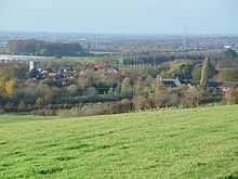
Elloughton is a village in the East Riding of Yorkshire, England. It is situated approximately 12 miles (19 km) to the west of Hull to the south of the A63 road. It lies on the southern end of the Yorkshire Wolds. It is conjoined with Brough that lies to the south-east, with which it forms the civil parish of Elloughton-cum-Brough.

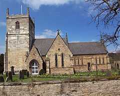
The church dedicated to St Mary was designated in 1968 by English Heritage as a Grade II* listed building.[1]
In 1823 Ellerton was in the Wapentake of Harthill, a part of the Liberty of St Peter's. The patron of the Church of St Mary was the York Minster prebendary of Wetwang. Within the village was a Methodist and a Calvinist chapel. The village had a population of 318, with occupations including six farmers, two carpenters, two tailors, a blacksmith, a shoemaker, and a bricklayer. Also directory-listed were three yeomen, a school master, a gentlewoman, and a curate. Once a week two carriers operated between the village and Hull.[2]
References
- ↑ Historic England. "Church of St Mary (1203258)". National Heritage List for England. Retrieved 17 August 2013.
- ↑ Baines, Edward (1823): History, Directory and Gazetteer of the County of York, p. 201
- Gazetteer — A–Z of Towns Villages and Hamlets. East Riding of Yorkshire Council. 2006. p. 5.
External links
 Media related to Elloughton at Wikimedia Commons
- Elloughton in the Domesday Book
| ||||||||||||||||||||||||||