Ellington, Cambridgeshire
| Ellington | |
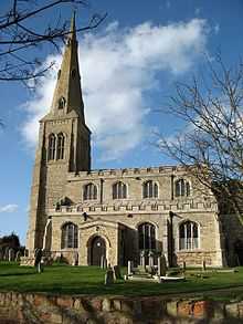 All Saints Church located in Ellington |
|
 Ellington |
|
| OS grid reference | TL158716 |
|---|---|
| District | Huntingdonshire |
| Shire county | Cambridgeshire |
| Region | East |
| Country | England |
| Sovereign state | United Kingdom |
| EU Parliament | East of England |
|
|
Coordinates: 52°20′N 0°18′W / 52.33°N 0.30°W
Ellington – in Huntingdonshire (now part of Cambridgeshire), England – is a village near Easton west of Huntingdon.
The village itself contains just over 230 houses[1] and according to the 2011 census data it has a population of 585 residents.[2] The Parish "Ellington" also includes Ellington Thorpe, a smaller settlement located just less than a mile south of Ellington itself. Ellington Thorpe is a very small hamlet containing just a few 17th-century cottages. Ellington Thorpe was previously known as 'Sibthorpe'.[3] Its total area is around 2,700 acres; however, nearly three quarters of it is grass land. Local amenities in Ellington include The Mermaid Pub, The Village hall and the All Saints Church (pictured); furthermore there are playing fields including a football pitch, tennis courts and more recently updated playground.[4]
History
In 1870, Ellington was described as,
- "A parish in the district and county of Huntingdon; on an affluent of the river Ouse, 5 miles W of Huntingdon r. station. Post town, Brampton, under Huntingdon. Acres, 2, 910. Real property, £3, 956. Pop., 413. Houses, 95. The property is much sub-divided. The living is a vicarage in the diocese of Ely. Value, £168.* Patron, St. Peter's College, Cambridge. The church is good; and there are a Baptist chapel, and charities £56."[5]
In terms of civil registration, from 1 July 1837, Ellington was a district of Huntingdonshire. Following this it became a sub-district of Spaldwick, but has now returned to being a district of Huntingdonshire.[6]
The Mermaid Inn is Ellington's local public house. The pub gets its name from the particular type of timber used for the skeleton of the building during construction; today the ancient beams are visible from the bar area and the dining room.[7]
Churches
The All Saints Church, Ellington is mentioned in the 1086 Domesday survey, although nothing earlier than the 13th Century remains; over the years the church has been changed and updated, such as the south aisle which was either altered or added around the 14th century period. Towards the end of the 14th century, it is believed that the tower was either added or rebuilt. The 16th century saw the construction of the south porch. The chancel was rebuilt in 1863, the spire restored in 1899 and the nave roof in 1907.[8] Even though the church has been partly rebuilt, the church today is in good condition. The 15th-century roofs are still present and the carved timberwork supported by the figures of angels. The bells currently inside the tower have been ringing for well over 300 years and continue to do so.[9]
Demographics
Population

Ellington’s population graph (as pictured) shows that over the period between 1851 through until 2011 the parish has held a relatively stable number of residence. The census reports show that the population, as reported in 1851 was around 450. It reached its lowest point in 1931 when the population of the parish dramatically dropped to just above 217. At this particular time, the First World War could well be the most likely reason for this fall in population. Although following the world wars, the residency of Ellington consistently rose from just over 217 to above 624 in 2001. The most recent census data from 2011 shows us that there has been the first drop in the population figures in 100 years, since 1911. The most noticeable section of the population graph is the clear rise from the year 1931 to the year 2001, where the population of Ellington grew from 217[10] right up to 624.[11] This substantial increase could well be the result of the growth of Huntingdon only 2 miles away. In 1910, the population of the town of Huntingdon was at 18,399,[12] and today, according to the 2011 census, the population of the town is at 23,732.[13] Over 100 years this is a growth of roughly 50 people per year. This shows that the growth of near by Huntingdon could well have had an influence on the increase of Ellington's population.
Occupation and Employment

The graph pictured represents the occupational statistics show that wholesale and retail is the most dominant form of employment for the residents of Ellington. Other areas of employment that also have high rates are human health and social work, public administration and defence and also areas of professional, scientific and technically skilled employment.
The earliest occupational statistics of Ellington back in 1831 show the employment fields of the residents was slightly different. The main area of employment for residents at this time was agricultural laboring, in fact, more than half of the occupancy of the parish were employed in this area. Retail and handicrafts was also another popular area of employment in 1831. Retail features strongly in the more recent census data results and is still a highly popular source of work for the residents of Ellington today [14]
Geography
Location

Ellington is located 5 and a half miles away from Huntingdon. It is just off the main A14 trunk road and mostly consists of houses. However due to its closeness to Huntingdon it is slowly growing.[15] The nearest railway station is located within Huntingdonitself. Access to London is relatively straight forward. The parish itself is only 2 miles drive along the Huntingdon to Thrapston trunk road, to the A1 leading south, directly towards the M25 and London giving easy access to other routes and the city. About a miles south of the village is Grafham Water. Grafham Water is a large reservoir with a circumference of about 10 miles. It is the eighth largest reservoir in England by volume and the third largest by area. Today the reservoir is mainly used by Grafham Water Sailing club and Grafham Water Activities Centre.
More recently, in 1932, Ellington was described as being a "Curiously shaped village"[16] from information in the Victoria County History series. The article talks about the general shape of the village and how the shape of Ellington consists of the main village as well as a stretch of land to both the west and the south. It also describes a stream, The Ellington Brook, “That flows from east to west” defining Ellingtons boundary on the west stretch of land. The stream also joins up to the Alconbury Brook East of the village which flows from the village of Spaldwick.
The first recorded manor house located in Ellington unfortunately no longer exists. The manor house itself was owned by the tenants of Ramsey Abbey.[17]
Education
In terms of schooling and education, Ellington itself does not contain any schools within the parish. However, there are a number of schools within 5 miles of the parish. These include Spaldwick Primary (4–11 years) and Hitchingbrooke School in Huntingdon (11–18 years)[18]
References
- ↑ "Ellington Online". Retrieved 21 March 2014.
- ↑ "Ellington (Parish): Key Figures for 2011 census: Key Statistics". Neighbourhood Statistics. Office for National Statistics. Retrieved 5 February 2014.
- ↑ William Page, Granville Proby & S. Inskip Ladds (1936). "British History Online". pp. 44–48. Retrieved 21 March 2014.
- ↑ "Ellington Online". Retrieved 21 March 2014.
- ↑ Wilson, John Marius (1870-72). Gazetteer of England and Wales. Edinburgh: A. Fullarton & Co. Retrieved 5 February 2014. Check date values in:
|date=(help) - ↑ Hinson, Colin. "GENUKI: Ellington". Retrieved 16 March 2014.
- ↑ "The Mermaid Inn". Retrieved 11 April 2014.
- ↑ Argall, Ian. "Genuki". Retrieved 28 March 2014.
- ↑ "Ellington Village". Retrieved 28 March 2014.
- ↑ "GB Historical GIS". ELLINGTON AP/CP through time | Population Statistics | Total Population. University Of Portsmouth. Retrieved 27 April 2014.
- ↑ "Area of Ellington (Parish)". Key Figures for 2001 Census: Key Statistics. Office For National Statistics: Neighbourhood Statistics. Retrieved 27 April 2014.
- ↑ "GB Historical GIS". Huntingdon Population Statistics: Total Population. University Of Portsmouth: A Vision Of Britain Through Time. Retrieved 27 April 2014.
- ↑ "Area of Huntingdon". Key Figures for 2011 Census: Key Statistics. Office for National Statistics: Neighbourhood Statistics. Retrieved 27 April 2014.
- ↑ A Vision of Britain Through Time. [URL: http://www.visionofbritain.org.uk/unit/10254711/cube/OCC_PAR1831 "Ellington AP/CP"]. Industry Statistics | Males aged 20 & over, in 9 occupational categories, A Vision of Britain through Time. University of Portsmouth. Retrieved 27 April 2014.
- ↑ "Huntingdonshire Info - The Village of Ellington". 2002-2012 @JevStar.com. 16/05/12. Retrieved 17 March 2014. Check date values in:
|date=(help) - ↑ Page, William; Granville Proby; S. Inskipp Ladds (136). "A History of the County of Huntingdon". Parishes: Ellington 3: 44–48. Retrieved 27 April 2014.
- ↑ Hinson, Colin. "ELLINGTON Geographical and Historical information from 1932". The Victoria County History series 1932. Genuki. Retrieved 27 April 2014.
- ↑ "Schools Finder: Ellington School search". DirectGov. Retrieved 27 April 2014.
External links
![]() Media related to Ellington, Cambridgeshire at Wikimedia Commons
Media related to Ellington, Cambridgeshire at Wikimedia Commons