Elk, Kansas
| Elk, Kansas | |
|---|---|
| Ghost Town | |
|
1893 map showing Elk on the border of Chase and Marion Counties | |
 Elk | |
| Coordinates: 38°25′0″N 96°49′0″W / 38.41667°N 96.81667°WCoordinates: 38°25′0″N 96°49′0″W / 38.41667°N 96.81667°W | |
| Country | United States |
| State | Kansas |
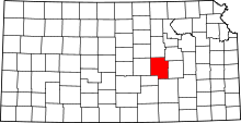
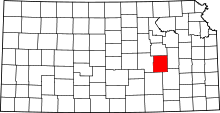
| County | Chase, Marion |
| Population | |
| • Total | 0 |
| Time zone | CST (UTC-6) |
| • Summer (DST) | CDT (UTC-5) |
| Area code | 620 |

Elk is a ghost town in Chase and Marion counties in the U.S. state of Kansas.[1] It lay along Middle Creek northwest of Elmdale and straddled the county line between Chase and Marion County.[2][3]
History
Founded in the 19th century,[4] it remained into the 1920s.[5] The community is no longer in existence.[6] The settlement had a general store, and a post office until 1923, when it was replaced by rural free delivery.[7] A post office existed in Elk from August 24, 1874 to December 15, 1924.[8]
Geography
Climate
The climate in this area is characterized by hot, humid summers and generally mild to cool winters. According to the Köppen Climate Classification system, Elk has a humid subtropical climate, abbreviated "Cfa" on climate maps.[9]
See also
- Diamond Creek Township, Chase County, Kansas, east side of Elk
Further reading
References
- ↑ DeLorme. Kansas Atlas & Gazetteer. 4th ed. Yarmouth: DeLorme, 2009, 50. ISBN 0-89933-342-7.; with this map
- ↑ Page 14 from Atlas of the World, 1914.
- ↑ Marion County Kansas : Past and Present; Sondra Van Meter; MB Publishing House; LCCN 72-92041; 344 pages; 1972.
- ↑ Shown on this 1893 map
- ↑ Shown on this 1921 map
- ↑ DeLorme. Kansas Atlas & Gazetteer. 4th ed. Yarmouth: DeLorme, 2009, 50. ISBN 0-89933-342-7.
- ↑ University of Nebraska-Lincoln Center for Great Plains Studies, Great Plains Quarterly, vol. 7-8, p. 253
- ↑ "Kansas Post Offices, 1828-1961 (archived)". Kansas Historical Society. Retrieved 5 June 2014.
- ↑ Climate Summary for Elk, Kansas
External links
- Historical
- Marion County cemetery list, archive of KsGenWeb
- Marion County history bibliography, Marion County school bibliography, Kansas Historical Society
- Maps
| |||||||||||||||||||||||||||||
| |||||||||||||||||||||||||||||