Elizabethtown, New York
| Elizabethtown, New York | |
|---|---|
| Town | |
|
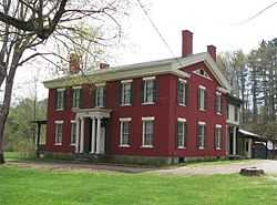
Hand House, on the National Register of Historic Places | |
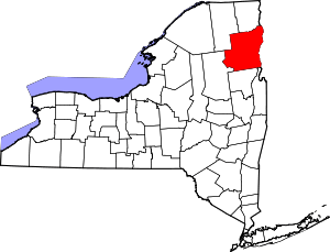
 Elizabethtown, New York Location within the state of New York | |
| Coordinates: 44°11′30″N 73°35′38″W / 44.19167°N 73.59389°WCoordinates: 44°11′30″N 73°35′38″W / 44.19167°N 73.59389°W | |
| Country | United States |
| State | New York |
| County | Essex |
| Government | |
| • Type | Town Council |
| • Town Supervisor | Margaret Bartley (D) |
| • Town Council |
Members' List
|
| Area | |
| • Total | 83.1 sq mi (215.2 km2) |
| • Land | 81.7 sq mi (211.6 km2) |
| • Water | 1.4 sq mi (3.6 km2) |
| Elevation | 607 ft (185 m) |
| Population (2010) | |
| • Total | 1,163 |
| Time zone | Eastern (EST) (UTC-5) |
| • Summer (DST) | EDT (UTC-4) |
| ZIP code | 12932 |
| Area code(s) | 518 |
| FIPS code | 36-23833 |
| GNIS feature ID | 0978930 |
Elizabethtown is a town in Essex County, New York, United States. The population was 1,163 at the 2010 census. The county seat of Essex County[1] is a hamlet also called Elizabethtown. The name is derived from Elizabeth Gilliland, the wife of an early settler.
The Town of Elizabethtown is in the east-central part of the county. It is 27 miles (43 km) southwest of Burlington, VT, 92 miles (148 km) south of Montreal, Quebec, and 106 miles (171 km) north of Albany, New York.[2] The town calls itself the "Pleasant Valley."
History

William Gilliland, an investor, bought up large tracts of land in Essex County. The town was first settled around 1792 near New Russia.
The Town of Elizabethtown was established in 1798 from the Town of Crown Point. The community of Elizabethtown in this town became the county seat, succeeding a location in the Town of Essex. Parts of the town were used to form the Towns of Moriah (1808), Keene (1898), and Westport (1815).
The lumber industry and processing iron ore were important in the beginning, but tourism became prominent by the end of the 19th Century.
Geography
According to the United States Census Bureau, the town has a total area of 83.1 square miles (215 km2), of which 81.7 square miles (212 km2) is land and 1.4 square miles (3.6 km2) (1.68%) is water.
The Black River marks the eastern town line.
Interstate 87, the Northway, is a major divided highway passing through the southeast part of Elizabethtown. U.S. Route 9 is a north-south highway. New York State Route 9N is an east-west highway, which intersects U.S. Route 9 in downtown Elizabethtown.
Demographics
As of the census[3] of 2000, there were 1,315 people, 497 households, and 318 families residing in the town. The population density was 16.1 people per square mile (6.2/km²). There were 794 housing units at an average density of 9.7 per square mile (3.8/km²). The racial makeup of the town was 97.49% White, 0.68% African American, 0.61% Asian, 0.08% Pacific Islander, 0.23% from other races, and 0.91% from two or more races. Hispanic or Latino of any race were 0.38% of the population.
There were 497 households out of which 30.8% had children under the age of 18 living with them, 51.7% were married couples living together, 8.5% had a female householder with no husband present, and 36.0% were non-families. 31.4% of all households were made up of individuals and 16.7% had someone living alone who was 65 years of age or older. The average household size was 2.32 and the average family size was 2.92.
In the town the population was spread out with 23.1% under the age of 18, 4.5% from 18 to 24, 22.1% from 25 to 44, 26.3% from 45 to 64, and 24.0% who were 65 years of age or older. The median age was 45 years. For every 100 females there were 94.0 males. For every 100 females age 18 and over, there were 87.6 males.
The median income for a household in the town was $32,244, and the median income for a family was $44,531. Males had a median income of $28,295 versus $23,594 for females. The per capita income for the town was $17,059. About 9.1% of families and 15.7% of the population were below the poverty line, including 20.8% of those under age 18 and 10.4% of those age 65 or over.
Communities and locations in Elizabethtown
- Black River – A small river that flows into Lincoln Pond.
- Bouquet River – A small stream the flows northward through the center of the town.
- Colonial Garden – A display garden in Elizabethtown on US-9 / NY-9N, behind the Essex County Historical Society | Adirondack History Center Museum. http://www.adkhistorycenter.org/
- Elizabethtown – The hamlet of Elizabethtown, the county seat is at the junction of US-9 and NY-9N. The community has been the county seat since 1807.
- Euba Mills – A location in the southwest corner of the town on US-9 at the junction of County Road 70.
- Hurricane Mountain – A notable elevation in the northwest part of Elizabethtown.
- Lincoln Pond – A lake in the southeast corner of the town.
- New Pond – A small lake at the south town line near Euba Mills.
- New Russia – A hamlet south of Elizabethtown on US-9.
- Pauline Murdock Wildlife Management Area – A conservation area northeast of Elizabethtown village.
- The Northway --- Interstate 87 traverses the southeastern part of the town.
Notable residents
- Ezra C. Gross, U.S. Representative from New York, March 4, 1819 to March 3, 1821)
- Robert S. Hale, U.S. Representative from New York, December 3, 1866 to March 3, 1867 and March 4, 1873 to March 3, 1875
- Augustus C. Hand, U.S. Representative from New York, March 4, 1839, to March 3, 1841
- Augustus Noble Hand, Judge who served on the United States District Court for the Southern District of New York
- Learned Hand, Judge of United States Court of Appeals for the Second Circuit
- Orlando Kellogg, U.S. Representative from New York, March 4, 1847 to March 3, 1849
- Thomas W. Lamb, Architect
- Gregor Piatigorsky, Cellist
- Jacqueline Piatigorsky, Chess and tennis champion, author, sculptor
- Charles Poletti, 46th Governor of New York
- Mary Post, American teacher and a pioneer of education in Arizona.
References
- ↑ "Find a County". National Association of Counties. Retrieved 2011-06-07.
- ↑ Elizabethtown, NY on Wolfram Alpha.
- ↑ "American FactFinder". United States Census Bureau. Retrieved 2008-01-31.
External links
- Elizabethtown information from the Chamber of Commerce
- Elizabethtown history
- Essex County Historical Society | Adirondack History Center Museum
- Elizabethtown on the Adirondack Northway: I-87
| |||||||||||||||||||||||||||||