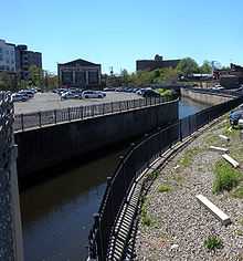
Elizabeth River (New Jersey)

The Elizabeth River is a waterway in Essex and Union Counties, New Jersey in the United States, draining into the Arthur Kill
The Elizabeth River rises in an urban area at the border between Irvington and the Vailsburg neighborhood of Newark, New Jersey.[1] It flows in a generally southern direction through the center of Irvington, passing alongside the Civic Square. Further south, it forms the west boundary of the 19th century Clinton Cemetery.[2] At the southern end of the cemetery, the river passes under the Garden State Parkway near exit 143 and disappears as a surface waterway.
The Elizabeth River reemerges just south of the Essex/Union County border near exit 142/142 A on the Garden State Parkway. From this point until the river enters the city of Elizabeth, it forms the border between Union Township and Hillside. After passing under Interstate 78, the river enters the Union County run Elizabeth River Parkway. Here, the river is joined on its left bank by its first significant tributary, Lightning Brook. The Elizabeth River then flows under the Garden State Parkway for the second and final time. After passing under U.S. Route 22, the Elizabeth River turns eastward and is joined by the West Branch Elizabeth River. The river then flows past historic Liberty Hall and Kean University, before entering the city of Elizabeth.
In the city of Elizabeth, the river crosses Westfield Avenue, W Jersey St, and Broad St as well as U.S. Route 1/9 to flow parallel to Elizabeth Avenue. It empties underneath a bridge on the S Front Street near Elizabeth Ave and S 1st St in Elizabeth, flowing into the Arthur Kill.
Work is currently underway to construct a park and riverside trail from South Broad Street in downtown Elizabeth to the river's outlet into the Arthur Kill, a distance of 2-1/2 miles.[3] In 2012, phase I of the trail opened.[3]
Recently, the City Hall of Elizabeth did start a project to re-introduce fish to the river as well as to clean it up.
See also
References
- ↑ https://www.google.com/maps/@40.736606,-74.228513,3a,75y,266.66h,72.28t/data=!3m4!1e1!3m2!1sSKwJK-6_XJMyws09CyIGvA!2e0
- ↑ https://www.google.com/maps/@40.720388,-74.237253,3a,75y,124.03h,70.76t/data=!3m4!1e1!3m2!1s1qqUHAS9JrdufmaK7jvjWA!2e0
- ↑ 3.0 3.1 http://www.groundworkelizabeth.com/river_trail.html
Coordinates: 40°42′06″N 74°14′54″W / 40.70159°N 74.248355°W