Electoral district of Napier
| Napier South Australia—House of Assembly | |
|---|---|
|
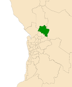
Electoral district of Napier (green) in the Greater Adelaide area | |
| State | South Australia |
| Created | 1977 |
| MP | Jon Gee |
| Party | Australian Labor Party |
| Namesake | Sir Thomas Napier |
| Electors | 23,653 (2014) |
| Area | 156.1 km2 (60.3 sq mi) |
| Demographic | Metropolitan |
| Coordinates | 34°41′47″S 138°45′7″E / 34.69639°S 138.75194°ECoordinates: 34°41′47″S 138°45′7″E / 34.69639°S 138.75194°E |
Napier is an electorate created in 1977 for the South Australian Legislative Assembly[1] in the northern suburbs of the Adelaide metropolitan area of South Australia.
Napier is named after Sir Thomas John Mellis Napier (1882–1976) who was Chief Justice of South Australia for 25 years and a total of 43 years in the Supreme Court.
Napier is located in the outer north of Adelaide, including Blakeview, Davoren Park, Elizabeth Downs, Evanston South, Kudla, Munno Para, Smithfield and Smithfield Plains, parts of Craigmore, Evanston Park and Munno Para Downs; as well as semi-rural Bibaringa, One Tree Hill, Sampson Flat, Uleybury and Yattalunga, and part of Humbug Scrub.
Members for Napier
| Member | Party | Term | |
|---|---|---|---|
| Terry Hemmings | Australian Labor Party | 1977–1993 | |
| Annette Hurley | Australian Labor Party | 1993–2002 | |
| Michael O'Brien | Australian Labor Party | 2002–2014 | |
| Jon Gee | Australian Labor Party | 2014–present | |
Election results
Main article: Electoral results for the district of Napier
| South Australian state election, 2014: Napier[2][3] | |||||
|---|---|---|---|---|---|
| Party | Candidate | Votes | % | ±% | |
| Labor | Jon Gee | 9,689 | 47.6 | −7.2 | |
| Liberal | Robert Leggatt | 6,206 | 30.5 | +4.0 | |
| Family First | Gary Balfort | 2,741 | 13.5 | +3.7 | |
| Greens | Sam Miles | 1,722 | 8.5 | +2.9 | |
| Total formal votes | 20,358 | 95.7 | −0.0 | ||
| Informal votes | 906 | 4.3 | +0.0 | ||
| Turnout | 21,264 | 89.9 | −1.4 | ||
| Two-party-preferred result | |||||
| Labor | Jon Gee | 12,024 | 59.1 | −7.1 | |
| Liberal | Robert Leggatt | 8,334 | 40.9 | +7.1 | |
| Labor hold | Swing | −7.1 | |||
Notes
- ↑ "Statistical Record of the Legislature, 1836 - 2007" (PDF). Parliament of South Australia. Retrieved 26 January 2014.
- ↑ 2014 State Election Results – Napier, ECSA.
- ↑ 2014 State Election Results – Napier, ABC.
References
| ||||||
