Electoral district of Euroa
| Euroa Victoria—Legislative Assembly | |
|---|---|
|
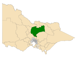
Location of Euroa (dark green) in Victoria | |
| State | Victoria |
| Created | 2014 |
| MP | Steph Ryan |
| Party | National |
| Electors | 45,847 (2014) |
| Area | 11,635 km2 (4,492.3 sq mi) |
| Demographic | Rural |
The Electoral district of Euroa is an electoral district of the Victorian Legislative Assembly in Australia. It was created in the redistribution of electoral boundaries in 2013.[1]
It is a new district created due to the abolition of the districts of Seymour and Benalla, taking in the areas to the north of these districts toward Shepparton. It includes the towns of Benalla, Violet Town, Euroa, Seymour, Heathcote, Nagambie, Rushworth, and other towns in the Campaspe, Strathbogie, Benalla, and Mitchell local government areas.[2]
Euroa is estimated to be a safe Coalition seat with a margin of 13.6%.[3]
Members
| Member | Party | Term | |
|---|---|---|---|
| Steph Ryan | National | 2014–present | |
Election results
Main article: Electoral results for the district of Euroa
| Victorian state election, 2014: Euroa | |||||
|---|---|---|---|---|---|
| Party | Candidate | Votes | % | ±% | |
| National | Steph Ryan | 14,494 | 35.3 | −4.1 | |
| Labor | Clare Malcolm | 11,428 | 27.9 | +0.8 | |
| Liberal | Tony Schneider | 10,454 | 25.5 | +12.1 | |
| Greens | Simon Roberts | 2,110 | 5.1 | −0.8 | |
| Family First | Julie-Anne Winzer | 1,307 | 3.2 | +1.4 | |
| Country Alliance | Lisa Adams | 1,238 | 3.0 | −5.1 | |
| Total formal votes | 41,031 | 95.3 | −0.0 | ||
| Informal votes | 2,016 | 4.7 | +0.0 | ||
| Turnout | 43,047 | 93.9 | +4.5 | ||
| Two-party-preferred result | |||||
| National | Steph Ryan | 26,451 | 64.5 | +0.9 | |
| Labor | Clare Malcolm | 14,580 | 35.5 | −0.9 | |
| National hold | Swing | +0.9 | |||
External links
References
- ↑ "Summary of Changes". Victorian Electoral Boundary Commission. Retrieved 17 October 2013.
- ↑ "Map of Euroa District". Victorian Electoral Boundaries Commission.
- ↑ Green, Antony. "2013 Victorian Redistribution Analysis of Electoral Boundaries". ABC.
