Eleşkirt
| Eleşkirt | |
|---|---|
|
General view of Eleşkirt | |
 Eleşkirt | |
| Coordinates: 39°47′53″N 42°40′28″E / 39.79806°N 42.67444°ECoordinates: 39°47′53″N 42°40′28″E / 39.79806°N 42.67444°E | |
| Country |
|
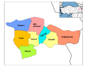
| Province | Ağrı |
| Government | |
| • Mayor | Sebahattin Sarı (AKP) |
| • Kaymakam | Mustafa Koç |
| Area[1] | |
| • District | 1,545.18 km2 (596.60 sq mi) |
| Population (2012)[2] | |
| • Urban | 11,247 |
| • District | 39,040 |
| • District density | 25/km2 (65/sq mi) |
| Website |
www |
%2C_Agir%C3%AE.jpg)
Eleşkirt or Kurdish Zêdikan, is a town and district of Ağrı Province in Turkey. Its name was transferred from Alashkert (Armenian: Ալաշկերտ Alaškert), the valley's former administrative centre, now the village of Toprakkale. Until the Armenian Genocide the town was populated by Armenians.
The mayor is Sebahattin Sarı (AKP).
Places to see
Eleşkirt is a small town on a plain surrounded by high mountains, that has been occupied since the kingdom of the Urartu, as can be seen from:
- A burial mound (höyük) in the village of Pirabat
- The castle in the village of Toprakkale (ku:Kelê). In antiquity the district was ruled from the castle which was successively occupied by Romans, Persians, Armenians, Arabs, Greek Byzantines, Seljuk Turks, Mongols and then further waves of Turks. There is a mosque which was built in 1687 in this village.
- There is a mountain named Kösedağ near the town. It is popular for climbing and, in winter, skiing. Actually a lot of tourists come to see and climb this mountain from different countries every year.
References
- ↑ "Area of regions (including lakes), km²". Regional Statistics Database. Turkish Statistical Institute. 2002. Retrieved 2013-03-05.
- ↑ "Population of province/district centers and towns/villages by districts - 2012". Address Based Population Registration System (ABPRS) Database. Turkish Statistical Institute. Retrieved 2013-02-27.