Elati, Kozani
| Elati Ελάτη | ||
|---|---|---|
| ||
 Elati | ||
|
Location within the region | ||
| Coordinates: 39°58′N 21°49′E / 39.967°N 21.817°ECoordinates: 39°58′N 21°49′E / 39.967°N 21.817°E | ||
| Country | Greece | |
| Administrative region | West Macedonia | |
| Regional unit | Kozani | |
| Municipality | Servia–Velventos | |
| Municipal unit | Kamvounia | |
| • Mayor | (since 2006) | |
| Area | ||
| • Total | 40.0 km2 (15.4 sq mi) | |
| Elevation | 650 m (2,130 ft) | |
| Population (2007) | ||
| • Total | 450 | |
| • Density | 11/km2 (29/sq mi) | |
| Time zone | EET (UTC+2) | |
| • Summer (DST) | EEST (UTC+3) | |
| Postal code | 505 00 | |
| Area code(s) | +30 24640 | |
| Vehicle registration | ΚΖ | |
| Website | www.kozanh.gr | |

Elati (Greek: Ελάτη) is a village in the Kozani regional unit, Greece. It is part of the municipal unit Kamvounia.
Gallery
-
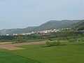
Elati seen from the west 2009
-

Metamorphosis Church in Elati 2009
-
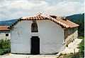
Saint Paraskevi's Church
-

Saint Nikanoras Monastery west of Elati 2009
-

Hermitage close to Elati 2009
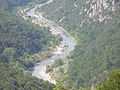
-

View over Elati into the valley 2009
-

Traditional dances
-

Educational association
-

Football club "Elatos"
-

Rogatziarika at New Year
-
Panoramic view of Aliakmon river
-

Steel bridge over Aliakmonas river west of Elati 2009
-
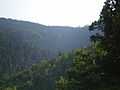
The fir-rich forest
-

Forestal landscape
References
External links
| Wikimedia Commons has media related to Elati, Kozani. |
| ||||||||||||||||||