El Pinell de Brai
| El Pinell de Brai | ||
|---|---|---|
| Municipality | ||
| ||
 El Pinell de Brai Location in Catalonia | ||
| Coordinates: 41°01′02″N 0°30′56″E / 41.01722°N 0.51556°ECoordinates: 41°01′02″N 0°30′56″E / 41.01722°N 0.51556°E | ||
| Country |
| |
| Community |
| |
| Province | Tarragona | |
| Comarca | Terra Alta | |
| Area | ||
| • Total | 57 km2 (22 sq mi) | |
| Elevation | 101 m (331 ft) | |
| Population (2007) | ||
| • Total | 1,174 | |
| • Density | 21/km2 (53/sq mi) | |
| Time zone | CET (UTC+1) | |
| • Summer (DST) | CEST (UTC+2) | |
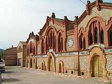
Old wine stores.
El Pinell de Brai is a municipality in the comarca of la Terra Alta in Catalonia, Spain.
This town is located in a small plain surrounded by mountains including Serra de Pàndols and Serra de Cavalls. This area suffered badly during the Battle of the Ebro in the Spanish Civil War (1936–39). There is a point called Hill 705 Cota 705 on top of the highest peak of Serra de Pàndols range near the town on which stands a monument to those who died in the battles.[1] Like in Corbera d'Ebre, some of the town's houses destroyed in the Civil War have been kept as they are and are known as "The Fallen Houses" Les Cases Caigudes.
References
External links
| Wikimedia Commons has media related to El Pinell de Brai. |
- Pàgina web de l'Ajuntament
- Informació de la Generalitat de Catalunya
- Informació de l'Institut d'Estadística de Catalunya
- Associació Cultural Pi del Broi
 |
Gandesa | Benissanet | | |
| |
Miravet | |||
| ||||
| | ||||
| Prat de Comte | Benifallet |
| ||||||||