Egnar, Colorado
| Egnar, Colorado | |
|---|---|
| Unincorporated community | |
| Coordinates: 37°55′04″N 108°56′26″W / 37.91778°N 108.94056°WCoordinates: 37°55′04″N 108°56′26″W / 37.91778°N 108.94056°W | |
| Country |
|
| State |
|
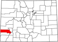
| Counties | San Miguel[1] |
| Elevation[1] | 7,329 ft (2,234 m) |
| Time zone | MST (UTC-7) |
| • Summer (DST) | MDT (UTC-6) |
| ZIP code[2] | 81325 |
| Area code(s) | 970 |
Egnar is an unincorporated community, whose name is "Range" spelled backward, also referred to locally as "little Missouri." Egnar has a U.S. Post Office in San Miguel County, Colorado, United States. The Egnar Post Office has the ZIP Code 81325.[2]
Geography
Egnar is located at 37°55′04″N 108°56′26″W / 37.91778°N 108.94056°W (37.917660,-108.940430).
References
- ↑ 1.0 1.1 "US Board on Geographic Names". United States Geological Survey. 2007-10-25. Retrieved 2008-01-31.
- ↑ 2.0 2.1 "ZIP Code Lookup" (JavaScript/HTML). United States Postal Service. December 15, 2006. Retrieved December 15, 2006.
| |||||||||||||||||