Eglwyscummin
| Eglwyscummin | |
| Welsh: Eglwys Gymyn | |
 Eglwyscummin |
|
| Population | 432 (2011)[1] |
|---|---|
| OS grid reference | SN230106 |
| Community | Eglwyscummin |
| Principal area | Carmarthenshire |
| Ceremonial county | Dyfed |
| Country | Wales |
| Sovereign state | United Kingdom |
| Post town | Whitland |
| Postcode district | SA34 |
| Dialling code | 01834 |
| 01994 | |
| Police | Dyfed-Powys |
| Fire | Mid and West Wales |
| Ambulance | Welsh |
| EU Parliament | Wales |
| UK Parliament | Carmarthen West and South Pembrokeshire |
| Welsh Assembly | Carmarthen West and South Pembrokeshire |
|
|
Coordinates: 51°45′58″N 4°33′58″W / 51.766°N 4.566°W
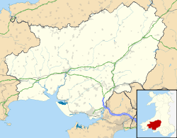
Eglwyscummin (Welsh: Eglwys Gymyn) is a Community Ward situated on the south-western boundary of Carmarthenshire in south-west Wales. It is made up of the three ward parishes of Ciffig, Eglwyscummin, and Marros, all surrounding the village of Red Roses, which lies some three miles south of Whitland.
The area consists mostly of farmland and is traversed from east to west by the main A477 road leading to south Pembrokeshire and the Pembroke Dock ferry port, crossed at Red Roses by the B4314 running southeastwards from the county boundary at Tavernspite to the once popular seaside resort of Pendine Sands.
Administration
Carmarthenshire County Council administers the area with Eglwyscummin Community Council providing some local direction. Eglwyscummin Community Association has, on occasion, been responsible for providing a more open forum for general members of the Community. So too had The Taf Myrddin Community Network which provided a direct interface between the County Council Executive and the general public. Although successful, the Network was ended by the County Council in early 2009.
Places
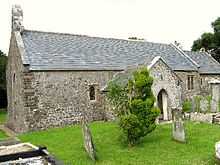
Places of worship incluude Ciffig (also Cyffig) parish church, St. Margaret's grade I listed parish church and hall in Eglwyscummin and St. Lawrence's parish church in Marros.
Eglwyscummin Community Centre is situated in Red Roses with a Memorial Garden adjacent which was built by members of the local Young Farmers Group.
Apart from the local farms, other businesses in the area include a horse riding school, a shooting range, several caravan parks, holiday cottages for the disabled, a bus company, a farm producing ice cream and cheese, an Autograss league track and the Green Bridge Inn public house situated between Marros and Pendine.
The community lies on the northern shore of Carmarthen Bay. It is bordered by the communities of Amroth and Lampeter Velfrey in Pembrokeshire; and by: Whitland; Llanboidy; St Clears; Llanddowror; and Pendine, all being in Carmarthenshire.
History
The English translation from the Welsh name Eglwyscummin is "church community" although the name derived from the Celtic Saint Cynin. There were five churches within the district but currently now only three remain in use with St Cyffig's Church now taking services again after maintenance work was carried out during 2006/7. The Gothic Revival architect C.C. Rolfe restored St. Margaret's parish church in 1878.[2] Some history of the area can be found here: . Eglwyscummin is the only known place where an Ogham inscription commemorates a woman: Avitoriges, daughter of Cunigni.
Development
Plans for a by-pass route to take over from the current poorly rated, accident-ridden route from St. Clears to Red Roses on the A477 had been announced by the Welsh Assembly to take place from 2010 but was delayed.[3] Work eventually took place between 2012 and 2014.[4]
Sources
- Lloyd, Thomas (2006). The Buildings of Wales: Carmarthernshire and Ceredigion. ISBN 0-300-10179-1.
- Saint, Andrew (1970). "Three Oxford Architects". Oxonensia (Oxfordshire Architectural and Historical Society) XXXV: 53 ff. Retrieved 3 November 2009.