Egå Engsø
| Egå Engsø | |
|---|---|
 View of the eastern end of Egå Engsø, from the bird tower. | |
| Location | Midtjylland region |
| Coordinates | 56°13′05″N 10°13′16″E / 56.218°N 10.221°ECoordinates: 56°13′05″N 10°13′16″E / 56.218°N 10.221°E |
| Type | tunnel valley |
| Primary inflows | Egå, Ellebækken |
| Primary outflows | Egå |
| Catchment area | km² |
| Basin countries | Denmark |
| Surface area | 1.15 km² |
| Average depth | 1 m |
| Max. depth | 1.7 m |
| Shore length1 | 5.2 km |
| Settlements | Aarhus |
| 1 Shore length is not a well-defined measure. | |
Egå Engsø is an artificial lake and wetland site located in the north of the town of Aarhus between Vejlby, Risskov and Lystrup. Engsø means 'meadow lake' and Egå means 'Oak stream', referring to the stream that drains the lake into the Aarhus bay. The lake area is bordered by the Djursland motorway to the north and the Aarhus-Grenaa railway and the municipal heating pipes from Studstrup Power Station to the south and east.
Background
Egå Engsø was created by re-flooding meadows on land previously drained in the 1950s for agricultural use. By the 1990s the water quality and natural ecosystem in and around the Egå river into which the site drained had declined due to the effect of nitrate fertilizer (eutrophication) use, through intensive farming in the area. Aarhus Municipality, Aarhus County and the Danish Forest and Nature Agency resolved to construct the lake as part of Vandmiljøplan II (English: Action Plan for the Aquatic Environment II) from 1998 to reduce this effect through bacterial denitrification .[1] Another major reason for initiating the project, have been the need for a strengthened defence against increasing rainfalls. The lake was created alongside work on the new Djursland motorway, and completed in 2006. Aarhus municipality is single owner. [2] [3]
Surroundings
The lake covers approximately 115 hectares (280 acres), with another ~50 hectares (120 acres) hectares of meadow and paths. It is not possible to reach the lake edge in most places, as the lake brinks are reserved grazing cattle. The grazing helps to restrict the growth of shrubs and woody plants and maintain a natural meadow habitat. It also increases the biodiversity. The amount of water in the lake, varies a great deal (by design) with weather and season, but under normal conditions, the average depth is about 1 m. Water levels can rise by an additional meter or more. The lake contains a number of fish species, fishing is prohibited however, as is swimming.
On the south brink, there is a bird hide erected in 2007, whose construction was funded by Australian wine firm Banrock Station. The lake attracts many different bird species in high numbers, with 169 species registered up to 2010.
A path c. 5 km long (with each km marked) runs round the outside of the lake, suitable for walking, running or biking. There are 2 parking lots, near the motorway junction from Lystrupvej at the north east corner and from Viengevej in the south east corner. There is also access by bike or on foot from Terp and from Vejby passing underneath the railway line on the eastern side. On the southern edge lies an activity and learning area for children and schools, modelled on a Stone Age settlement, and a number of shelters which may be booked for camping. It is a popular area and it is a statutory goal of the Aarhus municipality to make it publicly accessible and attractive for the citizens.[4]
Special flora and fauna
Many specimens of the flora and fauna at Egå Engsø, are either rare or relatively rare in Denmark. Some are on the Danish Red List (under IUCN Red List) and/or protected under different habitat directives of the European Union. Here is a few examples:[5]
- Common comfrey (Danish: Læge-Kulsukker) is growing here, but is rare in Denmark. It is slightly poisonous and carcinogenic, but have nevertheless been used extensively in folklore-medicine as a wound healing plant among other uses.[6][7]
- The globally endangered (EN) Thick shelled river mussel has established here. It is rare in Denmark and is to be protected under the EU habitat directive (II and IV). It is an indicator species of good water quality and important for nature management in general.
- Short-eared Owls are living and foraging here. It is endangered (EN) and relatively rare in Denmark.
- The lake area houses resting White storks, a critically endangered (CR) and relatively rare bird in Denmark.
- Eurasian Spoonbills are resting here and they are vulnerable (VU) and relatively rare in Denmark.
- The Ferruginous Ducks living here, are rare in Denmark and near threatened (NT) on a global scale.
- Black Terns are here and they are endangered (EN) and relatively rare in Denmark.
Parts of the meadows surrounding Egå Engsø, are grazed by cattle in the warmer months of the year, to create ideal conditions for the emerging flora and fauna associated with wet meadows.
Archaeological finds
In the stone age, the Egå Engsø area was a small part of a much larger fjord, that filled the entire Egå valley and stretched from the Bay of Aarhus to Lisbjerg. Moesgård Museum in Aarhus have found numerous traces from the earliest human inhabitant's settlements, boats and kitchen middens in and around the Egå valley. In the extensive primeval woods of those days, the stone age people hunted for aurochs, elk and wild boars and in the fjord they engaged in fishing, collecting shellfish and whaling even. Orcas was an important part of the meals of the stone age people at the Bay of Aarhus. The whales where killed with throwing spears and lances and the hunt was carried out from their long narrow dugout canoes, according to some sources. Bone remains from at least 16 individuals of the heavy orcas, have been accounted for at the site. Some of the excavated dugouts from the early 1990s to 2001 at 'Lystrup Enge', have been carbon-14 dated to the years 5210-4910 BC and is thus the oldest known boats in Northern Europe at present. [2] [3] [8]
Gallery
-

The stream of Egå enters the lake.
-

Egå Engsø with Lisbjerg on the hill behind. Viewed from the south.
-

Egå Engsø with Skejby on the hill in the background. Viewed from the north.
-
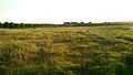
Meadows at Egå Engsø.
-
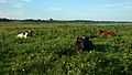
The wet meadows are grazed by cattle.
-

Activity- and learning-area at Egå Engsø.
-

Sunset at the lake.
References
- ↑ "Implementation of the Nitrates directive in Denmark". Danish Ministry of the Environment.
- ↑ 2.0 2.1 "Egå Engsø - a water treatment plant with a recreational profile". Author Kjeld Hansen.
- ↑ 3.0 3.1 Wetlands reduce flood risks in Aarhus Task Force on Climate Change Adaptation
- ↑ Accessibility to urban-close nature Aarhus municipality
- ↑ "List of Species". Fugle&Natur (Naturbasen ApS and Natural History Museum Aarhus).
- ↑ "Danish Drug list". Danish Technical University (DTU).
- ↑ "Comfrey". Botanical.
- ↑ Excavation 12 - New Lystrup road The Archaeology beneath the Expressway (Moesgård Museum) (Danish)
External links
| Wikimedia Commons has media related to Egå Engsø. |
- Egå Engsø Pamphlet Aarhus Municipality