Ecatepec de Morelos
| Ecatepec | ||
|---|---|---|
| City | ||
| San Cristóbal Ecatepec de Morelos | ||
 | ||
| ||
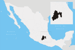
 Location in State of Mexico | ||
| Coordinates: 19°36′35″N 99°03′36″W / 19.60972°N 99.06000°W | ||
| Country |
| |
| State | State of Mexico | |
| Municipal Status | 1861 | |
| Government | ||
| • Municipal President | Pablo Bedolla | |
| Population (2010 Census (provisional)) | ||
| • Municipality and City |
1,658,806 (city) 1,688,258 (municipio) | |
| Time zone | CST (UTC−6) | |
| • Summer (DST) | CDT (UTC−5) | |
| Postal code (of seat) | 55000 | |
| Website | Official website (Spanish) | |
Ecatepec, (Spanish ![]() [ekatepe'k] once officially San Cristóbal Ecatepec de Morelos, is a city and municipality in the State of Mexico. Both are usually known simply as "Ecatepec". The city is practically co-extensive with the municipality, with the city's 2005 population of 1,687,549 being 99.9% of the total municipal population of 1,688,258.[1] The provisional population at the 2010 Census was 1,658,806. The city forms the most populous suburb of Mexico City (Ciudad de México) and the 15th-most-populous suburb in the world.
[ekatepe'k] once officially San Cristóbal Ecatepec de Morelos, is a city and municipality in the State of Mexico. Both are usually known simply as "Ecatepec". The city is practically co-extensive with the municipality, with the city's 2005 population of 1,687,549 being 99.9% of the total municipal population of 1,688,258.[1] The provisional population at the 2010 Census was 1,658,806. The city forms the most populous suburb of Mexico City (Ciudad de México) and the 15th-most-populous suburb in the world.
The name "Ecatepec" is derived from Nahuatl, and means "windy hill" or "hill devoted to Ehecatl". It was also an alternative name or invocation to Quetzalcoatl.[2] "Morelos" is the last name of José María Morelos, a hero of the Mexican War of Independence.
The municipality borders with Tecámac, Nezahualcóyotl, Acolman, San Salvador Atenco, Tlalnepantla and Distrito Federal. The area of this municipality is 155 km² (59.85 sq mi).[3]
Most inhabitants commute to Mexico City for work, and recently the Mexico City metro subway system was extended into Ecatepec.
"San Cristóbal" (Saint Christopher) is the city's patron saint, whose feast day is celebrated on July 25 of each year.[2]
Points of interest include the newest Catholic Cathedral in Mexico, Sagrado Corazón de Jesús, several colonial era churches and the colonel edifice Casa de los virreyes.[2]
History


Remains of earliest human inhabitation of the area have been found on the nearby Cerro (Hill) de Ecatepec. The area was initially settled by successive waves of Otomis; however, because of the later arrival of Toltec-Chichimecas that dominated the rest of the Valley of Mexico, this area eventually assimilated to the rest of the Valley, ending with its domination by the Aztec empire.[3] Ecatepec was an Aztec altepetl or city-state in the Valley of Mexico. From 1428 to 1539, Ecatepec was ruled by a tlatoani (literally "speaker"). The tlatoque (plural of tlatoani) of Ecatepec were closely related to the ruling dynasty of Tenochtitlan.[4] - Chimalpilli I, grandson of Moctezuma I. - Tezozomoc, son of Chimalpopoca. - Matlaccohuatl, whose daughter Teotlalco married Moctezuma II. - Chimalpilli II, son of Ahuitzotl. - Diego de Alvarado Huanitzin, grandson of Axayacatl.
Diego Huanitzin was subsequently made tlatoani of Tenochtitlan by Antonio de Mendoza, viceroy of New Spain.
During the Aztec empire, the Mexicas used the town to control trade routes going north.[2]
Ecatepec was considered an "República de Indios" (Indian Republic) 1560, allowing the village to maintain a certain amount of autonomy and keeping the succession of tlatoanis or chiefs. However, in the first part of the 17th century, this was changed to a mayorship, with the Spanish administrating, along with the communities of Zumpango and Xalostoc.[3]
The municipality was officially created on October 13, 1874.[2] On October 1, 1877, San Cristóbal Ecatepec was declared a village and "de Morelos" was added to its name.[3]
The national hero José María Morelos y Pavón was executed in Ecatepec in 1815 by the Spanish during the Mexican War of Independence. The house in which he was executed is now the Museo Casa de Morelos (Museum House of Morelos). Ecatepec was declared a city on December 1, 1980.[2]
In April 1995, the remains of a mammoth were found in Colonia Ejidos de San Cristóbal, where the ancient lakes of Xaltocan-Ecatepec and Texcoco came together and where the Aztecs build a dam to keep the fresh and salty waters separate. The bones have been tentatively dated to around 10,500 years B.C.[3]
Ecatepec de Morelos had a 2010 census population of 1,656,107 inhabitants, which makes it the most populous municipality in the nation , as well as in the state.
Subdivisions
Almost all of the population (99.934%) lives in its one urban locality, Ecatepec de Morelos, the most populous locality (city) in Mexico except for the Iztapalapa Borough of Mexico City. There are also six rural localities (cities, towns, and villages) in the municipality, half of which reported no population in the 2010 census:[5]
| Name | 2010 Census Population |
|---|---|
| Ecatepec de Morelos (city) | 1,655,015 |
| Mesa de los Leones | 578 |
| Tierra Blanca Segunda Sección (Ejido Ecatepec) | 480 |
| Vista Hermosa | 34 |
| Banco de Tepetate (La Tepetatera) | 0 |
| Caseta Trece Curva del Diablo | 0 |
| El Tejocote | 0 |
| Total Municipality | 1,656,107 |
Economy
Jumex has its headquarters in the city.[6][7]
Plaza Las Américas shopping mall is located in Ecatepec, in which are located Liverpool, Sears and Suburbia department stores as well as a WalMart.
Transportation
Ecatepec is served by Line B of the Mexico City Metro system, including stations Muzquiz, Ecatepec (a.k.a. Tecnológico), Olímpica, Plaza Aragón, and Ciudad Azteca[8][9]
Ecatepec is located on Mexican Federal Highway 85, the Mexico City-Pachuca highway, Mexican Federal Highway 57/57D (Circuito Exterior Mexiquense), and Mexican Federal Highway 132 (Ecatepec-Teotihuacán highway).
Sister cities
| City | State | Country |
|---|---|---|
| Cuautla | | |
| Guadalupe | | |
| Caracas | Miranda | |
| Namyangju | |
See also
References
- ↑ "http://www.inegi.gob.mx/est/contenidos/espanol/sistemas/conteo2005/localidad/iter/default.asp?s=est&c=10395". Retrieved 2008-03-08.
- ↑ 2.0 2.1 2.2 2.3 2.4 2.5 "Historia de Ecatepec". Retrieved 2008-03-08.
- ↑ 3.0 3.1 3.2 3.3 3.4 "Enciclopedia de los Municipios de México Estado de Mexico Ecatepec". Archived from the original on 2007-09-30. Retrieved 2008-03-08.
- ↑ Explorations in ethnohistory: Indians of central Mexico in the sixteenth century by H. R. Harvey, Hanns J. Prem
- ↑ 2010 census tables: INEGI
- ↑ "Contacto" (Archive). Jumex. Retrieved on May 27, 2014. "Antigua Carretera Mexico Pachuca, Km 12.5 Xalostoc Estado De Mexico, CP 55340"
- ↑ "Aviso de privacidad" (Archive). Jumex. Retrieved on May 27, 2014. "[...]GRUPO JUMEX, S.A. de C.V., con domicilio en Carretera México-Pachuca KM 12.5, Colonia Rústica Xalostoc, Ecatepec de Morelos, Estado de México, C.P. 55340, México"
- ↑ "Ecatepec" (in Spanish). Retrieved 6 August 2011.
- ↑ Archambault, Richard. "Ecatepec » Mexico City Metro System". Retrieved 6 August 2011.
- ↑ http://www.guadalupe-zacatecas.gob.mx/index.php/component/k2/item/76
- ↑ http://www.multilingualarchive.com/ma/enwiki/es/Caracas#Sister_cities
- ↑ http://www.oem.com.mx/esto/notas/n847140.htm
External links
| Wikimedia Commons has media related to Ecatepec de Morelos. |
- (Spanish) Portal of Ecatepec de Morelos
- (Spanish) Ayuntamiento Constitucional de Ecatepec de Morelos Official website
Coordinates: 19°36′35″N 99°03′36″W / 19.60972°N 99.06000°W