Eastern Continental Trail
| Eastern Continental Trail | |
|---|---|
|
Route of the Eastern Continental Trail through the eastern United States and Canada | |
| Length | 5400 mi (8690 km) |
| Location | Eastern United States and Canada |
| Trailheads |
Key West, Florida Belle Isle (Newfoundland and Labrador) |
| Use | Hiking |
| Elevation | |
| Elevation change | 6,643 ft (2,025 m) |
| Highest point | Clingmans Dome |
| Lowest point | Key West |
| Hiking details | |
| Trail difficulty | Moderate to Strenuous |
| Season | Summer in northern sections, year round in southernmost sections |
| Sights |
Appalachian Mountains Everglades Florida Keys Gaspé Peninsula Hudson Valley Lake Okeechobee Mount Katahdin Springer Mountain |
| Hazards |
Alligators American Black Bear Fire Ants Limited Water Tick-borne diseases Poison Ivy Severe Weather Steep Grades Venomous Snakes |
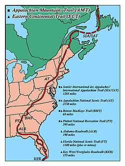
The Eastern Continental Trail (ECT) is a combination of North American long-distance hiking trails, which connect (roughly) from Key West, Florida to Belle Isle (Newfoundland and Labrador) a distance of 5,400 miles (8,700 km). A thru-hike on this system of trails requires almost a year to complete. The first person to hike the ECT from Key West to Cap Gaspe was John Brinda from Washington State, in 1997.[1]
From south to north, the route strings together the Florida Keys Overseas Heritage Trail and the Florida Trail with a walk along roads through southern Alabama, the Pinhoti National Recreation Trail and Benton MacKaye Trail in Georgia, to reach the southern terminus of the Appalachian Trail at Springer Mountain. The Appalachian Trail is connected to the International Appalachian Trail up to reach Cap Gaspé, Quebec, and more recently, Belle Isle (Newfoundland and Labrador).
The trail system was named by long distance hiker, M. J. Eberhart (trailname: Nimblewill Nomad).[2]
Trails
Trails listed in order from north to south.
- International Appalachian Trail
- Appalachian Trail
- Benton MacKaye Trail
- Pinhoti Trail
- Alabama roadwalk
- Florida Trail
- Florida Keys Overseas Heritage Trail (not finished as of 2012)
References
- ↑ "Resume: John C. Brinda". John C. Brinda. Retrieved 2011-05-25.
- ↑ "Eastern Continental Trail Guide". M. J. Eberhart. Retrieved 2009-12-20.
| ||||||||
| ||||||||
| ||||||||
| ||||||||
| ||||||||
| ||||||||||||||||||||||||||||||||||||