Eastern Anatolia Region
| Eastern Anatolia Region Doğu Anadolu Bölgesi | |
|---|---|
| Region of Turkey | |
|
| |
| Country | Turkey |
| Area | |
| • Total | 165,436 km2 (63,875 sq mi) |
The Eastern Anatolia Region (Turkish: Doğu Anadolu Bölgesi) is a geographical region of Turkey.
The region and the name "Doğu Anadolu Bölgesi" were first defined at the First Geography Congress in 1941. It has the highest average altitude, largest geographical area, and lowest population density of all regions of Turkey. Prior to getting its current name by the Turkish state, most of the region was part of the Six Armenian provinces in the region known as the Armenian Highlands.[1][2] The northeastern segment of the high plateau of Eastern Anatolia converges with the Lesser Caucasus mountain range in the region of Kars and Ardahan. From 1878 until 1917 these provinces were incorporated into the Russian Empire region of Transcaucasia as the militarily administered march province of Kars Oblast.
Subdivision
- Upper Euphrates Section (Turkish: Yukarı Fırat Bölümü)
- Erzurum - Kars Section (Turkish: Erzurum - Kars Bölümü)
- Upper Murat - Van Section (Turkish: Yukarı Murat - Van Bölümü)
- Hakkari Section (Turkish: Hakkari Bölümü)
Provinces
Provinces that are entirely in the Eastern Anatolia Region:
Provinces that are mostly in the Eastern Anatolia Region:
Location and borders
The Eastern Anatolia Region is located in the easternmost part of Turkey. It is bounded by Turkey's Central Anatolia Region to the west; Turkey's Black Sea Region to the north; Turkey's Southeast Anatolia Region and Iraq to the south; and Iran, Azerbaijan, Armenia and Georgia to the east, where Eastern Anatolia overlaps and converges with the South Caucasus region and Lesser Caucasus mountain plateau.
The area of the region is 146,330 km², which comprises 18.7% of the total area of Turkey.
Population
The total population of the region is 6,100,000 (2000 census) and 5,906,565 (2014 estimate). The region has the second most rural population of Turkey after the Black Sea region. The migration level (to the other regions, especially to Marmara Region) is high and population density (40 person/km²) is lower than the average for Turkey (98 person/km²). The migration toward other Turkey's regions and toward foreign countries is higher than the natural population increase, a fact which is leading to a slight decline of the Region's population.
Geography
The average altitude is 2,200 m. Major geographic features include plains, plateaus and massifs. There is some volcanic activity today.
Massifs and mountains
- There are three massif lines running north-south:
- To the north, the Çimen Dağı, Kop Dağı and Yalnızçam mountains
- In the centre, the Munzur, Karasu Dağı, Aras Dağı mountains
- To the south, Southeast Tauros, Bitlis, Hakkâri, and Buzul mountains.
- The volcanic mountains Nemrut, Süphan, Tendürek and Ararat are in the region.
Plateaus and plains
- The largest plateau in the region is Erzurum-Kars Plato.
- The region includes the Malatya, Elazığ, Bingöl, Muş plains and the Van Lake basin.
Lakes
Rivers
- Fırat
- Dicle
- Aras
- Kura
- Zap
Climate and nature
| Erzurum | ||||||||||||||||||||||||||||||||||||||||||||||||||||||||||||
|---|---|---|---|---|---|---|---|---|---|---|---|---|---|---|---|---|---|---|---|---|---|---|---|---|---|---|---|---|---|---|---|---|---|---|---|---|---|---|---|---|---|---|---|---|---|---|---|---|---|---|---|---|---|---|---|---|---|---|---|---|
| Climate chart (explanation) | ||||||||||||||||||||||||||||||||||||||||||||||||||||||||||||
| ||||||||||||||||||||||||||||||||||||||||||||||||||||||||||||
| ||||||||||||||||||||||||||||||||||||||||||||||||||||||||||||
Since most of the region is far from the sea, and has high altitude, it has a harsh continental climate with long winters and short summers. During the winter, it is very cold and snowy, during summer the weather is cool in the highlands and warm in the lowlands. The region has the lowest average temperature of all Turkish regions, with -25°C. Although it can get below -40°C. The summer average is about 20°C.
The region's annual temperature difference is the highest in Turkey.
Some areas in the region have different microclimates. As an example Iğdır (near Mount Ararat) has a milder climate.
The region contains 11% percent of the total forested area of Turkey. Oak and yellow pine trees form the majority of the forests. It is rich in native plants and animals.
The region has high potential for hydroelectric power.
Gallery
-
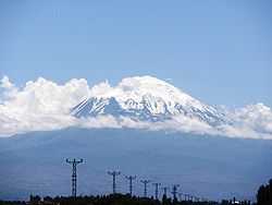
View of Mount Ağrı from Iğdır
-
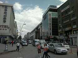
Cumhuriyet Avenue, Erzurum.
-

Çifte Minareli Medrese is an architectural monument of the late Seljuk period in the city of Erzurum
-

Monument of the Nene Hatun in the city of Erzurum
-
.JPG)
Panoramic view of the city of Bingöl
-

Panoramic view of the city of Kars
-

Akdamar Island and the Armenian Cathedral of the Holy Cross, a 10th-century Armenian church and monastic complex
-

Kars city centre
Endnotes
- ↑ Lynch, H.F.B., "Armenia, Travels and Studies" London, 1901, vol2 p391. "The natural boundary between Armenia and Asia Minor is the course of the Western Euphrates between the town of Kemah, and its passage through Taurus below Keban-Maden."
- ↑ Oswald, Felix "A Treatise on the Geology of Armenia", London, 1906.
- ↑