East Weares Rifle Range

East Weares Rifle Range is a disused rifle range on the Isle of Portland, Dorset, England. The range is situated within the area of East Weares, the east side of Portland, and sat below HM Prison Portland. It remains close to Portland Harbour, and is also known as the Naval Rifle Range.[1]
The majority of the site remains in good condition. The main part of the site features the monumental stone stop butt. The sloping back stop is infilled with earth and stone. This was the receiving end, where shots were fired into the bank. The rifle range remains on the private property of Portland Port Ltd, and has not been opened to the public. However it can be seen from surrounding coastal paths.
History

The north-eastern section of Portland, surrounding Portland Harbour has historically been a strategically important site. During the mid-19th century an arms race developed between Britain and France, following increasing political and military concern over French foreign policy. In 1845 the Royal Navy established a base at Portland, where the fleet of steam-driven warships could be replenished with coal. In 1859, with growing concerns over a French invasion, the Prime Minister Lord Palmerston launched the establishment of the Royal Commission on the Defence of the United Kingdom to recommend vital points along the south coast. This survey recommended that the Royal Dockyards at Portsmouth, Chatham, Plymouth and Portland, be fortified. As a consequence various defences at Portland Harbour were developed, including the Verne Citadel (1857-81) and East Weare Battery (1862-9). In circa 1880 the East Weare Camp was established, which included the erection of detention barracks.[2]
Prompted by the uncertain relationship with Napoleon III's France during the 1850s, the period 1860-1914 witnessed the strengthening and the creation of the most powerful complex of permanent fortifications seen in Britain and they precipitated major reforms in the army with increased attention to training. As a result another recommendation of the Royal Commission was that a musketry course should be included as part of the annual training syllabus for militia units. As a result rifle ranges established in the late 1850s as training for rifle volunteer units became a common feature of militia units from the early 1860s onwards and were provided at the majority of major barracks. Today rifle ranges built in the mid 19th-century for the purposes of training in anticipation of a war with France are rare.[3]
The East Weares Rifle Range was built between 1889 and 1903, on additional land the war department had to purchase. This was despite already having taken control of a quarter of the island.[4] Constructed using huge ramps of earth and stone, the range's large stop butt structure had been built by the 1920s, out of Portland Stone. The range was built as part of a general development of the site and its training provision, where it was used to train naval and other military service personnel, often stationed at East Weare Camp. It had not been built in response to the threat from France, as tensions had ceased by the 1880s.[5] The right of public access to the shore was left intact, however the range's presence gave fear to fishermen over the danger of stray bullets.
The rifle range was built in close proximity to Portland's railway line. During the 1860s the Portland Branch Railway was established to link Weymouth to the island. In 1866 the suggestion was made to link Easton village to the line, by travelling along the eastern side of the island towards Church Ope Cove. The construction of the line began in 1888, a year before the rifle range, and took ten years due to the unstable nature of the land. The line opened in 1900. Due to the closeness between the range and the line, red flags would be hoisted during firing sessions, meaning all railway employees were prohibited from entering the area. It was compulsory for any passing engine drivers to observe the flag poles, in the event the flags were hoisted. In addition to this, a working timetable was supplied to the range's gunner-in-charge, and he would also be notified of any special trains.[6]
In February 1903 an Admiralty Order (Council No. 11) was published based on the allowance of officers who were in charge of any Naval Rifle Range stores, including Portland's range. Chief Gunner's would receive 1s per day, gunners with under 5 years' service received 6d per day, gunners with over 5 years' service 8d per day, and those with over 10 years' service received 10d per day.[7]
The range ceased operational activity during the 1980s. During this period a woman walking her dog was killed by a stray round from a military range in use by the army near Aldershot, in Hampshire. In effort to avoid a similar accident occurring again the government decided to review all active firing ranges in the UK, and the East Weares Rifle Range was classed as dangerous, due to the uncontrolled public footpaths surrounding it. Once the range closed it was used for shotgun and clay pigeon shooting for a limited time, before falling into total disuse.
Today the rifle range stands as a reminder of the military presence at Portland. The East Weares area, including the site of the range, has been labelled a Site of Special Scientific Interest (SSSI), largely due to the scrub and wildlife being of high nature conservation value. It was decided in 2007 to release ten British Primitive goats into the area to control the scrub, and these are still kept in the area today - often seen within the range's area, sometimes sitting on the stop butt.[8]
Design
The range is orientated on a north-west to south-east axis, with firing points on earth and stone mounds at 100 yard intervals from 200 yards to 600 yards, with an additional lane of fire to the north-east, firing from 800 yards. However since the 1980s the mounds have either been severely damaged or destroyed with only the 200 yard mound surviving in reasonable condition. The soldiers would fire at the stop butt from these positions. When a firing session was completed, the personnel within the gallery would use a stick to point at where the bullets had hit the target, and the shooter would check these from his position via binoculars. The shooter's aim would be adjusted if it was necessary. The ammunition for use on the range would have been stored on the site itself, in bunkers and lockers, although weapons were held in a different location.[9]
On the opposite of the butt is the markers' gallery, at the south-east section of the site, which survives in a reasonable condition. It was the location of the machinery operating the raising and lowering of the targets, and this was achieved with the use of cables and pulleys using a Hythe pattern target frame. The target frame remaining today is made of tubular steel, and this suggests that it is a later, possibly mid-20th century replacement of the original. The gallery has a rear wall built of brick, and a timber side panel. It retains a rifle rack and a set of spaced wooden seats, added for the personnel tasked with handling the targets. The concrete canopy supported on iron stanchions is a later adaptation.[10]
At the south-east end of the range, opposite the gallery, is the large late 19th-century/early 20th century stop butt. This measures approximately 100 metres in length and 30 metres wide. The north-west face is infilled with earth and stone and was designed to absorb the bullets and prevent ricochets. The sloping south-east face and north-east side is built of unmortared Portland stone with stone buttresses.
Within the perimeter of the rifle range are two remaining concrete sentry posts, possibly of mid 20th-century origin, where lookouts would warn away walkers when shooting was taking place. One is located almost adjacent to the range site, and has steps leading from the public coast path, whilst the other is located further south, and is again reachable via the coastal path. The posts remain in good, complete condition, although the southernmost one has been targeted for a considerably larger amount of graffiti than the other. Both posts also have remaining, disused telephone posts which serviced the firing range, although one of two telephone posts at the southern-most sentry post has collapsed.[9] Another remaining, standing telephone post sits between the range and the southern-most sentry post. In addition to the two posts is a tin-corrugated observation post above the range, situated on the clifftop. Likely to date around the 1960s, the post's role was to prevent walkers from entering the range's vicinity during exercises. The post remains intact, stripped out, and externally overgrown by foliage.
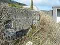
There are two World War II pillboxes within the range's perimeter. They were constructed in 1940-41, of reinforced concrete and stone, while both have a six sided plan. As with many of Portland's pillboxes and heavy anti-aircraft batteries, these structures would probably have been built by local quarrymen. Both structures are still in good condition, although overgrown. One sits next to the adjacent sentry lookout, whilst the other is located on a banking against the stop butt structure. These were constructed as a part of British anti-invasion preparations, and various other examples are located on Portland.[11][12]
Other Portland ranges
The East Weares Rifle Range was not the only active range on the island, and two other ranges were located nearby. To the north-east, a smaller range was once located along the coastline further north beyond King's Pier. It was a 300 yards rifle and revolver range of the late 19th century which was demolished in the late 20th century.[13] The range's foundations were partly constructed using the remains of the nearby King's Pier.[5]
To the immediate west was a 20th-century small arms rifle range; particularly for the 25 metre rifle, as well as handguns.[14] It was used extensively for musketry training, however around the same time as the East Weares Rifle Range, it too fell into disuse as it was discovered that the SLR round of 7.62mm was powerful enough to penetrate the back-stop. The main weapons used on the range were SA80 and 9mm. In July 2014 Portland Port Ltd demolished this small arms range.
A number of small rifle ranges were also built within the Verne Citadel,[15] as well as at Easton Lane's Drill hall and rifle range, near to the Independent Quarries.[16] It has also been recorded that remains of a rifle range is located near the cliff-top edge of Bowers Quarry,[17] and an old range on Chesil Beach, located within Portland's boundary, which had 100 yard increments up to 800 yards.[5] This range, believed to have been built around 1907, still has traces of remains today.[18]
The same section holding the East Weares Rifle Range holds a small scattering of 20th century ex-MOD buildings once used for the HMS Osprey Shore Establishment. These few buildings escaped demolition unlike the main establishment buildings back in 2005. This may have been due to thick, concrete walls that surround the buildings, and as such this prevented them being demolished.[19] Although they were not in connection to the rifle range, the different stores held various ammunition, each building holding a different class. They served the Chesil Beach Range - a sea range used to launch air to surface weapons.[20] The munitions would be transported from the buildings to the Chesil site, and were assembled there. The range was licensed to operate 40 days per year. One was an explosive, missile and bomb magazines, holding such things as depth charges, SS11s, AS12s, MK44 torpedoes, 250 & 500lb bombs, as well as flares. These were all air launched, and used by RNAS helicopters. Another was a small arms ammunition store.
References
- ↑ "Detailed Result: MONUMENT NO. 1413248". Pastscape. Retrieved 2014-04-15.
- ↑ http://www.heritagegateway.org.uk/Gateway/Results_Single.aspx?uid=1423228&resourceID=7
- ↑ http://www.heritagegateway.org.uk/Gateway/Results_Single.aspx?uid=1423228&resourceID=7
- ↑ https://www.dorsetforyou.com/media.jsp?mediaid=194680&filetype=pdf
- ↑ 5.0 5.1 5.2 "myADS". Archaeology Data Service. Retrieved 2014-04-15.
- ↑ https://books.google.co.uk/books?id=gVioAwAAQBAJ&pg=PT67&lpg=PT67&dq=portland+naval+rifle+range&source=bl&ots=2l02w7qM74&sig=5_IvGbpnVyJk5Hn2puna8wZ79bU&hl=en&sa=X&ei=hx-kVNfGDMHUapnvgeAH&ved=0CFAQ6AEwCA#v=snippet&q=gunnerincharge&f=false
- ↑ http://www.pbenyon.plus.com/O_i_C/Vol9/011.html
- ↑ "File:East Weares - Portland Goats Sign - Portland, Dorset.JPG - Wikimedia Commons". Commons.wikimedia.org. Retrieved 2014-04-15.
- ↑ 9.0 9.1 "East Weares Rifle Range and Waterworks, Portland, Dorset". Geoffkirby.co.uk. Retrieved 2014-04-15.
- ↑ http://www.heritagegateway.org.uk/Gateway/Results_Single.aspx?uid=1423228&resourceID=7
- ↑ "Detailed Result: MONUMENT NO. 1420395". Pastscape. Retrieved 2014-04-15.
- ↑ "Detailed Result: MONUMENT NO. 1420394". Pastscape. Retrieved 2014-04-15.
- ↑ "Detailed Result: MONUMENT NO. 1413245". Pastscape. Retrieved 2014-04-15.
- ↑ "Detailed Result: MONUMENT NO. 1413247". Pastscape. Retrieved 2014-04-15.
- ↑ "The Verne". Geoffkirby.co.uk. 1937-10-10. Retrieved 2014-04-15.
- ↑ "Detailed Result: MONUMENT NO. 1413231". Pastscape. Retrieved 2014-04-15.
- ↑ "Detailed Result: MONUMENT NO. 1413233". Pastscape. Retrieved 2014-04-15.
- ↑ http://www.chesilbeach.org/cfatoz/cfatoz_OR.html
- ↑ Adam Montague (2014-06-12). "East Weares Rifle Range, Portland, Dorset". The Urban Explorer. Retrieved 2014-06-26.
- ↑ "Chesil and Fleet A to Z; S to T". Chesilbeach.org. 2010-04-14. Retrieved 2014-06-26.
Gallery
-

The range from the clifftop coast path of East Weares.
-

The range's back stop and markers' gallery from the clifftop path.
-

The side of the rifle range.
-
One of two World War II pillboxes located at the range.
-

The adjacent sentry lookout range post.
-

The southern-most sentry lookout range post.
Coordinates: 50°33′12″N 2°25′16″W / 50.5532°N 2.4210°W
| ||||||||||||||||||||||||||||||||||||||||||||||||||||||||||||||||||