East Peak fire
| East Peak Fire | |
|---|---|
| Location | East side of East Spanish Peak, in Huerfano County, near La Veta, Colorado, 10 miles southwest of Walsenburg, Colorado |
| Date(s) | June 19, 2013, 5:10pm[1] |
| Burned area | |
| Ignition source | Lightning[2][4] |
| Land use | Forest |
| Buildings destroyed | 17[3] |
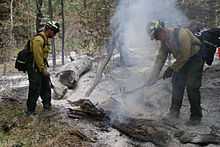
The East Peak Fire is a forest fire that began east of the East Spanish Peak near La Veta, Colorado at 5:10 PM on Wednesday, June 19, 2013.[1] The fire was originally named the Scout Ranch Fire because the fire was first reported by the Spanish Peaks Scout Ranch.
June 19, 2013 (Wednesday)
The fire was first noticed by a Boy Scout at Spanish Peaks Scout Ranch who saw smoke in the distance, and a staffer who went closer to investigate and could see visible flames.[5][6] All the Boy Scouts plus staff camping at Spanish Peaks Scout Ranch[7] quickly evacuated the camp because the staff and scouts drill for such events. Many went to the open shelter at John Mall High School in Walsenburg, Colorado, and some left to go home.[1]
June 20, 2013 (Thursday)
The fire is 1000 acres, and is zero percent contained. Strong winds are causing the fire to make runs to the east and southeast. Pre-evacuation and evacuation notifications have been sent out to locations east of La Veta to Interstate 25 and south of Walsenburg. The entire town of Walsenburg is under pre-evacuation status.[5]
June 21, 2013 (Friday)
The fire is 9100 acres, and is zero percent contained. The Spanish Peaks Scout Ranch, 9 structures, and 4 out buildings have been destroyed. About 20 homes are in the mandatory evacuation area and over 500 homes are in the pre-evacuation area. The entire town of Walsenburg is under pre-evacuation status.[1] Interstate 25, which is on the boundary of the pre-evacuation area, is still open but threatened.
June 22, 2013 (Saturday)
The fire is 11,365 acres, and is zero percent contained. The fire is about seven miles outside of Walsenburg. Smoke from the West Fork fire complex (four fires burning in southwest Colorado) is helping with the East Peak fire by "covering" the fuels.[8] The growth potential of the fire is classified as extreme.[9]
June 23, 2013 (Sunday)
The fire is 12,996 acres, and is 15% contained. On the southern perimeter, overcast conditions and favorable winds from the southeast allowed a burnout operation (a controlled burn to remove potential fuel for the fire) to be successful.[4] A large airtanker made a fire retardant drop on the western perimeter. Some of the approximately 700 residents that evacuated were being allowed back into some areas, but still on evacuation notice to leave in 10 minutes if notified. The growth potential of the fire is classified as high.[10][11]
July 9, 2013 (Tuesday)
The fire is 13,572 acres, and is 100% contained, but according to officials is not fully under control.[3]
See also
- 2013 Colorado wildfires
- Black Forest fire, another wildfire in Colorado beginning the week before
- Royal Gorge fire, another wildfire in Colorado beginning the week before
- List of Colorado wildfires
References
- ↑ 1.0 1.1 1.2 1.3 "East Peak Fire Update: June 21 #EastPeak". Colorado State DHSEM. 2013-06-21.
- ↑ 2.0 2.1 "East Peak Fire". InciWeb. Retrieved 2013-06-23.
- ↑ 3.0 3.1 3.2 "East Peak Fire fully contained, but not fully controlled". TheDenverChannel.com. 2013-07-09.
- ↑ 4.0 4.1 Katharina Buchholz (2013-06-23). "East Peak fire gets a controlled burn from firefighters in Colorado". The Denver Post.
- ↑ 5.0 5.1 Kieran Nicholson (2013-06-20). "East Peak fire at 1,000 acres; 178 Boy Scouts flee, evacuations spread". The Denver Post.
- ↑ "Scout Ranch Fire". Fox 21 News. June 19, 2013.
- ↑ "Spanish Peaks Scout Ranch". Santa Fe Trail Council, Boy Scouts of America.
- ↑ "East Peak Fire Grows To 11,365 Acres". KKTV 11 News. Jun 22, 2013.
- ↑ "East Peak Fire". InciWeb. 2013-06-22.
- ↑ "East Peak Fire". InciWeb. 2013-06-23.
- ↑ "Daily Wildfire Update". Colorado State DHSEM. 2013-06-23.