E. W. Brown Generating Station
| E. W. Brown Generating Station | |
|---|---|
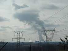 E W Brown Generating Station viewed from KY 29 | |
 Location of E. W. Brown Generating Station in USA Kentucky | |
| Country | United States |
| Location | Mercer County, near Harrodsburg, Kentucky |
| Coordinates | 37°47′N 84°43′W / 37.78°N 84.71°WCoordinates: 37°47′N 84°43′W / 37.78°N 84.71°W |
| Commission date | 1969 |
| Owner(s) | Kentucky Utilities |
| Thermal power station | |
| Primary fuel | Bituminous coal |
| Cooling source | Dix River |
| Power generation | |
| Nameplate capacity | 739 MW |
The E. W. Brown Generating Station is a coal-fired power plant owned and operated by Kentucky Utilities near Harrodsburg, Kentucky. It lies even closer to the small city of Burgin.
Emissions Data
- 2006 CO2 Emissions: 3,978,892 tons
- 2006 SO2 Emissions: 45,191 tons
- 2006 SO2 Emissions per MWh:
- 2006 NOx Emissions: 6,683 tons
- 2005 Mercury Emissions: 161 lb.