Dyfed
| Dyfed | |
|---|---|
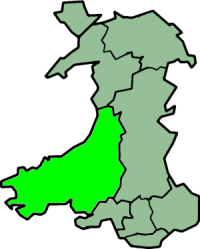 Dyfed shown as a preserved county since 2003 | |
| Area | |
| - 1974 | 5765.75 km² |
| - 1996 |
5765.75 km² Ranked 1st |
| Population | |
| - 1971 | 316,369 |
| - 1992 | 351,100 (estimate) |
| - 2007 |
375,200 (estimate)[1] Ranked 5th |
| History | |
| - Origin | Kingdom of Dyfed |
| - Created | 1974 |
| - Abolished | 1996 |
| - Succeeded by |
Carmarthenshire, Cardiganshire, Pembrokeshire Preserved county of Dyfed |
| Status | Non-metropolitan county (1974–1996) Preserved county (1996–) |
| Government |
Dyfed County Council |
| - HQ | Carmarthen |
 --> --> | |
Dyfed (Welsh pronunciation: [ˈdəvɛd]) is a preserved county of Wales. It was originally created as an administrative county council on 1 April 1974 under the terms of the Local Government Act 1972, and covered approximately the same geographic extent as the ancient Principality of Deheubarth, although excluding the Gower Peninsula and the area west of the River Tawe. The choice of the name Dyfed was based on the historic name given to the region once settled by the Irish Déisi and today known as Pembrokeshire (the historic Dyfed never included Ceredigion and only briefly included Carmarthenshire). It was formed from the administrative counties (which corresponded to the ancient counties) of Cardiganshire, Carmarthenshire, Pembrokeshire and was divided into the following local government districts:
| Administrative county 1889–1974 |
Local government districts 1974–1996 |
|---|---|
| Cardiganshire | Ceredigion |
| Carmarthenshire | Carmarthen, Dinefwr, Llanelli |
| Pembrokeshire | Preseli, South Pembroke |
The Lord Lieutenant of Pembrokeshire became Lord Lieutenant of Dyfed and the Lord Lieutenants of Cardiganshire and Carmarthenshire each became Lieutenants. The Dyfed-Powys police force had been created a number of years earlier.
Dyfed County Council
The county town and administrative headquarters of Dyfed was Carmarthen whilst the largest settlement was Llanelli. Other significant centres of population included Haverfordwest, Milford Haven and Aberystwyth.
The first election to Dyfed County Council was held in April 1973.[2] and the vast majority of the councillors elected had been members of one of the three previous county authorities which were merged to create Dyfed, namely Cardiganshire, Carmarthenshire, and Pembrokeshire. The Independents gained a majority and retained this at subsequent elections. At the 1977 election, Plaid Cymru gained some ground although not to the extent that was seen in parts of the South Wales valleys in that year.
On 1 April 1996, under the Local Government (Wales) Act 1994, Dyfed County Council was broken up and the resultant councils were based on the ancient counties, now restored for administrative purposes: Cardiganshire, the council of which renamed itself Ceredigion, the old Welsh name for the district the following day; Carmarthenshire; and Pembrokeshire. The name Dyfed was retained for such purely ceremonial purposes as the Lord Lieutenancy.
See also
- 1973 Dyfed County Council election
- 1977 Dyfed County Council election
- 1981 Dyfed County Council election
- Chairs of Dyfed County Council
- List of Lord Lieutenants of Dyfed
- List of High Sheriffs of Dyfed
References
- ↑ Office for National Statistics – 2007 estimate (using 2003 preserved borders for Camarthenshire, Ceredigion, Pembrokeshire
- ↑ Western Mail. 13 April 1973. Missing or empty
|title=(help);