Dutch Caribbean
|
Flag of the Kingdom of the Netherlands | |
|
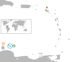
Location of the Dutch Caribbean islands
| |
| Area | 999 km2 (386 sq mi) |
|---|---|
| Population (2010) | 315,339 |
| GDP (Nominal) | US$ 8.911 billion[1] |
| GDP per Capita (Nominal) | US$ 29,240[1] |
| Density | 305/km2 (790/sq mi) |
| Languages | Dutch, English, Papiamento |
| Government |
3 constituent countries 3 special municipalities |

The term Dutch Caribbean refers to all of the islands of the Kingdom of the Netherlands that are located in the Caribbean, regardless of their legal status in Dutch law, and to the inhabitants of those islands.[2][3] All the islands in the Dutch Caribbean were, at some point in history, part of the Netherlands Antilles and its predecessor the colony of Curaçao and its dependencies. The former Dutch colony of Surinam, although it was relatively close by, was not considered to be part of Dutch Caribbean as it was on the continent of South America.
History
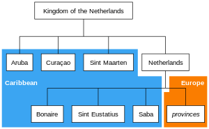
The island of Aruba gained autonomy in 1986. Following the dissolution of the Netherlands Antilles in 2010, the islands of Curaçao and Sint Maarten also became automomous within the Kingdom of the Netherlands. The remaining islands became integrated into the Netherlands proper. Currently, there are two main divisions in the Dutch Caribbean:
- those islands that have the status of being constituent countries of the Kingdom of the Netherlands
- those islands that have the status of being special municipalities of the Netherlands alone, as distinct from the Kingdom in its entirety.
Constituent countries
There are three Caribbean islands that are countries (Dutch: landen) within the Kingdom of the Netherlands: Aruba, Curaçao, and Sint Maarten. The latter country is approximately one half of the island of Saint Martin; the remaining northern half of the island - the Collectivity of Saint Martin - is an overseas territory of France.
Special municipalities
There are three Caribbean islands that are special municipalities of the Netherlands alone: Bonaire, Sint Eustatius, and Saba. The Netherlands is the fourth constituent country in the Kingdom of the Netherlands. Collectively, these special municipalities of the Netherlands are also known as the "BES islands". There are also several smaller islands, like Klein Curaçao and Klein Bonaire, that belong to one of the island countries or special municipalities.
Grouping of islands
There are several acronyms that indicate informal groups of islands of the Dutch Caribbean:
- ABC islands, for Aruba, Bonaire, and Curaçao;
- BES islands, for Bonaire, Sint Eustatius, and Saba;
- SSS islands, for Saba, Saint Martin, and Sint Eustatius.
-
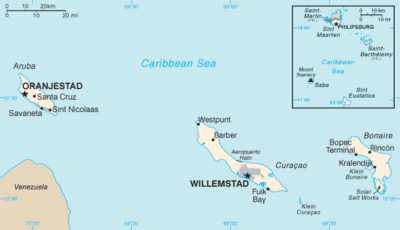
Map of the Dutch Caribbean islands.
-
Those countries and special municipalities of the Kingdom of the Netherlands that are located in the Caribbean (blue background)
See also
References
- ↑ 1.0 1.1 COUNTRY COMPARISON GDP, Central Intelligence Agency.
- ↑ "Visa for the Dutch Caribbean". Netherlands Embassy in the United Kingdom. Retrieved 7 May 2013.
- ↑ "Rijksdienst Carbische Nederland (Rijksdienst Dutch Caribbean)". Government of the Netherlands. Retrieved 26 July 2012.
| Wikimedia Commons has media related to Dutch Caribbean. |
| |||||||||||||