Durtal
For the racehorse, see Durtal (horse).
| Durtal | |
|---|---|
 | |
 Durtal | |
|
Location within Pays de la Loire region  Durtal | |
| Coordinates: 47°40′22″N 0°14′24″W / 47.6728°N 0.24°WCoordinates: 47°40′22″N 0°14′24″W / 47.6728°N 0.24°W | |
| Country | France |
| Region | Pays de la Loire |
| Department | Maine-et-Loire |
| Arrondissement | Angers |
| Canton | Durtal (chef-lieu) |
| Intercommunality |
C. C. des Portes-de-l'Anjou Pays des Vallées d'Anjou |
| Government | |
| • Mayor (2008–2014) | André Logeais |
| Area1 | 60.58 km2 (23.39 sq mi) |
| Population (2006)2 | 3,310 |
| • Density | 55/km2 (140/sq mi) |
| INSEE/Postal code | 49127 / 49430 |
| Elevation |
21–94 m (69–308 ft) (avg. 34 m or 112 ft) |
|
1 French Land Register data, which excludes lakes, ponds, glaciers > 1 km² (0.386 sq mi or 247 acres) and river estuaries. 2 Population without double counting: residents of multiple communes (e.g., students and military personnel) only counted once. | |
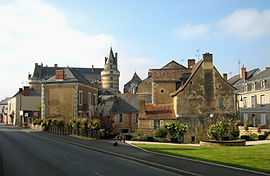
Durtal is a commune in the Maine-et-Loire department in western France. It is around 32 km north-east of Angers the department capital.
See also
References
| Wikimedia Commons has media related to Durtal. |