Durham County, New South Wales

Durham
New South Wales

Location in New South Wales
Lands administrative divisions around Durham:
Brisbane Hawes Gloucester
Brisbane Durham Gloucester
Hunter Northumberland Gloucester

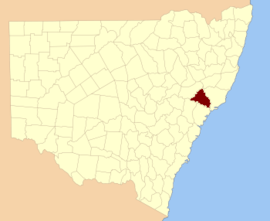
Durham County was one of the original Nineteen Counties in New South Wales and is now one of the 141 Cadastral divisions of New South Wales. It is bordered on the south and west by the Hunter River, and on the north and east by the Williams River. It includes Aberdeen and Muswellbrook. Before 1834, the area known as Durham County included what later became Gloucester and most of Brisbane counties, as far west as the Liverpool Range, and east to the Pacific, including Port Stephens, as shown on an 1832 map.

Durham County was named in honour of John George Lambton, First Earl of Durham (1792-1840).[1]

Parishes within this county

A full list of parishes found within this county; their current LGA and mapping coordinates to the approximate centre of each location is as follows:

Parish LGA Coordinates
Allyn Dungog Shire 32°07′54″S 151°28′04″E / 32.13167°S 151.46778°E
Althorpe Muswellbrook Shire 32°24′54″S 150°46′04″E / 32.41500°S 150.76778°E
Auckland Singleton Council 32°30′54″S 151°06′04″E / 32.51500°S 151.10111°E
Avenal Dungog Shire 32°18′54″S 151°34′04″E / 32.31500°S 151.56778°E
Balmoral Muswellbrook Shire 32°14′54″S 150°59′04″E / 32.24833°S 150.98444°E
Barford Dungog Shire 32°32′54″S 151°38′04″E / 32.54833°S 151.63444°E
Belltrees Upper Hunter Shire 31°58′54″S 151°10′04″E / 31.98167°S 151.16778°E
Boonabilla Dungog Shire 32°07′54″S 151°22′04″E / 32.13167°S 151.36778°E
Bronte Upper Hunter Shire 31°53′54″S 151°24′04″E / 31.89833°S 151.40111°E
Brougham Muswellbrook Shire 32°18′54″S 150°53′04″E / 32.31500°S 150.88444°E
Butterwick Port Stephens Council 32°39′54″S 151°38′04″E / 32.66500°S 151.63444°E
Carrow Dungog Shire 32°14′54″S 151°21′04″E / 32.24833°S 151.35111°E
Chalmers Upper Hunter Shire 32°02′54″S 151°13′04″E / 32.04833°S 151.21778°E
Colonna Dungog Shire 32°14′54″S 151°31′04″E / 32.24833°S 151.51778°E
Darlington Singleton Council 32°30′54″S 151°11′04″E / 32.51500°S 151.18444°E
Doon Upper Hunter Shire 32°05′54″S 151°15′04″E / 32.09833°S 151.25111°E
Dungog Dungog Shire 32°25′54″S 151°43′04″E / 32.43167°S 151.71778°E
Dyrring Singleton Council 32°25′54″S 151°17′04″E / 32.43167°S 151.28444°E
Fingal Dungog Shire 32°27′54″S 151°36′04″E / 32.46500°S 151.60111°E
Foy Muswellbrook Shire 32°13′54″S 151°09′04″E / 32.23167°S 151.15111°E
Glendon Dungog Shire 32°21′54″S 151°22′04″E / 32.36500°S 151.36778°E
Goorangoola Singleton Council 32°23′54″S 151°08′04″E / 32.39833°S 151.13444°E
Gotha Singleton Council 32°18′54″S 151°17′04″E / 32.31500°S 151.28444°E
Gresford Dungog Shire 32°29′54″S 151°32′04″E / 32.49833°S 151.53444°E
Herschell Muswellbrook Shire 32°13′54″S 151°05′04″E / 32.23167°S 151.08444°E
Holywell Dungog Shire 32°19′54″S 151°30′04″E / 32.33167°S 151.50111°E
Houghton Dungog Shire 32°36′0″S 151°33′57″E / 32.60000°S 151.56583°E
Howick Singleton Council 32°27′54″S 150°56′04″E / 32.46500°S 150.93444°E
Lewinsbrook Dungog Shire 32°22′54″S 151°33′04″E / 32.38167°S 151.55111°E
Liddell Muswellbrook Shire 32°21′54″S 151°00′04″E / 32.36500°S 151.00111°E
Liebeg Singleton Council 32°14′54″S 151°15′04″E / 32.24833°S 151.25111°E
Mamaran Upper Hunter Shire 31°47′54″S 151°24′04″E / 31.79833°S 151.40111°E
Marwood Singleton Council 32°33′54″S 151°21′04″E / 32.56500°S 151.35111°E
Middlehope Dungog Shire 32°39′54″S 151°38′04″E / 32.66500°S 151.63444°E
Mirannie Singleton Council 32°27′54″S 151°20′04″E / 32.46500°S 151.33444°E
Moonan Upper Hunter Shire 31°56′54″S 151°14′04″E / 31.94833°S 151.23444°E
Mount Royal Singleton Council 32°10′54″S 151°18′04″E / 32.18167°S 151.30111°E
Oldcastle Upper Hunter Shire 32°00′54″S 151°19′04″E / 32.01500°S 151.31778°E
Omadale Upper Hunter Shire 31°51′54″S 151°20′04″E / 31.86500°S 151.33444°E
Prospero Upper Hunter Shire 31°59′54″S 151°22′04″E / 31.99833°S 151.36778°E
Ravensworth Singleton Council 32°29′54″S 151°00′04″E / 32.49833°S 151.00111°E
Rosamond Singleton Council 32°09′54″S 151°15′04″E / 32.16500°S 151.25111°E
Rouchel Upper Hunter Shire 32°07′54″S 151°00′04″E / 32.13167°S 151.00111°E
Rowan Muswellbrook Shire 32°13′54″S 150°57′04″E / 32.23167°S 150.95111°E
Russell Upper Hunter Shire 32°09′54″S 150°57′04″E / 32.16500°S 150.95111°E
Savoy Muswellbrook Shire 32°20′54″S 150°57′04″E / 32.34833°S 150.95111°E
Seaham Port Stephens Council 32°39′25″S 151°41′57″E / 32.65694°S 151.69917°E
Sedgefield Singleton Council 32°31′54″S 151°15′04″E / 32.53167°S 151.25111°E
Shenstone Singleton Council 32°23′54″S 151°12′04″E / 32.39833°S 151.20111°E
St Aubins Upper Hunter Shire 32°10′54″S 151°00′04″E / 32.18167°S 151.00111°E
St Julian Dungog Shire 32°22′54″S 151°28′04″E / 32.38167°S 151.46778°E
Stanhope Singleton Council 32°33′54″S 151°25′04″E / 32.56500°S 151.41778°E
Tangory Singleton Council 32°28′54″S 151°24′04″E / 32.48167°S 151.40111°E
Tillegra Dungog Shire 32°20′54″S 151°42′04″E / 32.34833°S 151.70111°E
Tudor Upper Hunter Shire 32°10′54″S 151°08′04″E / 32.18167°S 151.13444°E
Tyraman Dungog Shire 32°29′54″S 151°30′04″E / 32.49833°S 151.50111°E
Uffington Dungog Shire, Port Stephens Council 32°35′54″S 151°44′04″E / 32.59833°S 151.73444°E
Underbank Dungog Shire 32°14′54″S 151°33′04″E / 32.24833°S 151.55111°E
Vane Singleton Council 32°26′54″S 151°07′04″E / 32.44833°S 151.11778°E
Vaux Muswellbrook Shire 32°20′54″S 150°47′04″E / 32.34833°S 150.78444°E
Wallarobba Dungog Shire 32°28′54″S 151°43′04″E / 32.48167°S 151.71778°E
Wolfingham Dungog Shire 32°37′54″S 151°29′04″E / 32.63167°S 151.48444°E
Wynn Muswellbrook Shire 32°21′54″S 150°52′04″E / 32.36500°S 150.86778°E

References

  1. "Durham". Geographical Names Register (GNR) of NSW. Geographical Names Board of New South Wales. Retrieved 5 August 2013.

External links