Durdle Pier
Durdle Pier is a disused 17th-century stone shipping quay, located on the Isle of Portland, Dorset, England; part of the Jurassic Coast. It is found close by Yeolands Quarry, on the east side of the island within the area of East Weares and Penn's Weare.[1]
History


Durdle Pier dates back to the 17th century when the surrounding area was quarried.[2] When British architect Inigo Jones chose Portland Stone for the rebuilding of the Banqueting House at Whitehall, London, in 1619, the island's stone became increasingly popular. The three-year contract between Jones and the island gave Portland the chance to build various roads, and also piers along East Weares coastline. Durdle Pier was one of these, and became one of the main stone shipping places on the east side.[3] With the establishment of the stone industry, quarry owners were given the right to erect piers with cranes for shipping stone from anywhere along the coastline.
The limestone quarries of East and Penn's Weares were the earliest to be quarried on the island, and were the location of Sir Christopher Wren's first workings of stone to rebuild London after the Great Fire of 1666. The quarries occupied a 200-300m wide strip along the east coast of the island between Church Ope Cove and King's Pier. At Penn's Weare the dressing process remains clear and evident from roughly dressed stone to finely square blocks, with dressing rough-out piles in situ. These remains continue northwards into East Weare, although 19th and 20th century development has caused significant damage.[4]
By the beginning of the 18th century Durdle Pier, King's Pier, as well as three piers situated around Church Ope Cove, had become well-established and favoured amongst Portland's piers. Other piers were located around the island's rugged coast; near Freshwater Bay, Underbank near Southwell, Folly Pier, as well as piers at West Weares, under West Cliff. However the latter proved to be briefly in use due to the unstable nature of the coastline, as well as a lack of roads. The best location for shipping stone was Castletown Pier, however it was situated far from the majority of the working quarries. The tracks from the quarries to the piers on the coastline were inadequate, and often impaired by heavy carts as well as landslides. If such a way was unable to be used, the neighbouring landowner was expected to allow quarry traffic to divert through their land, in return for Road Dues.[5] In the area the stone was shipped from the adjacent Durdle, Folly, and King's Piers, although only Durdle Pier remains well-preserved.[4]
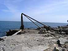
The pier was one that architect Wren used to load Portland stone on to barges and sail to London for the rebuilding of the city. It is rumoured that there are a couple of blocks of Portland stone lying around the area with Wren's 'wine glass' symbol engraving.[6] Some roughly shaped stone still lies in the area, once ready for shipping but now abandoned.[7] Around 1840-70, the original crane was replaced with a crane made by Galpin of Dorchester. The last crane to be on the pier was at least the third to ever be placed at the site. A small re-entrant is faced with two stone walls each about 50 ft long and forming a right angle.[3] During the storms of early 2014, the pier's crane was destroyed by the sea. Three separate parts of the destroyed crane lie further north of the pier along the coastline - two of which are located within the area of the Salt Pans.
As quarries moved inland from the cliffs, fishermen became the pier's main users. The crane was one of the few remaining cranes used for lifting boats from the water around Portland's coast, and the crane along with the isolated pier was still used into the 21st century until the crane became broken and beyond repair.[8] The winding gear had become badly rusted and pieces of it remain scattered around the site, although the main timbers remained in good condition.[9] Close to the old hand winch Derrick Crane was also a number of fishermen's huts at the water's edge, although none of these exist today. The pier is now a popular place for recreational fishing.[10]
Within close proximity to Durdle Pier are two World War II pillboxes. One is located on the seaward side of the Weares, south of the pier, whilst the other is found further up, halfway between seaward edge of East Weares/Penn's Weare and the disused railway track. Both structures are the only two camouflaged pillboxes on Portland, designed to blend in with the boulder strewn area of the Weares. The pillboxes were constructed in 1940-41 and is built of concrete and Portland stone. As with many of Portland's pillboxes and heavy anti-aircraft batteries, these structures would probably have been built by local quarrymen. A field visit in 1995 found both structures to be in a good condition, and this remains the same in 2014, although both have been a victim of some graffiti. Both remain accessible.[11][12]
The Grove Cliffs surrounding the pier are a sanctuary area for breeding birds, such as fulmars.[7] The Great Southwell Landslip, Britain's second largest recorded historical landslide, occurred in 1734, between Durdle Pier and Freshwater Bay, at a distance of one and a half miles.[13] The Dorset names Durlston Bay and Head (in Swanage) and Durdle Pier, again without early spellings, can be associated etymologically with Durdle Door.[14]
References
- ↑ "Yeolands Quarry and Durdle Pier, Portland, Dorset". Geoffkirby.co.uk. Retrieved 2013-03-02.
- ↑ http://www.visitweymouth.co.uk/downloadForms/RailwayWalkleaflet.pdf
- ↑ 3.0 3.1 "Detailed Result: DURDLE PIER". Pastscape. Retrieved 2013-03-02.
- ↑ 4.0 4.1 http://www.pastscape.org.uk/hob.aspx?hob_id=1466569
- ↑ Morris, Stuart (1985). Portland: An Illustrated History. Dovecote Press. p. 54. ISBN 978-0946159345.
- ↑ Filaos Prods (2007-04-28). "high and dry". Senegalaisement.com. Retrieved 2013-03-02.
- ↑ 7.0 7.1 http://www.visit-dorset.com/dbimgs/Church%20Ope%20-%20Circular%20Walk.pdf
- ↑ petervanallen Peter Allen+ Add Contact. "Durdle Pier | Flickr - Photo Sharing!". Flickr. Retrieved 2013-03-02.
- ↑ Anthony Houghton. "Church Ope Cove and Penn's Weare - Information & Photographs". Strolling Guides. Retrieved 2013-03-02.
- ↑ Rhys (2009-08-03). "Chesil beach and Portland fishing: Durdle Pier ( Portland )". Fisheywishey.blogspot.co.uk. Retrieved 2013-03-02.
- ↑ http://www.pastscape.org.uk/hob.aspx?hob_id=1420399&sort=2&type=&rational=a&class1=None&period=None&county=93347&district=93625&parish=93626&place=pillbox&recordsperpage=10&source=text&rtype=&rnumber=&p=1&move=n&nor=28&recfc=0
- ↑ http://www.pastscape.org.uk/hob.aspx?hob_id=1420401&sort=2&type=&rational=a&class1=None&period=None&county=93347&district=93625&parish=93626&place=pillbox&recordsperpage=10&source=text&rtype=&rnumber=&p=1&move=n&nor=28&recfc=0
- ↑ http://www.jurassiccoastline.com/jurassic_Info1b.asp?ID=153&AreaID=153
- ↑ "Durdle Door, Dorset, England". Thedorsetpage.com. Retrieved 2013-03-02.
Coordinates: 50°32′39″N 2°25′04″W / 50.5441°N 2.4179°W
| ||||||||||||||||||||||||||||||||||||||||||||||||||||||||||||||||||